|
Судно
не приспособлено для лоцманского трапа.
1. Permission
to take pilot, at... UTC , have , in position... you. -
INFORMATION. -
2. embark,
at...hours local time , will, pilot -
3. vessel, your,
pilot boat, approaching , is -
. pilot, on , port
side , keep boat -
. pilot transfer,
change to , for, VHF channel -
. wait for, in,
pilot, in present, stop , position and -
. pilot transfer,
for, VHF channel, change to -
. completed , stand
by , until, pilot transfer , on VHF channel -
. suspended ,
pilotage at, (name) Pilot Station ,until... (date and local time) -
. due to , Pilot
Station , cannot, pilot, embark at -
(Abridged from the
IMO Standard Marine Communication Phrases) Exercise 14. Standard Marine
Communication Phrasesthe word order in the following sentences right or wrong?
Correct the sentences thai are wrong. Follow the examples given in the first
and the second sentences Examples:
1...... INFORMATION.
Pilot ladder has broken steps.
Right
2. INFORMATION.
You may navigate by yourself (or wait for pile
at... station),
... Wrong
INFORMATION. You may navigate by yourself (or wait for pile at... buoy).
3. INFORMATION.
Pilotage at (name) Pilot Station resumed.
4. INFORMATION.
Pilot boat approaching.
. INFORMATION.
Pilot will embark at...hours local time.
. INFORMATION. You
are exempted from pilotage.
. INFORMATION.
Pilotage at (name) Pilot Station suspended until...(date and time).
. INFORMATION.
Pilot cannot embark at (name) Pilot Station because...
. INFORMATION.
Pilot ladder unsafe.
. INFORMATION.
Embarkation possible.
11.INFORMATION.
Vessel suited for pilot ladder.
12.INFORMATION.
My ETA at... (name) Pilot Station... hours local time.
13. INFORMATION.
Boarding arrangements do not comply with SOLAS -Regulations.
(Abridgedfrom the
IMO Standard Marine Communication Phrases).15. Re-order the following groups of
words to make questions.the example given in the first sentence:
1.pilot,
take , I, must Must I take pilot?
2.require,
you , do , pilot
3. at..., (name)
Pilot Station ,you, do ,pilot, require
. is ,ETA, at...
(name)Pilot Station ,what ,your, in , local time
. local, is , time,
what
. Present, what,
your position
. distance , (name)
Pilot Station , what, your, is from
. station, pilot
boat, on , is
. position , I,
Pilot, can, what, take, in
. will, embark ,
pilot ,when
. freeboard, is,
your, what
. accept, shore
based navigational, do, assistance , you, from, pilot
. wrong , what,
with , is , pilot ladder16. Make the following sentences into questions
acceptable in standard communications (IMO SMCP). Follow the example given in
the first sentence Example:
1.
Do you know when the pilot will
embark? ...QUESTION. When will pilot embark?...
2.
Could you please tell us if you
require pilot?
3. Could you tell
me your ETA at... (name) Pilot Station?
. Would it be
possible for you to inform us whether you can proceed without pilot?
. Could you tell me
what your freeboard is?
. Do you know if a
pilot boat is on the station?
. Could you tell us
what your present position is?
. Do you know the
local time?17. Fill in the missing words in the text belowfrom the following
list using appropriate form of the verb
must manoeuvre call
for may hoist mean require
come embark meet show
to
In some ports,
ships. take pilots. They...... take pilots...... the ship
into or out of the
harbour. Ships may.................................. a pilot by radio or by
hoisting the signal. They.................... also call for a pilot by
radiotelephone. Ships usually the International Code Flag "G". This
flag "I require a pilot". Soon the pilot boat
alongside the ship
and the pilot her. The watch officer.... the pilot at
the ladder. Then he......... him the
bridge.
. Match the
opposites
|
1. to arrive
|
a) to disembark
|
|
2. to berth
|
b) to complete
|
|
3. to proceed
|
c) to depart
|
|
4. to start
|
d) to unberth
|
|
5. to embark
|
e) to stay
|
|
6. to resume
|
f) to break
|
|
7. to repair
|
g) to suspend
|
|
8. to keep
|
h) to hoist
|
|
9. to low
|
i) to increase
|
|
10. to decrease
|
j) to move
|
. Choose the right
answer
1. Where may
pilots be obtained?
a)
from the office of the Harbour
Master
b)
from the port pilot station
c)
in the offing
2. What flag
should a vessel display when she requires pilot in daylight?
a)
the flag "H"
b)
the flag "G"
c)
the flag "K"
3. What does
the flag "G" mean?
a)
I have a pilot aboard
b)
I require a pilot
c)
I want to communicate with you
4. What is
the signal for a pilot at night?
a)
the flag "G"
b)
blasts on the ship's siren
c)
blasts on the ship's whistle
5. What must
captains indicate when requesting pilots by?
a)
the ETA of the ship
b)
the name of the ship
c)
the draught of the ship
Exercise 20. Match
the synonymes
1.
to inform a) to understand
2.
to depart b) to unload
3.
to arrive c) to contact
4.
to acknowledge d) to berth
5.
to comprehend e) to leave
6.
to communicate f) to come
7.
to moor g) to confirm
8.
to discharge h) to advise
9.
to carry out i) to get
10. to
receive j) to fulfill
Exercise 21. Which
letter flags deal with the topic "PILOTAGE AND PILOTS"? Name
them5activitywatching the video programme "Bridge Routines " study
the dialogue and be ready to watch the film:ship is at sea, running up to the
Pilot Station. The entire action, with the exception of the Third Officer's reply,
takes place inside the wheelhouse.are the Master, the watchkeeping Officer
(2/0), a helmsman and the Pilot.
|
Pilot (to 2/0):
|
Half ahead.
|
|
|
2/0 (Rings Telegraph):
|
Half ahead, Pilot.
|
|
|
Pilot:
|
Starboard Ten.
|
|
|
Helmsman:
|
Starboard Ten, Sir.
|
|
|
Pilot:
|
Midships.
|
|
|
Helmsman:
|
Midships, Pilot.
|
|
|
Pilot:
|
Steer zero zero three.
|
|
|
Helmsman:
|
Midships. Steady on zero zero
three, Pilot.
|
|
|
Pilot:
|
Dead slow ahead.
|
|
|
2/0 (Rings Telegraph):
|
Dead slow ahead, Pilot.
|
|
|
Pilot (to helmsman):
|
What is your course?
|
|
|
Helmsman:
|
My course is zero zero three, Sir.
|
|
|
Pilot (to Master):
|
Captain, we are coming up to the
pilot station. Please rig pilot ladder on starboard side, one metre above the
|
|
|
water.
|
|
Master (to Pilot):
|
Yes, Pilot.
|
|
Master (on radio):
|
"Arabiyah" Captain to
Third Mate. Rig the pilot ladder on starboard side, one metre above the
water. Have a lifebuoy and heaving line ready, then report to the bridge.
|
|
3/0 (on deck, on radio):
|
"Arabiyah" Third Mate to
Captain. Rig pilot ladder on starboard side one metre above the water. Have a
lifebuoy and heaving line ready. Г1 come up
to the bridge when all is ready, Sir.
|
|
Pilot (to Master):
|
Captain, when I've left, keep
steering zero zero three. This will take you to the fairway buoy. Pass the
buoy, then you can set course to the east.
|
|
Master (to Pilot):
|
Alter course at the fairway buoy.
Thank you, Pilot.
|
|
3/0 (to Pilot):
|
The Pilot boat is approaching,
Sir.
|
|
Pilot:
|
Please, sign my papers, Captain.
|
|
Master:
|
Certainly, Pilot.
|
|
Pilot:
|
Thank you. Good-bye, Captain.
|
|
Master:
|
Thank you, Pilot. Third Mate,
please take the Pilot down.
|
|
3/0:
|
Yes, Sir.
|
|
Master (to 2/0):
|
Stop Engines.
|
|
2/0 (to Master):
|
Engines stopped, Sir.
|
|
Master (to helmsman):
|
Steady. Let me know when she does
not answer the wheel.
|
|
Helmsman (to Master):
|
Steady on zero zero three, Sir.
|
|
|
|
|
UNIT 5. LIGHTS
PART
I. Vocabulary and reading
these words orally
and learn them by heart
 Light - огонь
fa Alternating I. - переменный
огонь
fa Anchor I. ~ якорный
огонь
fa Fixed I - постоянный огонь
fa Flashing I - проблесковый
огонь
fa Front I. - передний огонь
fa Group-flashing I. - группо-проблесковый
огонь
fa Group-occulting I - группо-затмевающийся
огонь
fa Leading I. - створный
огонь
fa Masthead I. - топовый
огонь
fa Navigation I. - ходовой
огонь
fa Occulting I. - затмевающийся
огонь
fa Rear I. - задний огонь
fa Revolving I - вращающийся
огонь
fa Riding I. - штаговый
огонь
fa Stern I - гакабортный огонь
fa Unwatched I. - необслуживаемый
огонь
fa Isophase light I. - изофазный
огонь
fa Eclipse - затмение
fa Elevation - высота
(над
уровнем
моря)
fa Exhibit показывать,
выставлять,
зажигать
(огонь)
fa Flash - вспышка, проблеск;
подавать
световой
сигнал
fa Height - высота (объекта)
fa Lantern - фонарь fa To
obscure - затемнять
fa Show - показывать,
выставлять
(огонь)
fa Visibility - видимость
fa Visible ~ видимый fa
Structure - постройка,
сооружение
fa Pile - столб, свая
fa Pillar- стойка, столб
fa Pole ~ столб, шест
fa Post - столб, веха
fa Staff- шест, шток
fa Tower ~ башня fa Mast- мачта1.
Scan the text and complete the chartare used to ensure safe navigation. There
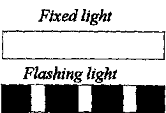
are several types of lights. The main of them are the following:Fixed light is
a light that shines continuously. Its abbreviation is F. All lights are
indicated by abbreviations on nautical charts.Flashing light is a light with a
short light interval anda long dark interval. Its abbreviations is FI, but in
nautical charts the abbreviations of the corresponding rhythms Light - огонь
fa Alternating I. - переменный
огонь
fa Anchor I. ~ якорный
огонь
fa Fixed I - постоянный огонь
fa Flashing I - проблесковый
огонь
fa Front I. - передний огонь
fa Group-flashing I. - группо-проблесковый
огонь
fa Group-occulting I - группо-затмевающийся
огонь
fa Leading I. - створный
огонь
fa Masthead I. - топовый
огонь
fa Navigation I. - ходовой
огонь
fa Occulting I. - затмевающийся
огонь
fa Rear I. - задний огонь
fa Revolving I - вращающийся
огонь
fa Riding I. - штаговый
огонь
fa Stern I - гакабортный огонь
fa Unwatched I. - необслуживаемый
огонь
fa Isophase light I. - изофазный
огонь
fa Eclipse - затмение
fa Elevation - высота
(над
уровнем
моря)
fa Exhibit показывать,
выставлять,
зажигать
(огонь)
fa Flash - вспышка, проблеск;
подавать
световой
сигнал
fa Height - высота (объекта)
fa Lantern - фонарь fa To
obscure - затемнять
fa Show - показывать,
выставлять
(огонь)
fa Visibility - видимость
fa Visible ~ видимый fa
Structure - постройка,
сооружение
fa Pile - столб, свая
fa Pillar- стойка, столб
fa Pole ~ столб, шест
fa Post - столб, веха
fa Staff- шест, шток
fa Tower ~ башня fa Mast- мачта1.
Scan the text and complete the chartare used to ensure safe navigation. There
are several types of lights. The main of them are the following:Fixed light is
a light that shines continuously. Its abbreviation is F. All lights are
indicated by abbreviations on nautical charts.Flashing light is a light with a
short light interval anda long dark interval. Its abbreviations is FI, but in
nautical charts the abbreviations of the corresponding rhythms
 Q
(quick - 50-80 flashes per minute) or VQ (very quick - 80-160 flashes per
minute) are used.characteristic of the Occulting light is contrary to that of
the flashing light: the occulting light has a long light interval and a short
dark interval. In other words: it Q
(quick - 50-80 flashes per minute) or VQ (very quick - 80-160 flashes per
minute) are used.characteristic of the Occulting light is contrary to that of
the flashing light: the occulting light has a long light interval and a short
dark interval. In other words: it

an interrupted
light.abbreviation is Oc/Occ.lights are flashing or occulting lights in which
the light-intervals are exhibited in groups that are repeated at regular
intervals, for example F (3) or Oc (2).Isophase light has a light interval and
a dark interval of equal durations. Its abbreviation is ISO.lights are mostly
of white (W), red (R), blue

(BVBu) and green
(Gt) colour. In case a light changes its colour it is called
alternating.Alternating light (Al) is a light that shows different colours
alternately, for example ALWGR (Alternating light White/ Green/ Red).Morse Code
light is a light in which appearances of light of two clearly different
durations are grouped to represent a character or characters in the Morse
Code.applications of the types of light are determined by the fact whether a
light is conspicuous or not.most conspicuous light by far is the Flashing
light. Therefore it is always used to indicate danger.least conspicuous light
is the Fixed light Therefore it should merely be used to illuminate an object
or an area.are exhibited from different conspicuous structures, such as towers,
poles, posts, buoys, beacons, staffs, masts and lighthouses.2. Before
completing the table watch the CD-ROM pro-gram "International Maritime
English Programme " (Lights)
|
Types of lights
|
Characteristics
|
|
|
|
|
Exercise 3. Answer
the questions
1.
What types of lights are mentioned
in the text?
2.
What light shines continuously?
3.
What is the characteristic of Fl?
4.
What do abbreviations Q and VQ mean?
5.
What is the difference between Fl
and Oc?
6.
Which light has light intervals
equal to dark intervals?
7.
What is Al?
8.
What are group lights?
9.
What light is the most conspicuous?
10. What is a
fixed light used for?
Exercise 4. Find in
the text above the English equivalents for the following words and expressions
1.
Изофазный
огонь
2.
хорошо
видимый (приметный)
3.
шест,
шток
4.
столб,
шест
5.
постоянный
огонь
6.
башня
7.
затмевающий
огонь
8.
столб,
стойка
9.
переменный
огонь
10.
морская
карта
11.
показывать
(выставлять) огонь
12.
проблесковый
огонь
13.
огонь
Морзе
14.
группо-затмевающийся
огонь
15.
очень
быстрый проблесковый огонь
Exercise 5. Choose
the correct answer
1. A light
which is constantly visible.
a)
a flashing light
b)
a fixed light
c)
an occulting light
d)
an isophase light
2. A light
which changes its colour is ...
a)
flashing
b)
green
c)
red
d)
alternating
3. A light
which has a light and a dark interval of equal durations is ...
a)
constantly invisible
b)
isophase
c)
occulting
d)
leading
4. A light
which has a longer light interval and a shorter dark one.
a)
an occulting light
b)
an isophase light
c)
a fixed light
d)
a flashing light
5. The
duration of eclipse is longer than that of light.
a)
a flashing light
b)
a fixed light
c)
an occulting light
d)
an isophase light
6. The most
conspicuous light by far is ...
a)
a fixed light
b)
a flashing light
c)
an isophase light
d)
an occulting light
Exercise 6. Read
andtranslate passages from Pilot Books. Check yourself by finding the
corresponding Russian translation
|
1. K. light is exhibited, at an
elevation of 28 feet (8m5), from a black metal structure with a red lantern,
24 feet (7m3) in height, situated on the west ern side of the entrance to the
harbour (Lat.51o26'N,Long.4o00'E) 2. A white group-flashing light showing two
flashes every ten seconds is shown westward from L. point. • 3. A light is
exhibited on each side of the entrance to D.
|
a)
Два огня, расположенные по вер тикали на высоте 20 и 26 футов (6,1 и 7,9м),
установлены на белой бетонной мачте с черными поло сами 16 футов (4,9 м)
высотой, расположенной на оконечности мола Б. b) Огонь К. установлен на
высоте 28 футов (8,5 м) на чёрной металли ческой конструкции с красным
фонарём высотой 4 фута (7,3 м), расположенной на западной сто роне входа в
гавань (51°26'N. 4°00'Е). c) Белый
группопроблесковый огонь, показывающий два проблеска ка ждые десять секунд,
зажигается западнее мыса Л.
|
4.
В.
and N. lights in line, bearing 149°, 1 lead to the harbour. 5. Two lights,
disposed vertically at ele vations of 20 and 26 feet (6ml and 7m9), are
exhibited from a white con crete mast with black bands, 16 feet (4m9) in
height, situated on the head ofthemole.fi <#"528383.files/image037.gif"> Light structure - маячная
постройка
Р^
Truncated structure - пирамидальная
постройка
Р*
Brick - кирпич;
кирпичный
Р"
Concrete - бетон; бетонный
Р^
Iron - железо;
железный
^ Steel - сталь; стальной
Р5"
Stone - камень;
каменный
Р^
Wood-дерево
Р5'
Wooden деревянный
Р"
Angle - угол
Р^
Circular - круглый Р"
Hexagonal - шестиугольный Р5"
Octagonal - восьмиугольный Р"
Pyramidal пирамидальный Р^
Quadrangular - четырёхугольный
^Rectangular прямоугольный Р="
Square квадратный
Р^
Triangular - треугольный18.
Read the text and answer the questionslighthouse is a structure exhibiting a
light. This light serves as an aid to navigation. Lighthouses are always
conspicuous.are built on land and at sea. In most cases lighthouses are erected
on solid foundations.vary in shape. They can be circular, pyramidal,
quadrangular, square, cylindrical triangular, rectangular, hexagonal and
octagonal. They are built of stone, brick, concrete, iron, steel, wood, etc.are
painted white, yellow, red, etc. Sometimes they are painted in horizontal and
vertical stripes of different colours. (A band is a horizontal line, a stripe
is a vertical line). The lights may be fixed, flashing, occulting, alternating,
group-flashing.leading lights are exhibited, the front light is always lower
than the rear light.may be connected to the telephone system for life-saving
purposes.
1.
What purpose does a lighthouse
serve?
2.
Where are lighthouses built?
3.
What shape can lighthouses be?
4.
What material are lighthouses built
of?
5.
What types of lights may be
exhibited from lighthouses?
6.
What does the Odessa lighthouse look
like?
7.
Which light is exhibited higher, the
front or the rear one?
Exercise 19.
Translate from Russian into English
1.
Маяк
- постройка, на которой выставлен огонь.
2.
Маяки
устанавливаются на берегу и в море.
3.
Маяки
могут иметь ажурное основание.
4.
Имеются
различные формы маячных построек.
5.
Для
постройки маяков используются различные материалы: камень, фпич, железо, сталь.
6.
Огни
бывают разного цвета: зелёные, белые, красные, жёлтые.
7.
На
маяках выставляются постоянные, переменные, проблесковые, задевающиеся и другие
огни.
8.
На
плавучий маяк нельзя полагаться.
9.
Находится
ли маяк на своём штатном месте?
10.
На
каком расстоянии от порта находится этот маяк?
11.
Плавучий
маяк окрашен в красный цвет со словом «Санкт-1етербург» на его бортах.
12.
Какой
пеленг этого маяка? - Пеленг этого маяка 85°.
Exercise 20. Ask
questions using the model1: This light is exhibited at an elevation of 10 feet.
What elevation is this light exhibited at?
1.
A red light is exhibited at an
elevation of 9 feet.
2.
An alternating light is shown at an
elevation of 141 feet.
3.
A fixed light is placed at an
elevation of 50 feet.
4.
A group flashing light is exhibited
at an elevation of 37 feet.
Model II: Castle
harbour is situated on the eastern coast. Where is Castle harbour situated?
1.
This lighthouse is built on land.
2.
A metal tower is situated westward
of Drum point.
3.
A flashing green light is exhibited
at the head of a breakwater.
Exercise 21. Fill
in the gaps with appropriate prepositions
1._________________ A
light is exhibited_____ an iron column, 7 feet height, situated the
head of the jetty.
2.
The lighthouse is connected_ the
telephone system__ life-saving purposes.
3.
A fixed light is exhibited_ an
elevation___ 10 feet,___ black and white
wooden post,
situated______________ the outer extremity_______ the mole the entrance____________ A.
harbour.
4.
Lighthouses are located land or __ sea.
5.
A lightboat, painted red is moored__ the
edge___ the shoal.
6.
Lighthouses vary_ appearance. They
are built___ steel, stone, wood,
7.
What is the height the tower?
8.
What are the leading lights
exhibited ?
Exercise 22.
Translate from English into Russian
1.
Shambles lighthouse, painted red,
with the name "Shambles" in white on the sides, is moored nearly half
a mile eastward of the 10 fathoms edge of the bank. The vessel has a tower
amidships from which a revolving light is exhibited at an elevation of 40 feet.
A fog signal is sounded from the light-vessel.
2.
A Kghtboat painted red and from
which a red flashing light every four seconds is exhibited is moored near the
edge of the shoal that extends off Khersonese point, about one quarter of a
mile south-westward of the point.
3.
The old lighthouse, a framework
tower, is situated close southeastward of the new one, and in 1929 was still
conspicuous.
4.
The light-vessel is off the station.
5.
"Stripes" is the term used
to indicate markings which are vertical, unless stated to be diagonal.
6.
"Bands" is the term used
to indicate horizontal marking.
Exercise 23. Which
word is the odd one out? Why? Check the meaning of new words in your dictionary
|
1. square
|
circular
|
concrete
|
pyramidal
|
|
2. pillar
|
base
|
pole
|
post
|
|
3. cable
|
fathom
|
mile
|
mast
|
|
4. hut
|
dwelling
|
foot
|
house
|
|
5. green
|
front
|
white
|
red
|
|
6. brick
|
stone
|
wood
|
granite
|
|
7. flash
|
tower
|
sparkle
|
eclipse
|
|
8. hexagonal
|
octagonal
|
visible
|
rectangular
|
|
9. exhibited
|
shown
|
disposed
|
erected
|
|
10.cape
|
point
|
mole
|
bay
|
24. Use your
dictionary and match the oppositesblack short horizontal westward band eastward
dark land
southern fixed white rear eclipse
sea front flash alternating
light vertically stripe long
Exercise 25.
Translate the text from Russian into English
Воронцовский маяк
Маяк основан в 1845 году. Он
установлен на оконечности карантинного мола Одесского порта по инициативе
известного русского флотоводца, первооткрывателя Антарктиды адмирала Михаила Петровича
Лазарева.
Первая башня была деревянной. В
1863 году сооружается стальная баш-w,
которая была взорвана в 1941 году во время героической обороны Одессы. Также
был сильно повреждён мол.
В 1954 году после
восстановления мола, получившего название Рейдо-зый, установлена новая
цилиндрическая башня маяка высотой 26 метров. Башня белого цвета, фонарное
сооружение красного. Дальность действия огня красного цвета достигает 15 миль.
Воронцовский маяк является
передним маяком створа, ведущего в акваторию порта с моря. Задним маяком этого
створа служит задний одесский створный маяк, береговая четырёхгранная башенка
которого установлена на крыше белого многоэтажного здания на высоте 20 метров
на расстоянии 1,2 мили от Воронцовского переднего маяка. Дальность действия
огня заднего маяка, также красного цвета, составляет 18 миль.
В настоящее время Воронцовский
маяк с соседними Ильичевским и Григорьевским маяками обеспечивает безопасное
плавание в сложном и с интенсивным судоходством районе, обеспечивает подход к
трём крупнейшим Черноморским портам - Одессе, Ильичёвску и Южному.
UNIT 6. BUOYS AND
BEACONS
PART
I. Vocabulary and reading
these words and
expressions orally and learn them by heart
 Beacon - знак
на
берегу
или
на
воде
r^ Conical b. - конический
знак
Ф*
Floating b. - плавучий знак
^ Leading b. - створный
знак
^ Light b. - светящийся знак
^ pile b. - знак на
сваях
Ф*
Buoy - буй;
(гл.
ограждать
буями)
\^ Buoyage system - система
ограждения
^ Barrel b. - бочкообразный буй
fc* Bell and whistle b. - буй
с
колоколом
и
свистком
Р*
Сап
Ь.
-- цилиндрический
буй,
тупоконечный
\Ь*
Cask b. - бочкообразный буй Beacon - знак
на
берегу
или
на
воде
r^ Conical b. - конический
знак
Ф*
Floating b. - плавучий знак
^ Leading b. - створный
знак
^ Light b. - светящийся знак
^ pile b. - знак на
сваях
Ф*
Buoy - буй;
(гл.
ограждать
буями)
\^ Buoyage system - система
ограждения
^ Barrel b. - бочкообразный буй
fc* Bell and whistle b. - буй
с
колоколом
и
свистком
Р*
Сап
Ь.
-- цилиндрический
буй,
тупоконечный
\Ь*
Cask b. - бочкообразный буй
^ Chequered b. - буй,
раскрашенный
в
шахматном
порядке
9s- Conical b. конический
буй
fa" Fairway b. - буй,
ограждающий
фарватер
$> Horizontally striped b. - буй
с
горизонтальными
полосами
Р*
Light b. - светящийся буй
^ Mooring b. - швартовная
бочка
Ъ* Nun
b. - буй в виде
усеченного конуса; двойной буй (с конусами с обеих сторон)
Р" Pillar
b. - столбовидный
буй
$*■ Spar
b. - веха
$* Spherical
b. - сферический буй
^ Spindle
b. -
веретенообразный буй
fa"
Unlit b.
- несветящийся буй
Р* Vertically
striped b
- буй с вертикальными полосами
$* Wreck
b. - буй,
ограждающий затонувшее судно
fc"
To indicate
- указывать
^ 7b employ - применятьconcerning
buoys and beacons
$* Ball -шар*
Band- полоса*
Broom голик,
метла*
Downturnedb. - голик раструбом
вниз>-
Upturned b. - голик раструбом
вверх
Р=" Buoyage
- ограждение
фарватера
· Cage
- клетка на знаках ограждения " Cone
- конус
· Inverted
с. - конус, повёрнутый вершиной вниз
· Cross
- крест
· Cylinder
- цилиндр
· Disk
- диск
· То
erect - устанавливать (буй)
· То
establish - устанавливать (буй)
· Mark
- знак, отметка; (гл. отмечать, ограждать) =* Тор т. - топовая фигура
*■ То moor
- устанавливать (буй) =* Painted
- окрашенный *■ Point
- вершина
·
p. downwards - вершиной
вниз
·
p. upwards - вершиной
вверх
·
points apart - вершинами
врозь
·
points together - вершинами
вместе ^ Shape - фигура
** Diamond s. - ромбовидная
фигура
^ Stripe
полоса
^ То surmount
увенчивать, помещать над чем-либо
^* Steep to - приглубый,
отрывистый*
a shoal awash - омываемая
мель"
J 8 feet
patch - 18-футовая
отличительная глубина
ft*
20 feet least
water - минимальная
глубина 20 футов
ft*
two brooms
bases apart
- два голика раструбами врозь
ft*
two brooms
bases together
- два голика раструбами вместе
ft" a black
and white spar buoy - чёрно-белая
веха*
a bank with 4 to 5 fathoms over it - банка
с
глубиной
от
4 до
5 саженей*
offshore - на некотором
расстоянии от берега.
Memorize the
translation of the following sentences* The fairway is buoyed. - Фарватер
обставлен
(ограждён).*
The fairway is unbuoyed. - Фарватер
не
обставлен
(не
огражден).*
Leave this buoy to starboard (to port). - Оставьте
этот
буй
справа
ва).'
This buoy marks the inner part ofT. shoal. Этот буй отмечает
внутрен э часть мели Т.
ft-- A spar buoy in
5 fathoms marks the western side. ~ Веха над
5-саженной Зиной ограждает западную сторону.
Ф*
You can pass that buoy on either side. - Можно
пройти
этот
буй
с
любой
стороны.*
These buoys cannot be relied upon. - На
эти
буи
нельзя
полагаться.*
Uncharted
reef rock/
shoal reported
in position
- не нанесённый на карту риф/ скала/ отмель находится, по донесению, в точке
...
9* Dangerous
wreck/' obstruction located in position is marked by - опасное
затонувшее
судно
в
точке,
ограждено
буем1.
Read the text and try to retell itand Beaconsand beacons are used for marking
dangers at sea, for marking approaches to entrances, for defining channels,
fairways and their positions etc.and beacons may be of various shapes and
colours. The shape is more important than colour, as certain shapes are used
for particular purposes. Buoys may be lit and they may have topmarks.are pillar
shaped buoys, can buoys, spar buoys, spindle buoys, nun buoys, spherical buoys
etc.colour may be green, red, black, yeDow etc.night many buoys exhibit lights:
green, red, white, yellow etc.may be checkered or painted in horizontal bands
or vertical stripes.may be surmounted by top marks, such as a can, a cone, a
sphere, cones points upward, cones points downward, cones base to base, cones
point to point, a ball, a staff, a cross, downturned brooms, upturned brooms
etc. Topmarks may be painted in green, red, black and other colours.2. Answer
the questions
1.
What are buoys and beacons used for?
2.
What do they mark?
3.
What do you know about the shapes
and colours of buoys and beacons?
4.
How are buoys and beacons painted?
5.
What topmarks do you know?
6.
What may buoys be surmounted by?
К
Exercise 3. Retell
the text, using the expressions listed below
a) The text is headlined
b)
The text deals with
c)
The aim of the text is to provide
some information on
d)
The text describes. Further it is
said that... In conclusion
РАНТ
2
4. Scan the
textsystems and types of buoysmain buoyage systems that are employed world-wide
are the Lateral buoyage system and the Cardinal buoyage system. Buoys in the
Lateral system are used to indicate the port and starboard sides of the
fairways.Lateral system is subdivided into two separate systems: the IALA-A
system and IALA-B system (IALA stands for International Association of Aids to
Lighthouse Authorities).countries in the world employ the A-system; the
starboard side of the fairway is indicated by the green-coloured conical shape,
and the port side is indicated by the red-coloured can-shape.and some oriental
countries employ the B-system: starboard is indicated by a red-coloured cone,
and the port is indicated by a green-coloured can.in the Cardinal system are
used to indicate how to pass a danger (e.g. a wreck) in a certain quadrant or
area.position of the danger is indicated by North-, South-, East-, and
West-Cardinal buoys. They will give the navigator information regarding the
vessel's position in reference to the position of the danger. Cardinal buoys
are pillar- or spar-shaped.buoys indicate special features in the fairway that
can be looked up in the Pilot book. They may have any shape and are fitted with
a yellow lightmarks mark safe water of sufficient depth and indicate that one approaches
the coast. They are pillar-, spar-, or spherical-shaped and are fitted with a
white light.danger marks are pillar- or spar- shaped and are fitted with a
white light.of buoys
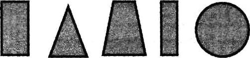
buoy conical buoy
pillar buoy spar buoy spherical buoy (cone) (sphere)
Exercise 5. Answer
the questions
1.
What buoyage systems are employed
worldwide?
2.
What are buoys in the Lateral system
used to indicate?
3.
What subsystems is the Lateral
system subdivided into?
4.
How is the starboard side of the
fairway indicated in the A-system?
5.
How is the port side of the fairway
indicated in the A-system?
6.
What subsystem is employed in
America and some oriental countries?
7.
What are buoys in the Cardinal
system used to indicate?
8.
How is the position of the danger
indicated?
9.
What will give the navigator
information regarding the vessel's position in reference to the position of the
danger?
10.
What colour light are special buoys
fitted with?
11.
What do landfall marks mark?
12.
What colour light are isolated
danger marks fitted with?
13.
Where can you read about buoys and
beacons?
Exercise 6. Find in
the text the English equivalents for the following words and expressions
1.
основные
системы ограждения буями
2.
латеральная
система ограждений
3.
кардинальная
система ограждений
4.
конус
красного цвета
5.
цилиндр
зелёного цвета
6.
лоция
7.
достаточная
глубина
8.
подходы
к побережью
9.
правая
сторона фарватера
10.
информация
относительно местоположения судна
11.
местонахождение
опасности
12.
восточные
страны
13.
указывать
Exercise 7. Watch
the International Maritime English Programme (Lectures. Buoyage) and get
acquainted with the Lateral and Cardinal Buoyage System) Listen, take notes,
and draw in colour Cardinal Buoys and Cardinal Buoyage around a wreck8. Outline
their main characteristics
PART3
9. Scan the
text(Daymarks)are not only distinguished by their shapes and colours, but also
by their topmarks (daymarks). The shapes of these topmarks may be a can, a
cone, a sphere or a cross.pillar- or spar- buoys are fitted with red or green
can-shaped or conical topmarks. When the buoys are can- or conical-shaped
themselves they are not fitted with any topmarks.buoys are fitted with two
black cones.is indicated by two cones points up;is indicated by two cones
points down;is indicated by two cones point to point;is indicated by two cones
base to base.special buoy, whose meaning is indicated in the pilot book,
carries a yellow cross.safe water buoy (landfall buoy) is fitted with a single
red sphere.isolated danger buoy carries two black spheres.10. Watch the
International Maritime English Programme ((Lectures. Topmarks) and get
acquainted with the Lateral and Cardinal Buoyage System) Listen, write down,
draw in colour and outline the main characteristics
a)
of the Lateral buoys;
b)
of the Cardinal buoys;
Be ready to
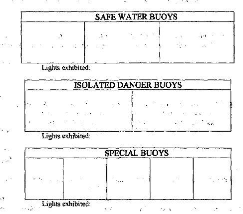
describe orally any of them and answer the following questions11. Complete the
chart
|
CARDINAL SYSTEM
|
IALA-A SYSTEM
|
IALA-B SYSTEM
|
|
|
Picture
|
Features
|
Picture
|
Features
|
Picture
|
Features
|
|
|
|
Shape:
|
|
|
Shape:
|
|
Shape:
|
|
|
|
Colour:
|
|
|
Colour:
|
|
Colour:
|
|
|
I
|
|
Topmarks:
|
|
|
Topmarks:
|
|
Topmarks:
|
|
|
NORTH BU
|
|
Light:
|
|
|
Light
|
|
Light:
|
|
|
|
|
|
W
|
|
Number:
|
|
Number-
|
|
|
|
|
|
|
|
Shape:
|
|
Shape •
|
|
|
|
|
|
Ч
|
|
Colour:
|
|
Colour:
|
|
|
|
|
(SB)STARBa
|
|
Topmarks: Light:
|
|
Topmarks: Light:
|
|
|
|
Shape:
|
|
|
|
|
|
|
|
H BUOYS
|
|
Colour: Topmarks:
Light:
|
|
|
Number:
|
|
Number:
|
|
|
|
|
|
|
|
Shape: Colour:
|
|
Shape: Colour:
|
|
|
8
|
|
|
|
• !
|
• Topmarks: Light: Number:
|
|
Topmarks: Light
Number
|
|
|
WEST BUOYS !
|
|
Shape Colour: Topmarks: Light.
|
PORT SIDE |
|
|
Shape: Colour: Topmarks. Light:
Number:
|
|
Shape: Colour: Topmarks. Light:
Number:
|
|
|
|
|
|
|
Shape. Colour: Topmarks: Light:
Number
|
|
Shape. Colour Topmarks: Light.
Number:
|
|
EAST BUOYS
|
|
Shape: Colour: Topmarks. Light:
|
|
|
|
|
|
|
|
|
|
|
|
Shape: Colour: Topmarks. Light.
Number
|
|
Shape: Colour. Topmarks Light:
Number:
|
|
|
|
|
|
|
|
|
|
|
|
|
|
|
Exercise 12. Answer
the following questions
1.
What systems is the buoyage system
divided into?
2.
What is the lateral system used for?
3.
What is the Cardinal system used
for?
4.
How are the North Cardinal buoys
indicated?
5.
How are the South Cardinal buoys
indicated?
6.
How are the West Cardinal buoys
indicated?
7.
How are the East Cardinal Buoys
indicated?
8.
What information does a pillar buoy
provide itself?
9.
What are the Yellow Spherical buoys
used for?
10.
What are the spherical buoys painted
in vertical stripes used for?
11.
How is direction of the ship marked
in a I ALA -A system?
12.
What are the odd numbers used for in
a Lateral System?
13.
What are the even numbers used for
in a Lateral System?
14.
What lights may be exhibited from
Lateral buoys?
15.
What are the cardinal colours? What
do they mean? Draw the picture.
16.
What lights are used on Safe water
buoys?
РАНТ
413. Read the paragraphs from Pilot - book and translate them into lussian
1.
There are three buoys in the harbour
marking the channel.
2.
A red bell buoy with a staff is
moored close off the north-eastern extremity )fDoboy.
3.
A black nun buoy is placed at the
western end of the channel in a depth of 15 feet. Vessels must pass northward
of it
4.
A black spar buoy, with conical
topmark, is moored in a depth of 10 feet, on he shoal extending off the western
entrance point of the bay.
5.
A green wreck buoy lies close
eastward of the black beacon buoy and on he south side of a sunken wreck, on
which there is a least depth of 26 feet.
6.
A red spar buoy, surmounted by a
ball, is moored in a depth of 5 V2 feth-Dms, at 6 cables eastward from the old
lighthouse, to mark the extremity of the -ocky ledge extending in that
direction.
7.
A can buoy and red spar buoy lie on
the south-eastern side of the shoals on he northern side of the approach, at a
distance of 16 miles, 82° true, from Zumber Lighthouse.
8.
A spherical buoy painted in black
and white horizontal stripes, surmounted by an iron staff and cross, lies close
south-eastward of Cabretta.
9.
A black spindle buoy with cylindrical
topmark is moored off the extreme of the shallow ree£ extending about 1
/3 cables southward from rocky ledges, one of which
dries 9 feet.
10.
A pillar shaped whistle buoy,
painted in black and white horizontal bands, marked "L. P.",
surmounted by a staff, and exhibiting a white occulting light is placed in 12 fathoms
about 1V4 miles north-eastward of the northern extremity of Tybee Bank.
11.
A black and red vertically striped
conical buoy marked "S. M.", with a topmark consisting of a cone
point down surmounted by a cross, is established off the entrance to Stingray,
and about l3/4 miles eastward of Saldera light-and-whistle buoy.
12.
The fairway buoy, situated about 4
miles north-westward of Cora Lighthouse, is a red and black chequered conical
buoy with a topmark consisting of a double cross over a cone point down. No. 1
red and No. 2 black, situated about 8 cables southeastward of the fairway buoy
have a cage and a truncated cone topmark respectively.
13.
A light-buoy, exhibiting a fixed red
light, established southward of Auts Bank in a position about 13/4 miles
east-north-eastward of Colpoys Point. A light-buoy exhibiting a fixed green
light is established near the anchorage in a position about 5 cables
north-north-eastward of Range Point. The position of the light buoys are not to
be depended upon.
14.
In difficult parts of the river the
channel is marked by red conical and black can buoys; during winter they are
replaced by spar buoys. Red buoys indicate that the channel lies between them
and the right bank and they must therefore be left on the starboard hand by
vessels proceeding up-river.
15.
A light-and-bell-buoy, with red and black
horizontal bands, and showing a short white flash every two seconds, is moored
on the north-eastern side of Potter Rock.
16.
California Rock, small in extent,
with a depth of 9 feet over it, lies nearly in mid-channel in the passage
north-eastward of Pennock Island, about half a mile northward of the
south-eastern extremity of the island. It is marked on its northeastern side by
a black barrel shaped buoy with a topmark consisting of a cone point down.
17. A
light-and-whistle-buoy, painted red, marked No. 2, exhibiting a white flashing
light of one second's duration every ten seconds, is moored about 3 cables
south-south-westward of Harwell Island.
I. A red beacon
stands on the northern side of the shoal. 2. A red conical beacon stands on the
edge of the reef extending about half a mile south-westward of Felice. 3. A
beacon marks the edge of the reef extending northward from the southern
entrance point of the bay. 4. A beacon, the position of which is approximate,
stands near the northern end of the reef on the western side of the entrance.
5.
A red beacon, surmounted by a cone,
marks the outer end of a reef which extends about 4V2 cables west-south-westward
from Clover, the eastern entrance point.
6.
Too much reliance should not be
placed on the existence of beacons in the vicinity.
7.
The southern patch has a least depth
of 3 fathoms and is marked on its north-western side by a black conical buoy,
surmounted by a cylinder.
8.
A white triangular beacon stands on
the eastern shore of Higgins Channel 2 V4 miles north-eastward of Betton Point.
9.
A beacon surmounted by a white disc,
stands on the southern shore, which, in line with a rock, painted white, bearing
172°, leads to the anchorage.
10.
A red beacon is situated on the
southern side of the fairway, three-quarters of a mile eastward of the
north-western extremity of the reef on the southern side of the entrance.
11.
Two white, square leading beacons,
the front one of which is a stone tower, standing at elevations of 164 and 184
feet, respectively, are situated on the northern side of the port.
12.
On the northern extremity of the
north-western islet is a white pyramidal beacon 13 feet high, surmounted by a
cross, and on the south-eastern islet is a similar beacon surmounted by an
inverted cone and a cross. These beacons in line bearing 105°, lead through the
channel southward of Larzatita Island, situated about a mile west-north-westward.
13.
A white square framework beacon, 29
feet high, stands on the southwestern side of the bay, about a quarter of a
mile westward of the light structure. A white framework beacon surmounted by a
cylinder, 31 feet high, stands on the same side, 4 V2 cables north-westward of
the first beacon.
Exercise 14.
Translate the following sentences into Russian
(A.) 1. A pillar
shaped whistle buoy.
2.
A black barrel shaped buoy.
3.
A ball topmark.
4.
A diamond shaped topmark.
5.
An entrance point.
6.
A fairway buoy.
(B.) 1. The
position of the light-buoy is not to be depended on (upon). 2. Too much
reliance should not be placed ...15. Form verbs from the following nouns and
translate both the nouns and the verbs, bearing, breaker, leader, situation,
cross, mark, anchorage.16. Give synonyms to, shoal, starboard, ledge, to
proceed, left.17. Give antonyms to, outer, far, here, less, difficult, always,
much, horizontal, foul ground, shallow water.18. Translate the following
sentences into English
1.
Этот
буй окрашен в красный цвет.
2.
Должны
мы оставить этот буй с правого или левого борта?
3.
На
освещаемый береговой знак нельзя по лататься.
4.
Белый
конический буй, увенчанный шаром, установлен на глубине 10 футов.
5.
Чёрный
тупоконечный буй, расположенный около 4 миль к северо-западу от маяка К.,
отмечает северную сторону мели.
6.
С
какой стороны следует пройти этот буй?
7.
Вы
можете пройти этот буй с любой стороны (с левой, с правой стороны).
8.
Восточная
сторона фарватера ограждена красным береговым знаком.
9.
Белый
треугольный береговой знак стоит на северной стороне мели.
10.
Этот
береговой знак, увенчанный конусом, расположен в 3 /г милях от берега.
11.
Скала
глубиной менее двух футов отмечена белым береговым знаком.
12.
Что
ограждают эти буи? Эти буи ограждают мель.
13.
Как
ограждена мель? Мель ограждена вехами.
14.
Имеются
ли там швартовные бочки?
15.
Нет,
там нет швартовных бочек.
Exercise 19. Read
the following fractions in English
20. Read and
translate. Check your translations by finding the corresponding point in
Russian
|
1. A spherical buoy, painted in
white and green horizontal bands and surmounted by a staff, is moored about
2lU cables south ward of the eastern extremity of the Nome. 2. A can buoy,
painted in red and white che quers, marks the extremity of Peveril ledge.
|
a)
Светящийся буй (конический зелёный проблесковый огонь с периодом проблеска 5
секунд) ограждает восточную сторону мели с наименьшей глубиной 3,0 м (10
футов), на западной стороне которой на ходится затонувшее судно с четырьмя
мачтами, высотой 12 м. b) Бочкообразный буй, раскрашенный в красную и белую
клетку с топовой фигу рой, установлен в полумиле на северо- восток от
светящейся башни, во время се веро-западного муссона он устанавлива ется как
раз на банке, а во время юго-
|
|
3. Three small red barrel buoys,
used when launching and mooring the lifeboat, lie northward of the lifeboat
slipway about lV2 cables eastward of the pier. 4. Two black spherical mooring
buoys for the use of the lighthouse tender are moored at distance of one and
2lh cables, respect tively, from Wolf Rock. 5. A pillar light
whistle-and-bell buoy, painted red and exhibiting a white group flashing
Light showing two flashes every ten seconds is moored about 21/* cables
southward of Runnel Stone; the bell is ac tuated by wave motion. The buoy is
liable to drift or break away, so no reliance can be placed on its being in
position. 6. A conical light-buoy, No 2D, painted yel low with red vertical
stripes, and exhibiting a red flashing light every ten seconds, is moored
about 2V2 miles eastward of Nare point. 7. A red and white chequered can
buoy, with a cylindrical topmark marks the southern side of a shoal situated
about 11 cables westward of the summit of St. Anne island. 8. A red and white
chequered barrel buoy with a topmark is moored about half a mile
north-eastward of the light tower; during the north-west monsoon it is moored
just on the bank, and during the south-east monsoon just off the southern
side of the bank. 9. A light-buoy (conical green; light-flashing green every
five seconds) marks the E side of a shoal with a least depth of 3,0 m (10
feet), on the W side of which there is a wreck with four masts, 12 m high.
|
восточного
- мористее южной стороны банки. c) Цилиндрический буй, окрашенный в красную и
белую клетку с цилиндрической топовой фигурой, ограждает южную сторону
отмели, расположенную около 11 кабельтовых западнее острова Святой Анны. d)
Конический светящийся буй, номер 2Д, окрашенный в жёлтый цвет красными
вертикальными полосами, показывающий красный ггооблесковый огонь каждые 10
секунд, установлен около 2,5 миль восточнее мыса Наре. e) Столбообразный
светящийся со свистком и колоколом буй, окрашенный в красный цвет и
показывающий группо-проблесковый огонь с двумя проблесками каждые 10 секунд,
установлен около двух с четвертью кабельтовых к югу от Рунел Стоун; колокол
звенит от движения воды. Буй подвержен дрейфу или смещению, поэтому нельзя
полагаться на его поло жение. f) Два чёрных сферических
швартовых буя для использования маячного тендера (по сыльного судна)
установлены на расстоя нии одного и двух с половиной кабельто вых
соответственно от скалы Вульф. g) Три маленьких красных
бочкообразных буя, используемых для спуска на воду и швартовки спасательной
шлюпки, нахо дятся севернее от судоподъёмного эллин га около 1,5 кабельтовых
к востоку от пирса. h) Цщиндрический буй,
окрашенный в красную и белую клетку, ограждает восточную оконечность рифа
(гряды камней) П. i) Сферический буй, окрашенный в
белые и зелёные горизонтальные полосы, и увенчанный вехой, установлен в 2,25
кабельтовых к югу от восточной оконечности Нове.
|
|
|
|
|
|
Buoys and beacons
|
В.,
Blk.
|
Black
|
Чёрный
|
|
Cheq.
|
Chequered
|
Шахматной
окраски
|
|
G.
|
Green
|
Зелёный
|
|
Gy.
|
Grey
|
Серый
|
|
H. S.
|
Horizontal stripes
|
Горизонтальные
полосы
|
|
R.
|
Red
|
Красный
|
|
v,s.
|
Vertical stripes
|
Вертикальные
полосы
|
|
Y.
|
Yellow
|
Жёлтый
|
|
W.
|
White
|
Белый
|
Abbreviations
Bottom
|
b.
|
Blue
|
Синий
|
|
Ms.
|
Mussels
|
Ракушки,
|
|
ы.
|
Black
|
Чёрный
|
|
|
|
моллюски
|
|
bk.
|
Broken
|
Битый
|
|
|
Оу.
|
Oysters
|
Устрицы
|
|
br.
|
Brown
|
Коричневый
|
|
|
Oz.
|
Ooze
|
Жидкий
ил,
|
|
с.
|
Coarse
|
Крупный
|
|
|
|
|
тина
|
|
ca.
|
Calcareous
|
Известковый
|
|
|
Р.
|
Pebbles
|
Крупная
галька
|
|
Ck.
|
Chalk
|
Мел
|
|
|
Рш.
|
Pumice
|
Пемза
|
|
ch.
|
Chocolate
|
Шоколадный
|
|
|
Qz.
|
Quartz
|
Кварц
|
|
|
цвет
|
|
|
R.
|
Rock
|
Скала
|
|
Cn.
|
Cinders
|
Зола
|
|
|
Rd.
|
Radiolarian
|
Радиолярий
|
|
Cy.
|
Clay
|
Глина
|
|
|
rd.
|
Red
|
Красный
|
|
Co.
|
Coral
|
Коралл
|
|
|
S.
|
Sand
|
Песок
|
|
d.
|
Dark
|
Тёмный
|
А
|
Sc.
|
Scoria
|
Шлак
|
|
f.
|
Fine
|
Мелкий
|
|}
|
so.
|
Soft
|
Мягкий
|
|
G.
|
Gravel
|
Гравий
|
у
|
Sh.
|
Shells
|
Ракушки
|
|
Gd.
|
Грунт
|
|
|
Sn.
|
Shingle
|
Галька
|
|
Gl.
|
Globigerina
|
Глобигерина
|
|
|
sm.
|
Small
|
Маленький
|
|
ga-
|
Glacial
|
Ледниковый
|
|
|
Sp.
|
Sponge
|
Губка
|
|
ga-
|
Green
|
Зелёный
|
|
|
sk.
|
Specks, speckled
|
Пятнистый
|
|
gy-
|
Gray
|
Серый
|
|
|
St.
|
Stones
|
Камни
|
|
h.
|
Hard
|
Твёрдый
|
|
|
sf.
|
Stiff
|
Жёсткий
|
|
It.
|
Light
|
Светлый
|
|
|
sy.
|
Sticky
|
Вязкий
|
|
Lv.
|
Lava
|
Лава
|
|
|
T.
|
Tufa
|
Туф
|
|
M.
|
Mud
|
Ил
|
|
|
V.
|
Volcanic
|
Вулканический
|
|
Mn.
|
Manganese
|
Марганец
|
|
|
w.
|
White
|
Белый
|
|
Ml. i
|
Marl
|
Мергель
|
|
Wd. У-
|
Weed Yellow
|
Водоросли
Жёлтый
|
UNIT 7. DANGERS
PART
I. Vocabulary and reading
these words and
expressions orally and learn them by heart
 Bank - отмель,
банка
P* Drying b. - осушная
банка
P^ Bar - бар, отмель
P** Cliff- утёс> Cluster
of rocks - группа скал
P* Flat - отмель P5"
Ledge - гряда
рифов»-
Patch - группа банок,
группа камней; отличительная глубина; участок Р* Reef
- риф Bank - отмель,
банка
P* Drying b. - осушная
банка
P^ Bar - бар, отмель
P** Cliff- утёс> Cluster
of rocks - группа скал
P* Flat - отмель P5"
Ledge - гряда
рифов»-
Patch - группа банок,
группа камней; отличительная глубина; участок Р* Reef
- риф
ЧЬ* Ridge
- подводная гряда, гребень Р* i?ocA:
- скала
Р" Above
water r.
- надводная скала Р^ Below
water r.
- подводная скала Р^ Drying
г. - осыхающая скала Р** ///#/* uw/er
г. - надводная скала Р* Low
wafer r.
- подводная скала Р^ Pinnacle
r. - остроконечная
скала ^ Submerged
г. - подводная скала Р>- Sunken
г. - подводная скала Р" Under
water r.
- подводная скала Р=" Shallow
- мель; мелкий, мелководный 9* s.
water - мелководье 9* shoal
- мель; отмель; мелеть; мелкий
·
attached s. - примыкающая
мель
·
detached s. - отдельно
лежащая мель
·
8. head- коса,
риф
·
s. water - мелководье
Р*
Spit - коса
Р=" Wreck
- затонувшее судно
Р* Го encounter-
встречаться с чем-либо
Р=* Го threaten
- угрожать
Р" Safety
- безопасность
Р*- Fas*
ice - сплошной твёрдый
лёд
Words and word
combinations concerning buoys and beacons* Awash
- омываемый водой
£*- To
break - ломать,
разрушать, образовывать буруны
Breakwater
- бурун, прибой ^ Clear
- ясный, чистый; пройти не задев ft*
Danger опасность ft"
Dangerous - опасный ft"
Learf *%?//? -
наименьшая глубина ft5*
Prudent - осторожный, зд.
на большом расстоянии ft*
one fathom
patch - односаженная
отличительная глубина ft*
5-fathom line
- 5-саженная линия (равных глубин) - изобата ft*
clearing
marks - створные знаки,
ограждающие опасности ft*
off- shore
dangers - отдалённые от
берега (мористые) опасности ft"
off the
coast ofX.
- мористее побережья X.
ft* to
be in
danger - быть
(находиться) в опасности ft*
to be
out of
danger - быть вне
опасности ft" to
be clear
of danger
быть свободным от опасности ft5"
to pass
clear of-
пройти в стороне от ft*
to keep
clear of-
держаться в стороне от ft"
to close
the land
приближаться к берегу
ft"
to give
a wide
berth - пройти в
достаточном (безопасном) расстоянии ft8"
as much
as ... 2 miles
- на расстоянии 2 миль ft*
in line
with T.
bearing 41° - в створе с
Т. по пеленгу 41° ft*
under 11 fathoms
- менее 11 морских саженей ft*
well off..
the pier
- на значительном расстоянии от пирса ft*
vessels drawing
20 feet of
water - суда с осадкой
20 футов
Memorize the
translation of the following sentences" There is a danger due to mines
there. - Там имеется
опасность
от
мин."
This rock must be given a wide berth. - Эту
скалу
надо
обойти
на
большом
расстоянии.*
These rocks must be given a berth of 2 cables. - Эти
скалы
надо
обойти
на
расстоянии
2 кабельтовых.*
Т.
danger with 4 feet (water over it) lies about 3 miles south-eastward ofM. - Опасность
Т.на
глубине
4 фута
находится
около
3 миль
к
юго-востоку
от
М."
T in a depth of 5 fathoms lies about 51miles westward ofN. Island.
- Т. на глубине 5 саженей лежит около 51 мили к западу от острова Н.
ft* This coast must
be approached with great caution. - К
этому
берегу
надо
подходить
с
большой
осторожностью.I.
Read the text and answer the following questionsare many dangers which the
navigator may encounter. Banks, patches, underwater rocks, shallow waters may
threaten the ship's safety. When navigating in dangerous areas the navigator
should avoid all these dangers.a rule, all the dangers are shown on the charts.
They are also described in pilot-books. That's why pilot-books and charts
should always be carefully consulted.in the Northern seas is especially
dangerous, because of ice. In the open sea ships can meet floating ice
formations. Fast ice is often found over shoals. Icebergs broken away from the
parent formation may float in the open sea. Ice formations may prevent the
ship's movement. They make the navigator sometimes change course and speed.
When sailing in dangerous areas a sharp look-out should be always kept.
1.
What dangers may threaten the ship's
safety?
2.
What book should a navigator consult
to avoid dangers?
3.
Why is navigation especially
dangerous in the North?
4.
Why is the ice in bays more
dangerous than in the open sea?
5.
What do we call ice formations
attached to the shore?
6.
Where is fost ice found?
7.
What makes sometimes the navigator
change the ship's course in the Northern seas?
8.
When is it especially recommended to
keep a sharp look out?
Exercise 2.Find the
corresponding English equivalents in the text
1.
могут
столкнуться
2.
угрожать
безопасности судна
3.
следует
избегать
4.
как
правило
5.
описываются
в лоциях
6.
следует
тщательно консультироваться
7.
из-за
льда
8.
сплошной
лёд
9.
менять
курс и скорость
2
3. Listen to SMCP
on navigational warnings and repeat them. Learn them by heart. Record your own
voice. Replay the original and your own version
|
There is a dangerous wreck in
position ... (marked by ... showing ...)
|
Опасное
затонувшее судно в точке ... (ограждено ... показывающим)
|
|
|
There is a dangerous rock in
position (marked by ... showing ...)
|
Опасная
скала в точке ... (ограждено ... показывающим)
|
|
|
There is a dangerous shoal in
position (marked by ... showing...)
|
Опасная
мель в точке ... (ограждено ,.. показывающим)
|
|
|
There is a drifting mine reported
in position
|
По
сообщению, дрейфующая мина в точке...
|
|
|
There is a gas leakage (from
fractured pipeline) in position
|
Наблюдается
утечка газа (из трубопровода) в точке ...
|
|
There is a slick of oil in
position (extending)
|
Нефтяное
пятно в точке .. (простирается)
|
|
There are pipelaying operations in
position
|
Проводятся
работы по прокладке трубопровода в ...
|
|
There are cablelaying operations
in position
|
Проводятся
работы по прокладке кабеля в ...
|
|
There are salvage operations in
position
|
Проводятся
спасательные работы в ...
|
|
There are oil clearance operations
in position
|
Проводятся
операции по очистке нефти в ...
|
|
There are tankers transferring...
in position
|
Танкеры,
передающие... находятся в точке...
|
|
There are current metres moored in
position
|
Измерители
скорости течения установлены на якорь в точке ...
|
|
There are oceanographic
instruments moored in position ...
|
Океанографические
приборы установлены на якорь в точке ...
|
|
There is a derelict adrift in
position ... (at ... hours)
|
Покинутое
судно дрейфует в точке ... (в ... часов)
|
|
There is a vessel with a difficult
tow on passage from .. to ...
|
Судно,
занятое сложной буксировкой, находится на переходе из ... в ...
|
|
There is a drilling rig ... (name)
established in position ...
|
Буровая
платформа установлена в точке
|
|
There is an off-shore
installation... (name) established in position
|
Морское
сооружение... установлено в точке...
|
|
There is a ... buoy in position
... unlit
|
В
точке ... находится несветящийся буй
|
|
There is another mark in position
... unlit
|
В
точке ... находится другой несветящийся знак ...
|
|
There is a ... buoy in position
... off station
|
В
точке ... находится смещенный со своего штатного места буй
|
|
There is another mark in position
... off station
|
В
точке ... находится смещенный со своего штатного места другой знак
|
|
There is a ... buoy (showing ...)
established in position ...
|
Буй
(показывающий) установлен на штатном месте в точке ...
|
|
"here is another mark
(showing ...) estab-shed in position ...
|
Другой
знак (показывающий ...) установлен на штатном месте в точке ...
|
|
|
'here is a ... light in position
... now howing
|
Огонь
... в точке ... сейчас показывает
|
|
|
'here is a ... buoy in position
... now howing
|
Буй
... в точке ... сейчас показывает
|
|
|
"here is another mark in
position ... now howing
|
Другой
знак ... в точке ... сейчас показывает
|
|
|
There is a vessel carrying out
hydrographic ;urvey in position
|
Судно
производит гидрографические исследования в точке ...
|
|
|
There is a vessel carrying out
seismic survey in area
|
Судно
производит сейсмические исследования в районе ...
|
|
|
Abnormally low tides expected in
... at... lours
|
Необычно
низкие отливы ожидаются в ... в ... часов
|
|
|
Abnormally low tides expected in
... around... hours
|
Необычно
низкие отливы ожидаются в ... около ... часов
|
|
|
Vessels must keep clear of area
indicated
|
Суда
должны проходить в стороне от указанного района
|
|
|
Vessels are advised to keep clear
of this area
|
Судам
рекомендуется проходить в стороне от этого района
|
|
|
Vessels must navigate with caution
|
Суда
должны идти с осторожностью
|
|
|
There is a vessel not under
command in position
|
В
районе находится судно, лишенное возможности управляться
|
|
|
There is hampered vessel in
position
|
В
точке ... находится судно, ограниченное в возможности маневрировать
|
|
|
Radio beacon service ... has been
discontinued
|
Радиомаяк
...
прекратил
работу
|
|
|
Advise you keep clear of sea
area... search and rescue in operation
|
Советую
Вам держаться в стороне от морского района ..., где проводится операция по
поиску и спасению
|
|
|
Route ... has been suspended
|
Путь
...
временно
закрыт
|
|
|
Traffic lane ... has been
suspended
|
Полоса
движения ...
временно
закрыта
|
|
|
Route ... has been discontinued
|
Путь
...
отменен
|
|
|
Traffic lane ... has been
discontinued
|
Полоса
движения ...
отменена
|
|
|
Route has been diverted
|
Путь
...
изменен
|
|
|
Traffic lane ... has been diverted
|
Полоса
движения ...
изменена
|
|
|
|
|
|
|
|
|
4. Match the words
from the left column with the words from the right column
|
1. range scale 2. to suspend 3.
identification 4. a slick of oil 5. pipelaying operations 6. off station 7.
oil clearance operations 8. gas leakage 9. hampered vessel lO.hydrographic
surveys 11 .current metres 12.seismic surveys 13.abnormally low tides 14.on
passage from... to... 15oceanographic instrument 16.traffic lane 17 to
discontinue 18. radar contact 19. salvage operations 20. cablelaying
operations
|
a.
гидрографические исследования b. операции по очистке нефти
c. работы по прокладке трубопровода d. спасательные
операции e. шкала дистанций f. измерители скорости
течения g.
сейсмические исследования п. необычно низкие отливы i. на
переходе от... до... j. радиолокационный контакт
к. океанографические приборы 1. опознавание т. отменить п. операции по укладке
кабеля о. нефтяное пятно р. смещенный со штатного места q. временно
закрыть г. утечка газа s. судно, ограниченное в
возможносп маневрировать t. полоса движения
|
J. Listen to the
SMCP again and fill in the gaps using appropriate terms
|
There is a
|
dangerous
|
.... in position... (marked by...
showing...)
|
|
There is a
|
dangerous rock....
|
(markedby... showing...)
|
|
There is ..
|
|
.... in position (marked by...
showing...)
|
|
|
.... reported in position...
|
|
There is ,
|
|
.... (from fractured pipeline) in
position
|
|
|
|
|
There is a
|
|
in position(extending)
|
|
|
|
|
|
There are
|
|
operations in position
|
|
There are
|
|
operations in position
|
|
There are salvage
|
|
|
|
. operations in position
|
|
|
|
|
|
.. moored in position
|
|
|
There are oceanographic
|
moored in position...
|
|
|
There is a
|
adrift in position... (at...
hours)
|
|
|
There is a vessel with a
|
on passage from... to...
|
|
|
There isa
|
(name) established in position...
|
|
|
There is an off-shore
|
(name) established in position
|
|
|
There is a... buoy in position...
|
|
|
|
|
|
|
|
There is another
|
in position...unlit
|
|
|
There is a... buoy in position...
|
|
|
|
|
|
|
|
There is mark in position... off
station
|
|
|
There is a... buoy (showing...) .
|
in position...
|
|
|
There is another mark (
|
) established in position...
|
|
|
There isa
|
in position... now showing
|
|
|
|
|
|
There is
|
in position... now showing
|
|
|
There is a vessel carrying out .
|
in position
|
|
|
There is a vessel carrying out..
|
|
|
|
Abnormally low tides
|
in... at... hours
|
|
|
Abnormally low tides expected
|
in hours
|
|
|
area indicated
|
|
|
Vessels
|
|
|
|
Vessels must navigate
|
|
|
|
|
There is a vessel
|
in position
|
|
|
There is
|
vessel in position
|
|
|
Radio beacon service
|
discontinued
|
|
|
Advise you keep clear of sea area
in operation
|
|
Route... has been
|
|
Traffic has been suspended
|
|
has been discontinued
|
|
Route diverted
|
|
Traffic lane... has been
|
6. Listen to SMCP
on dangers to navigation, warnings and assistance and learn them by heart.
Record your own voice. Replay the original and your own version
|
You are running into danger
|
Вы
идёте к опасности
|
|
Shallow water ahead of you.
|
Впереди
Вас мель.
|
|
Submerged wreck ahead of you.
|
Впереди
Вас скрытое под водой затонувшее судно.
|
|
Risk of collision imminent.
|
Имеется
риск столкновения.
|
|
Fog bank ahead of you.
|
Впереди
полоса тумана.
|
|
Bridge will not open.
|
Мост
не будет открыт.
|
|
Dangerous obstruction reported
at...
|
Сообщается
об опасном препятствии в
|
|
Unknown objects) in position ...
|
Неопознанный
объект (объекты) находится (находятся) в точке ...
|
|
Floating ice in position...
|
Дрейфующий
лёд находится в районе
|
|
(considered hazardous to
navigation).
|
(представляющий
опасность для навигации).
|
|
Mine(s) reported in position...
|
По
сообщению, в точке ... замечена мина (мины).
|
|
Navigation is closed (prohibited)
in area...
|
Судоходство
закрыто/запрещено в районе ...
|
|
There has been a collision in
position...
|
В
точке ...
произошло
столкновение ...
|
|
Stand by to give assistance.
|
Будьте
готовы оказать помощь.
|
|
It is dangerous to ...
|
Опасно...
|
|
|
Stop
|
Останавливаться
|
|
|
Remain in present position
|
Оставаться
на прежнем месте
|
|
|
Alter course to starboard
|
Изменять
курс вправо
|
|
|
Alter course to port
|
Изменять
курс влево
|
|
|
Approach close to my vessel
|
Приближаться
вплотную к моему судну
|
|
|
Vessel... is aground... in
position...
|
Судно
... на мели в точке ...
|
|
|
Vessel... is on fire in position...
|
Пожар
на судне ... в точке...
|
|
|
Large vessel leaving.
|
Отходит
большое судно.
|
|
|
Keep clear of approach channel.
|
Держитесь
в стороне от подходного канала.
|
|
|
Go to Emergency anchorage.
|
Следуйте
на аварийную/запасную якорную стоянку.
|
|
|
Your navigation lights are not
visible.
|
Ваши
ходовые огни не видны.
|
|
|
You are running aground.
|
Вы
идёте на мель.
|
|
|
Keep clear. I am jettisoning
dangerous cargo.
|
Держитесь
в стороне. Я сбрасываю опасный груз.
|
|
|
Vessel is leaking inflammable
cargo in position...
|
Судно
в точке ... имеет утечку воспламеняющегося груза.
|
|
|
Vessel is leaking noxious cargo in
position...
|
Судно
в точке... имеет утечку вредного груза.
|
|
|
Vessel is leaking poisonous cargo
in position...
|
Судно
в точке,.. имеет утечку ядовитого груза.
|
|
|
I have a long tow.
|
У
меня длинный буксир.
|
|
|
You are crossing my nets.
|
Вы
идёте на мои сети.
|
|
|
You are heading towards my tow/a
towing line.
|
Вы
идёте прямо на буксируемый объект/буксирный трос.
|
|
|
You are heading towards towing
line.
|
Вы
идёте прямо на буксирный трос.
|
|
|
I need help...
|
Я
нуждаюсь в помощи...
|
|
|
I am sinking.
|
Я
тону.
|
|
|
I will make a lee for... your
vessel the boat the raft
|
Я
прикрою от ветра... Ваше судно шлюпку плот
|
|
|
I cannot send a boat.
|
Я
не могу выслать шлюпку.
|
|
|
I cannot send a raft.
|
Я
не могу выслать плот.
|
|
|
I will attempt rescue by Breeches
buoy.
|
Я
попытаюсь использовать спасательную беседку.
|
|
|
Is it safe to fire a rocket? It is
safe to fire a rocket. It is not safe to fire a rocket.
|
Безопасно
ли будет выстрелить ракету? Выстрелить ракету неопасно. Выстрелить ракету
небезопасно.
|
|
|
Take command on search and rescue.
|
Примите
командирование поиском и спасением.
|
Судно
... руководит поиском и спасением.
|
|
|
I am in command of search and
rescue.
|
Я
руковожу поиском и спасением.
|
|
|
Assistance is no longer required.
|
Помощь
больше не нужна.
|
|
|
You may proceed.
|
Вы
можете следовать дальше.
|
|
|
You must keep radio silence in
this area unless you have messages about the casualty.
|
Вы
должны соблюдать радиомолчание в этом районе, если только у Вас нет сообщения
о несчастном случае.
|
|
|
|
|
|
|
|
7. Match the words
from the left column with the words from the right column
|
1. ahead of you
|
а.
подходной канал
|
|
|
2. reported
|
b. вредный груз
|
|
|
3. hazardous to navigation
|
с.
аварийная якорная стоянка
|
|
|
4. remain
|
d. держаться в стороне от...
|
|
|
5. approach channel
|
е.
идти прямо на...
|
|
|
6. keep clear
|
f. дрейфующий лед
|
|
|
7. noxious cargo
|
g. Я руковожу поиском и
|
|
|
спасением
|
|
|
8. make a lee
|
h. препятствие
|
|
|
9. to head towards
|
i. сообщается
|
|
|
10. in the living spaces
|
j. воспламеняющийся груз
|
|
|
11.1 am in command of searh and
rescue
|
к.
прикрыть от ветра
|
|
|
12. to keep radio silence
|
1. видимые огни
|
|
|
13.1 am sending you a boat
|
т.
в жилых помещениях
|
|
|
14. large vessel leaving
|
п.
оставайтесь
|
|
|
15.1 am aground 16. Emergency
Anchorage 17. floating ice 18. obstruction 19. inflammable cargo 20. visible
lights
|
о.
опасно для навигации p. Я высылаю Вам шлюпку q. Я на
мели, г. соблюдать радиосвязь s. отходит большое судно t впереди
|
|
|
|
|
8. Listen to the
SMCP again and fill in the gaps using appropriate terms
|
You are running into danger
|
|
|
ahead of you.
|
|
|
|
|
ahead of you.
|
|
|
|
|
Risk of collision
|
|
|
|
|
ahead of you.
|
|
|
|
|
Bridge will not open.
|
|
|
renorted at...
|
|
|
|
|
Unknown objects) in position ...
|
|
|
in position...
|
|
|
|
|
(considered
|
to navigation).
|
|
|
Mine(s) reported in position...
|
|
|
Navigation is closed (
|
)inarea...
|
|
|
There has been a
|
in position...
|
|
|
|
|
|
|
It is dangerous to ...
|
|
|
Remain in present position
|
|
|
|
Alter course to
|
|
|
|
|
|
|
Approach
|
to my vessel
|
|
|
Vessel... is
|
in position...
|
|
|
|
|
Large vessel leaving.
|
|
|
|
|
|
|
Your navigation lights are not
|
|
|
You are running aground.
|
|
|
Keep clear. I am jettisoning
dangerous cargo.
|
|
|
|
|
Vessel is leaking noxious cargo in
position...
|
|
|
|
|
I have a long tow.
|
|
|
|
|
|
|
You are heading towards towing
line.
|
|
|
I need help...
|
|
|
1 am sinking.
|
|
|
I am on fire.
|
|
|
I in collision.
|
|
|
I am aground.
|
|
|
|
|
I am on fire... in the engine-room
in the hold in the cargo tanks in the accommodation in the living spaces
|
|
|
I have lost a man (at...).
|
|
|
Help with
|
|
|
What is your position?
|
|
|
|
|
What assistance is required?
|
|
|
I require ... a lifeboat a
helicopter medical assistance fire-fighting assistance atug tugs
|
|
I am coming to your
|
|
I expect to you at... hours.
|
|
Please, send a boat.
|
|
Please, send a
|
|
lam sending a to you.
|
|
|
Make a lee for my vessel.
|
|
Make a lee for the boat.
|
|
Make a lee for the raft.
|
|
your vessel the boat the raft
|
|
I cannot send a boat.
|
|
I cannot send a raft.
|
|
1 will attempt rescue by Breeches
buoy.
|
|
Is it safe a rocket? It is safe to
fire a rocket. It is not safe to fire a rocket.
|
|
Take command on search and rescue.
|
|
Vessel... is in command of search
and rescue.
|
|
I am in command of search and
rescue.
|
|
|
|
You must keep radio silence in
this area unless you have messages
|
|
|
|
|
9. Read and
translate the following extracts from the English Pilot-Books.your translation
by finding the corresponding points in Russian. Mind terms in italics
|
1. Off-lying dangers. - An
approach
|
а)
Песок Р. на юго-западной стороне
|
|
|
to S. isles from south-westward or
|
канала
простирается на полторы
|
|
|
westward requires caution in hazy
|
мили
юго-восточнее песков В., и
|
|
|
or thick weather on account of the
|
большая
часть осыхает, от 2-х до 4-
|
|
|
rocky ledges extending in those
di-
|
х
футов (0,6м до 1,2м). Группа пло-
|
|
|
rections, the principle of these
are
|
ских
скал С, которые ссыхают на 2
|
|
|
Nan-deeps, about 2 miles west-
|
фута
(0,6м), лежит на северной
|
|
|
north-westward of A., C. rocks, B.
|
кромке
песка Р., которая подверже-
|
|
|
rock and C.B. ridge, and the vari-
|
на
перемещению и изменению фор-
|
|
|
ous ledges extending north-
|
мы
во время плохой погоды.
|
|
|
westward from P. head at the
|
|
|
|
south-western extremity of the is-
|
|
|
|
lands. P. bank, with a least depth
of
|
|
|
|
13 fathoms (23m8) over it, lies
|
|
|
|
nearly 3 miles southward of B.
|
|
|
|
rock; the overfalls make it
danger-
|
|
|
|
ous to open boats in rough
weather.
|
|
|
|
(hazy - туманный; ledge
-риф,
|
|
|
|
гряда
камней; ridge
гребень,
|
|
|
|
подводная
гряда; overfall
- бы-
|
|
|
|
стрина)
|
|
|
|
2. Hats, a group of rocky shoals
|
Ь)
Побережье между М. и мысом В.
|
|
|
north-eastward of I. islet, cover
a
|
окаймлено
надводными и подвод-
|
|
|
large area, with depths of less
than
|
ными
скалами на расстоянии полу-
|
|
|
3 fathoms (5m5) over it, with sev-
|
мили
от берега. Эти скалы приглу-
|
|
|
eral heads having depths of from 3
|
бые.
|
|
|
to 6 feet (0m9 to lm8) over them;
a
|
|
|
|
boiler, which dries 2 feet (0m6)
lies
|
|
|
|
close within the south-eastern
cor-
|
|
|
|
ner of these shoals; the approach
to
|
|
|
|
С
bar lies between the south-
|
|
|
|
western end of these shoals and
the
|
|
|
|
foul ground extending from I.
|
|
|
|
(boiler - котел;
to dry ~ ссыхать)
|
|
|
|
3. Off-lying banks. - Cape C.
Bank, about 6 /2 miles north-westward of
|
с)
Отмель с глубиной 17 футов (5м2)
|
|
|
лежит
около 1,25 кабельтова к вос-
|
|
|
Cape C, is a rocky ridge with a
|
току
от мыса С. Между мысом С. и
|
|
|
least known depth of 12 fathoms
|
мысом
В., около 2-х миль на северо-
|
|
|
(2 lm9) over it near its southern
extremity. As the sea breaks heavily in bad weather on Cape C. bank and B.
shoal, particularly during north-westerly gales their locality should be
avoided at such times, especially by small and heavily laden vessels, (to
break heavily -образовывать буруны)
4. Between В.
Т.
and В.
Head, 33/4 miles south-eastward, is a succession of dark, rugged cliffs
rising abruptly to an elevation of 400 feet (121m9); thence the coast trends
about one mile northward to the entrance to S harbour; it maintains the same
elevation, with but few trees and is intersected by deep ravines, but it
rises less abruptly than westward of the head. (succession - последовательность;
rugged неровный;
to intersect - пересекать;
ravine -ущелье,
овраг)
5. Submarine cables. - Submarine cables cross the harbour from a position
close to S. situated 3V4 cables north-eastward of A. point. Vessels should
not anchor in the vicinity of these cables, the positions of which are
indicated by wavy lines on the chart. (In
the
vicinity
of-
поблизости, в районе (чего-либо) L
|
восток
имеются несколько отдельно лежащих участков земли с глубинами от 7 до 18
футов (от 2,1м до 5,5м), лежащих в пределах одного кабельтова к берегу. d) Банка С,
отмель из мелких ракушек и гравия, простирается на 3,5 мили на северо-восток
от положения око ло 6 кабельтовых северо-восточнее маяка СР., вплотную к её
южному концу имеются глубины от 7 и 11 футов (2,1м и 3,4м), а в других час
тях имеются глубины от 11 до 30 футов (3,4м до 9,1м), а иногда и глубже.
Банка заканчивается у севе ро-восточного конца в песчаной от мели почти в
полумилю длиной, с наименьшей глубиной 15 футов (4,6м). В штормовую погоду
море образует буруны на всех участках банки С, особенно на юго-западном
конце, при сильных восточных вет рах нет укрытия между отмелью и берегом,
т.к. неспокойное море про стирается к берегу. e) Удалённые от берега
опасности. - Подход к островкам С. с юго-запада и запада требует осторожности
в туманную погоду из-за скалистой гряды камней, простирающихся в тех
направлениях, основными из них являются: Напдипс, около 2-х милей на запад -
северо-запад от А., С, скала В., и подводная гряда С, В и различные рифы,
простирающие ся на северо-запад от мыса Р. у юго- западной оконечности
островов. Банка Р. с наименьшей глубиной 13 саженей (23,8м) находится почти в
|
|
6. S. bank, a shoal of pulverized
shell and fine gravel, extends for about 3V2 miles north-eastward from a
position about 6 cables northeastward of S.P. lighthouse; close to its
southern end there are depths of 7 and 11 feet (2ml and 3m4), and on other
parts there are 11 to 30 feet (3m4 to 9ml), with occasionally greater depths.
The bank terminates at the northeastern end in a sandy shoal nearly one mile
in length, with a least depth of 15 feet (4m6). In boisterous weather the sea
breaks heavily on all parts ofS. bank, especially on the south-western end;
with strong easterly winds there is no shelter between the shoal and the
land, the broken water extending to the coast. (broken water - неспокойное море,
close to - близко,
вплотную к,
to terminate ~ кончать
(ся),
boisterous - бурный,
неистовый)
7. A shoal, with a depth of 17 feet (5m2) over it, lies about 1V4 cables
eastward of S head. Between S. Head and W. Point about 2 miles north-eastward
there are several de tached patches, with depths of from 7 to 18 feet (2ml to
5m5) over them lying within one cable to the coast, (detached - отдельно лежащая мель)
8. The coast between M. and B. head
|
3-х
милях к югу от скалы В., быстрины создают опасность для судов в штормовую
погоду. f) Хэтс,
группа скалистых отмелей северо-восточнее островка И., за нимает большую
площадь с глуби нами меньше, чем 3 сажени (5,5м) с несколькими мысами, на
глубинах от 3 до 6 футов (0,9м до 1,8м); ко тел, который осыхает на 2 фута
(0,6м) находится рядом, в юго- восточном углу этих отмелей. Под ход к бару С.
находится между юго- западным концом этих отмелей и плохо держащим грунтом,
прости рающимся от И. g) Удаленные от берега
банки. - Банка С. около 6,5 миль к северо-западу от мыса С. - это скалистая
подводная гряда с наименьшей известной глу биной 12 саженей (21,9м) возле её
южной оконечности. Т.к. море об разует буруны в плохую погоду на мысе банки
С. и отмели В., особен но во время северо-западных вет ров, эту местность в
такое время следует обходить, особенно малень ким и тяжело груженым судам. h) Между
В.Г. и мысом В. 3,75 мили
|
|
|
is fringed by above-water and
sunken rocks for as much as half a mile offshore. These rocks are steep-to.
(steep-to - приглубый;
to fringe - окаймлять)
9. P. sand, on the south-western side of the channel, extends lV2 miles
south-eastward from W. sand, and the greater part dries from 2 to 4 feet (0m6
to lm2). C. ledge, a group of flat rocks which dry 2 feet (0m6), lies on the
northern edge of P. sand, about half a mile eastward of the northern
extremity of The Warren. There is small bank off the south-eastern end of P.
sand which is liable to shift its position and change its shape during bad
weather.
|
на
юго-восток имеется ряд темных, неровных утёсов, поднимающихся резко на высоту
400 футов (121,9м), откуда берег направляется на расстоянии 1 мили на север к
входу в гавань С, он сохраняет ту же высоту с небольшим количеством деревьев
и пересекается глубокими оврагами, но поднимается не так резко, чем к западу
от мыса. i)
Подводные кабели. - Подводные кабели пересекают гавань от места рядом с С,
расположенного в 3,75 кабельтовых на северо-восток от мыса А. Судам не
следует становиться на якорь в районе этих кабелей, местонахождение которых
обозначено волнистыми линиями на карте.
|
|
|
|
|
|
|
|
|
|
10. Read the text
and say what useful information you have got
a)
Dangers. - Spur reef extends nearly
a mile south-south-westward of Middle island. The western side, on which the
sea always breaks, dries 3 feet (0m9); the eastern side was, in 1891, marked by
a wreck. Foul ground extends one mile southward and 172 miles south-eastward
from the reef.
b)
There are numerous shoal patches
scattered about the northern end of the lagoon, within 2 miles of East island,
with depths of from lV2 to 372 fathoms (2m7 to 6m4) over them. The position of
which can best be seen on the chart. (To scatter - разбрасывать)
c)
Parry patch, with depths of 2l/4
fathoms (4ml) over it, at the entrance to Rambler bay, lies nearly 2V2 miles
north-north-eastward of Marianne point. Elder rock, with a depth of 5 feet
(lm5) over it, lies about 2 miles east-northeastward of Marianne point. A
3-fathom (5m5) coral patch lies 7 cables south-westward of Elder rock. About 13
cables north-eastward of Marianne point is a patch with depths of 4 fathoms
(7m3) over it. About 4 cables west-north-westward of this patch is another with
depths of 3 fathom (18m3) line, in the open part of the lagoon northward of
those just mentioned, but ail have a greater depth than 5 fathoms (9ml) over
them.
d)
Minni-Minni patch, with a depth of
17 feet (5m2) over it, lies 872 cables north-westward of the mined settlement
at Minni-Minni. The lagoon southward of Minm-Mmm patch is studded with dangers;
but vessels can proceed to within 3 miles of its southern end by keeping a
careful look-out from aloft, and of buoying the intricate parts. (To stud - усеивать,
усыпать;
intricate сложный, запутанный;
aloft- наверху,нареях)
e)
Dangers. ~ Bank du Vaudreuil lies
maidway between the north-eastern side of Nosi Ovi and the northern shore of Rafaralahi
bay between Sangajira point and Anorontsangana. This bank is broken in the
centre by a passage with depths of from 5 to 8 fathoms (9ml to 14m6); there are
some rocks awash on the southern part of the bank, and depths of less than 3
feet (0m9) over the northern part.
f)
A detached, 2l/2 - fathom (4m6),
coral patch lies 23/4 miles north-westward; a rock with a depth of less than 6
feet (lm8) over it, lies about a mile northward; and some drying patches of
reef lie about 2 miles north-north-eastward of Lavalohalika point. A 4-fathom
(7m3) bank lies in the middle of the entrance to the bay, about 21/2 miles
south-south-westward of the Custom house (Lat 13°55'S, Long. 47°56'E).
g)
Coast. - Outlying shoals. -
Dangers.- From abreast Maromoni point the outer reef which is of the nature of
a submerged barrier reef, and is a continuation of that which begins near Nosi
Kivinji off the north-western side of the Am-bavatobi peninsula, continued
south-westward, from 10 to 15 miles offshore as far as Bali bay, a distance of
156 miles, or, including the portion northward of Maromoni point (Lat. 14°40'S,
Long. 47°28'E), about 230 miles. (Peninsula - полуостров)
h) As soundings on
this outer reef have been chiefly taken not with the object of finding the
shallowest spots on it, but to discover the best passages through, it is not
improbable that depths shallower than any charted may be found in many places;
consequently, whatever a vessel's draught, it is always best to cross the outer
reef by one of the passages indicated, as they have been examined with some
exactness. (Spot - место;
improbable ~ невероятный,
неправдоподобный;
consequently ~ поэтому,
в
результате))
From Mahajamba bay westward, the principal known shoals on the outer reef, as
well as the passes, are all named. The least known depth is 2 fathoms (3m7) but
there are very numerous patches with depths of from 3 to 41/2 fathoms (5m5 to
8m2) over them. On Thetis bank, off Cape Tanjjona the coral appears to be still
living, and the bottom very irregular; elsewhere the bottom is regular, the
coral being dead and almost always covered with sand of seaweed. (Seaweed - морская
водоросль))
Dangers. - A 43/4 - fathom (8m7) bank lies about 11 miles north-north-westward
and another similar patch about 9 miles north-westward of Maro-moni point.
These banks are of coral and lie near the western edge of the outer reef.)
Diamond bank lies about 7 miles westward of Maromoni point (Lat. 14°40'S, Long.
47°28'E), and 4 miles offshore. There are many heads on this shoal, the least
depth being 15 feet (4m6). All these dangers lie on the outer reef.
) Westward of
Diamond bank there are several 4V4 - fathom (7m8) patches on the outer reef. A
bank, with depths of 374 and 4V4 fathoms (5m9 and 8m2) over it, lies about 8
miles south-westward of Maromoni point and three-quarters of a mile offshore,
and a 4V2 - fathom (8m2) patch lies about 5l/2 miles north-north-eastward of
Marolahi point and l3/4 miles offshore. A reef extends at about 7 cables
westward of Marolahi point with depth of 4 fathoms (7m3) over the extremity.) A
reef, with depths of 2 fathoms (3m7) or less over it, extends 2 cables
northward from Mys Fel'kerzama, the northern extremity of the peninsula; it
merges into a sand rocky ledge, from 2 to 3 cables wide, with depths of from 3
to 4V4 fathoms (5m5 to 7m8) over it, extending west-north-westward to the
western shore of the bay. A black spar buoy, surmounted by a black broom, point
up, is moored about 3 cables west-north-westward of the extremity of Mys
Fel'kerzama. (To merge - сливаться))
Between Mys Mydela and Mys Filisova, a promontory 237 feet (72m2) high, about
11/2 miles north-eastward, the coast is generally high and indented by several
bights, with low shores, which are frequently marshy. There is a fishing
station about half a mile south-westward of Mys Filisova. (Promontory мыс;
to indent - зазубривать;
bight бухта;
frequently часто; marshy -болотистый)
UNIT 8. ANCHORAGES
and readingthese
words orally and learn them by heart
 Anchorage
- якорное
место, якорная стоянка Anchorage
- якорное
место, якорная стоянка
·
Temporary anchorage - временная
якорная стоянка
·
Permanent anchorage - постоянная
якорная стоянка
·
Emergency anchorage - запасная
якорная стоянка
·
Safe anchorage - безопасная
якорная стоянка
·
Fair anchorage - хорошая
якорная стоянка
·
Excellent anchorage - отличная
якорная стоянка
·
Exposed anchorage - открытая
якорная стоянка
·
Sheltered anchorage - защищенная
якорная стоянка
·
Special
anchorage - якорная стоянка
специального назначения
·
Man-of-war
anchorage - якорная стоянка
для военных кораблей
·
Quarantine anchorage - карантинная
якорная стоянка
·
Prohibited anchorage - запрещённая
якорная
стоянка
Р*"
Sufficient - достаточный
Р»- То afford
- предоставить
^ То obtain
- получить
w
Deep draught
- большая осадка
Р* Shelter
- укрытие, убежище
fr Protection - защита
Р8"
Heavy weather - штормовая
погода
Р* Local
knowledge - знание местных
условий плавания
W
Cable area
- растой прокладки кабеля
Р" Prevailing
- преобладающий
Р*- Landmark
~ береговой ориентир
Р»- Bottom
- грунт
Р5* Fine
sand- мелкий песок
F" Coarse
sand- крупный
песок
Р5-
Shingle - галька
Р^ Pebbles
- крупная галька
Р* Mud
- ил
Р^ 0oz£
-
жидкий ил
Р5' Clay
глина
Р^ Shells
- ракушки
Р=" Stone
- камень
Р*" Gravel
- гравий
Р" Foul
ground - плоходержащий
грунт
W Good holding
ground- хорошо
держащий
грунт
Р"
7Ь
avoid - избегать1.
Scan the text and decide whether the statements below are true (+) or false
(-).may have to anchor at sea when necessary. They may anchor at places where
the depths are sufficient.in depths of from 2 m may be afforded by small
crafts. Anchorages in depths of not less than 7,5 m can be obtained by vessels
of deep draught.may be of different kinds. There are temporary, permanent,
emergency anchorages; they may be safe, excellent, fair, sheltered or exposed
to winds.are usual or special-purpose anchorages such as: the man-of-war or
quarantine anchorages.anchorages are taken by the ships when they need some
shelter or protection to avoid heavy weather for a short time.anchorages are
usually outside or inside the port, when the ships have to wait for a vacant
berth, or a pilot, or a tug.cable areas anchorage is prohibited and ships
should not anchor there.anchorages can be found only by vessels with local
knowledge.anchoring the captain of a ship must have full information as to the
depths, character of bottom, prevailing winds. He must also know bearings from
anchorage to some landmarks. All this information is given in a Pilot book.at
anchorages may be: fine or coarse sand, mud, clay shells, stone, coral, etc.
Foul ground should be avoided.these statements true (+) or false (-)?
1.
Anchorages in depths of from 3 m may
be afforded by vessels of deep draught. ( )
2.
Ships may anchor near some port
waiting for a pilot or a tug. ( )
3.
Ships should not anchor where the
depths are sufficient. ()
4.
Permanent anchorages are sometimes
outside the ports when the ships have to wait for a vacant berth. ()
5.
All anchorages can be found only by
vessels with local knowledge. ()
6.
Ships may anchor at places where the
cable runs. ()
7.
After anchoring the Master of a ship
must have full information concerning depths, character of bottom, prevailing
winds. ( )
8.
Foul ground should be avoided by
vessels. ()
Exercise 2. Read
and translate extracts from the English Pilot books. Check your translation by
finding the corresponding Russian translation
|
1. Anchorages. The best sheltered
anchorage for small vessels, during the Bora season, is either in K. or in В.;
in southerly winds, they can moor in D., but the best berth is in M, where
are bollards on both sides, and a quay.
|
1.
Якорная стоянка. - Хорошая якорная стоянка может быть получена судами со
знанием местных условий на глубинах от 2 % до 7 саженей 9от 5 м до 12,8м)
приблизительно от 3,5 до 5 кабельтовых к югу от
|
|
|
2. Prohibited Anchorage. Anchorage
is prohibited in the vicinity of the submarine cables southward of the
Railway wharf. Anchorage can be obtained off the city of A. Port authorities
will indicate where to anchor. 3. Anchorage. - Fair anchorage may be obtained
by vessels with local knowledge, in depths of from 2 3A to 7 fathoms (5m0 to
12m8), from about 3 lA to 5 cables southward of Q. hill but with easterly or
southerly winds a heavy swell may be experienced. 4. Large vessels can anchor
in depths of from 5 V2 to 19 fathoms (10ml to 34m7), mud or sand, good
holding ground off the north-eastern side of С harbour;
south westerly winds, however, cause a heavy sea. There are no dangers beyond
the distance of one cable offshore. 5. The inner anchorage lies within the en
trance. A vessel of deep draught should anchor northward of the Q. mark on
Fort W., and secure her stern to a buoy. This anchorage is sheltered from
northerly winds. This anchorage is dangerous with northerly winds. 6.
Anchorage. Temporary anchorage can be obtained south-westward of M., in a
depth of 20ml, sand and good holding ground.
|
холма
Q., но при
восточных или южных ветрах может быть сильное волнение. 2. Якорное место. В
К., в южной части острова, есть хорошее якорное место для малых судов при
знании местных условий плавания и с осадкой до 12 футов (3,7м). Надводная
скала высотой 3 фута (0.9м) распо ложена на О. почти в полумиле к NE и А. и
около 1 кб от берега. Эта якорная стоянка предоставляет хо рошее укрытие. 3.
Поблизости скалы высотой 2 фу та (0,6м) около 13А кабельтовых на юг от маяка
на мысе У. есть укрытие, где можно осуществить высадку на берег. Якорная
стоянка имеет много места для маневрирования (разворачивания). 4. Район,
запрещённый для якорной стоянки. Якорная стоянка запреще на в районе
пролегания подводных кабелей южнее железнодорожного пирса. Можно стать на
якорь мори стее города А. Портовая админист рация укажет место стоянки. 5.
Якорные места. Наиболее за щищенное якорное место для малых судов в сезон
боры - либо в К., либо в Б.; при южных ветрах суда могут швартоваться в Д.,
но самое лучшее причальное место в М., где по обе стороны имеются швартовные
тум бы, а также причал. 6. Внутренняя якорная стоянка на ходится в пределах
входа. Судно с большой осадкой должно становить ся на якорь севернее знака Q. на
|
|
7. Outer anchorage. Vessels may
find anchorage, in depths of from 7m3 to 18m3, mud, westward of the head of
the westward breakwater (Lat. 11°07'N., Long. 74°51'W.), but the holding
ground is not very good. 8. In the vicinity of a rock 2 feet (0m6) high about
1 % cables southward of the light-tower on Y. cape, there is a certain amount
of shelter where landing can be effected. There is much room to swing at the
anchorage. 9. Anchorage. There is good anchorage for small vessels with local
knowledge, drawing up to 12 feet (3m7), in. K., in the southern side of the
island. An above- water rock, 3 feet (0m9) high, is situated in 0. nearly
half a mile north-eastward of A. and about one cable offshore. This an
chorage affords a good shelter.
|
форте
В. и крепиться кормой к бую. Эта якорная стоянка защищена от северных ветров.
Эта якорная стоянка опасна при северных ветрах. 7. Большие суда могут стать
на якорь на глубинах от 5,5 до 19 саже ней (от 10м до 34,7м). Грунт, ил или
песок, хорошо держащий, мористее северо-восточной стороны гавани С,
юго-западные ветры, однако, вызы вают шторм на море. На расстоянии одного
кабельтова от берега опасно стей нет. 8. Якорное место. Можно времен но стать
на якорь к S
W от М. на
глубине 20,1 м в 3 кб от берега. Грунт - песок, якоря держит хо рошо. 9.
Внешнее якорное место. Суда могут стать на якорь западнее оконечности
западного волнолома (11°07^., 74°5Г W). Глубины
7,3
- 18,3 м,
грунт -
ил,
якоря держит не очень хорошо.
|
|
|
|
|
|
|
|
3. Work in pairs.
Ask and answer the questions
1.
Where is anchorage prohibited? Where
may vessels obtain anchorages? (2)
2.
What is the best anchorage for small
vessels during the Bora season? Is this anchorage sheltered or not? (1)
3.
For what vessels is this anchorage?
Is the anchorage in the north-western or southern side of the island? Are there
any dangers in the vicinity of the anchorage?
4.
Where should vessels of deep draught
anchor? When is this anchorage dangerous? (5)
5.
What is there in the vicinity of a
rock? Where can landing be effected? (8)
6.
Where can large vessels anchor? What
are the depths at the anchorage? Are there any dangers at that anchorage? (4)
7.
Is the holding ground good or bad at
the anchorage? What is the depth there? (6)
8.
What is the character of bottom at
the anchorage? What are the depths westward of the head of the western
breakwater? (7)
9.
What vessels should anchor northward
of the Q.? Is this anchorage sheltered from winds? (5)
Exercise 4. Find in
the text the English equivalents for the following words and expressions
1.
становиться
на якорь
2.
получить
якорную стоянку
3.
суда
с большой осадкой
4.
со
знанием местных условий плавания
5.
штормовая
погода
6.
район
прокладки кабеля
7.
предоставить
8.
убежище,
укрытие
9.
постоянная
якорная стоянка
10.
временная
якорная стоянка
11.
аварийная
якорная стоянка
12.
открытая
якорная стоянка
13.
безопасная
якорная стоянка
14.
относительно
характера грунта
15.
преобладающие
ветры
16.
береговой
ориентир
17.
пеленг
18.
достаточные
глубины
19.
плохо
держащий грунт
20.
избегать,
обходить
21.
запрещать
Exercise 5. Read
and translate extracts from Pilot Books into your native language
1.
Large vessels anchor in 7 to 10
fathoms, sand, and mud, with le Pouleins light in line with Garean Tower and
Pointe de Tailleger, 290°, and le Gres Rocher, 175°. Small vessels anchor close
in. This position is well sheltered from South and SW winds but with strong
north-westerly or south-easterly winds there is a very heavy sea.
2.
The bay affords excellent shelter
from north-westerly winds, which prevail in summer, but it is insecure in
winter, when winds from opposite directions prevail. A good anchorage is in 6
fathoms, mud, between the villages of Es-carabote and Exteiro.
3.
Vessels are recommended to anchor
about a mile from the north shore of the bay, in depths of from 6 to 12
fathoms, the bottom being generally mud, mixed with sand near the shore, and a
good berth is about half a mile southeastward of Ouaiha Hana; in 4 to 5
fathoms.
4.
Because of the foul ground in Alum
Bay, only yachts and small vessels anchor there. The best position is about 400
yards westward of the ruins of a pier, which extend from the eastern shore,
with the junction of the white and coloured cliffs bearing about 120° and
Albert Fort in range with Hatherwood Point, bearing 39°. A depth of 18 do 21
feet (5.5 to 6.4) will be found in this position.
5.
When merchant vessels are directed
to anchor in Strokes Bay they shall anchor to westward of the beacons showing
the western end of the measured distance, and as close to the shore as their
draft will safely permit.
6.
Anchorage may be obtained during
easterly winds off Klauf, in a depth of 14 fathoms, rock, sand, and stones,
with the summit of Daldjall in line with the western extremity of the coast
southward of it, bearing about 355е,
and the eastern extremity of Hellisey in line with the west side of Sudwey,
bearing about 207°.
7.
Anchorage may be obtained, by
vessels with local knowledge westward of Arnesseyjar, with the northern
extremity of that islet bearing about 85°, and Armes Church, in the
southwestern corner of the bay, bearing about 202 °.
8.
Vessels can moor in certain assigned
positions outside the breakwaters. These anchorage berths are shown on the
charts by capital letter followed by a numeral the largest vessels may anchor
within the breakwaters, sheltered from all winds. Vessels may ride safely to a
single anchor with a good scope of cable out.
9.
Anchorage may be obtained in depth
of from 7 to 10 fathoms (12m8 to 18m3) between Port Louis citadel and St.
Michel island, but care must be taken to keep clear of the channel. Large
vessels secure to No. 1 mooring buoy northward of the citadel, which is moored
in a depth of 31 feet (9m4).
10.
The quarantine anchorage is in
depths of 12 fathoms (21m9) coarse sand and coral, southward of a line joining
P. mountain and Fort W., with light-buoy bearing about 075", distant 6
cables; two small black buoys for the use of the quarantine guard boat are moored
between the anchorage and B. point the north-western extremity of B. island.
Vessels in quarantine are, however, allowed to enter the harbour in order to
coal in smooth water.
11.
In general, the holding ground in
Exmouth gulf is good, the fine brown sand having almost the consistency of mud.
Anchorage becomes
considerably less exposed towards the southern part, and little or no swell is
experienced south of Learmonth, about 8 miles north north-north-westward of
Point Lefroy. For shallow draught vessels, good anchorage may be had northward
of Point Leffroy, which also provides the best landing, but it is about 9 miles
by road from the nearest habitation.
12. During the
north-eastern monsoon there is anchorage eastward of the sand
ridge which extends southward from Tanjong Doengoe, in depth of from 6 to
8 fathoms (1 lm0 to 14m6) about 2 miles off-shore. In the south-east monsoon
there is good anchorage westward of Tanjong Senna, in depth of from 11 to
14 fathoms (20ml to
25m6), mud; the bay on the western side of this point is foul, and must not be
entered farther than the alignment of the southern extremity of Boean with
Tanjong Senna bearing about 079°.
13.
Vettekulla, about V/i miles
west-north-westward of ortholmen light-structure affords anchorage to small
vessels with local knowledge, in a depth of 10 feet (3m0), sand. There is a
small pier, with a depth of \VA feet (3m5) alongside. The anchorage is
approached from the inshore channel leading from Karl-shamn to Metvik.
14.
Prohibited anchorage. Submarine
cables cross the river near the Resident house and are marked by two pairs of
leading beacons. Anchorage is prohibited in the vicinity of these cables.
15.
There is a convenient anchorage for
vessels with local knowledge in a depth of 8 fathoms (14m6), hard sand, with
Hoog Island bearing 215° distant about one mile; also about half a mile
eastward of this islet in a depth of about 11 fathoms (20ml). Care must be
taken, however to avoid the reefs in this locality.
16.
The anchorage space, in from 7 to 9
fathoms (12.8 to 16.5m) is about 800 yards in extent; the bottom is of sand,
and the holding ground is good, but better near St. Mary's Island than to the
eastward. Vessels should not anchor on the Ridge situated 1000 yards eastward
of Tolls Island, nor on the ground immediately to the southward of it, as the
bottom is rocky and uneven.
Exercise 6.
Decipher the following abbreviations from English Sea Charts Quality of bottom:
1.
G.Co.Oz.
2.
S.Cy.M.
3.
StP.G.
4.
bk.St.Sh.Sn.
5.
S.fSh.
Exercise 7.
Translate from Russian into English
1.
Эта
якорная стоянка защищена от северных ветров.
2.
Лучшее
якорное место в заливе находится на рейде к югу от порта.
3.
Большие
суда могут стать на якорь мористее города В., на глубинах 35.1.-42.5м.
4.
Эта
якорная стоянка опасна при северных ветрах.
5.
Наиболее
защищенное якорное место для малых судов - в С.
6.
При
знании местных условий плавания суда могут стать на якорь у входа в гавань.
7.
Грунт
на якорном месте - песок с ракушкой.
8.
Якорная
стоянка запрещена в районе прокладки подводных кабелей.
9.
Суда
могут стать на якорь западней южной оконечности острова Z.
10. Внутри гавани имеется
якорное место, глубина которого 13м, грунт - песок.
UNIT
9. ANCHORING
I.
Vocabulary and reading
these words and
word combinations orally. Learn them by heart
■  To
secure - крепитьTo slacken
(to reduce) speed- убавить
(замедлить)
скоростьTo
grease - смазывать To
secure - крепитьTo slacken
(to reduce) speed- убавить
(замедлить)
скоростьTo
grease - смазывать
^ To remove - удалять,
снимать
To drag
тянуть, тащить, волочить
fa
To allocate
назначить, определить
fa
Embankment - набережная
fa
7b te/
go - отдать (якорь,
конец)
fa
To provide
обеспечить
fa
Provided- (зд.) при условии
fa
Current - постоянное
течение
fa
Gale - шторм, штормовой
ветер
fa
To sheer
- отклоняться
^ Sufficient
- достаточный
fa
Scope of
chain - длина
вытравленной якорной цепи
fa
To obstruct
- мешать, находиться на пути
fa
Unobstructed-
беспрепятственный, свободный
fa
Good-holding
ground - хорошо держащий
грунт
fa
Hawse pipe
- клюз, якорная труба
fa
To afford-
(зд.) давать, предоставлять
fa
To house
- помещать, размещать
fa
To sound-
замерять глубины
fa Soundings - замеры
глубинBearing
пеленгTo
take a bearing on - брать пеленг
на
что-либоRestricted
waters - стеснённые водыTo
determine - определятьTo
pay out (away) - травить,
вытравливатьTo
post - выставлятьTo
post a lookout - выставить
вперёдсмотрящегоIn
dependence (of) - в зависимости
отShackles
- смычки
(якорь-цепи)Adverse
weather - неблагоприятная погодаLow
tensile - слаборастяжимыйHinging
parts - соединительные
частиBandbrake
- ленточный
тормозHawse
ргре-closing
plates- крышка
якорной
трубыWindlass
- брашпиль1.
Scan the text and focus on the equipment used for anchoring and its main
Junction. Enumerate them:may anchor inside or outside the harbour. Before
anchoring it is necessary to slacken speed.the vessel is approaching the
anchorage or her designated berth, the anchor has been thoroughly checked and
prepared: windlass and hinging parts have been greased, bandbrakes tested,
hawse pipe-closing plates removed, etc.order to avoid any unexpected
situations, it is customary to prepare both starboard and port anchors for
letting go.holding ground, such as sand and shells, will cause the anchor to
drag.information about holding ground must be looked up in the pilot book or
chart prior to letting go anchors.a river berth has been allocated by the VTS
Station or port authority, it will sometimes be necessary to "dredge
anchor" in order to make a sharp turn towards the embankmentgo a single
anchor is the simplest method of securing a ship to the bottom. If the holding
ground is good she should rise easily in bad weather provided sufficient scope
of chain is used.in a strong current or in a gale a vessel may sheer
considerably. Therefore it is necessary to have an unobstructed area equal to a
circle whose radius is the length of the ship plus the scope of chain used. If
for some reason, the anchorage doesn't afford such an area, the ship must be
moored.modern ships the anchors are housed in the Hawse pipe and secured by chain
stoppers. The anchors may be required unexpectedly when on soundings, in narrow
channels in restricted waters or working around docks, etc. The Master or the
Watch Officer must determine how much of chain is to be paid out in each
case.length of chain that is put out is indicated by the number of shackles (1
shackle equals 15 fathoms). Safe anchoring implies that a length of chain equal
to the depth of water plus two shackles must be used.shackles must be put in
the water:
·when the water is
very deep (more than 25 fathoms)
·in adverse weather
·when barges are
passing close to the vessel
·when the anchor
chain has a low tensile strength
·when the anchor
chain is leading ahead
When the anchor is
holding, the anchor lights must be switched on and the anchor ball is
hoisted.vessel in dependence of her length shall carry one or two white lights
visible all round the horizon, one at the foremast stay and the other at the
stern.anchor position must be checked by bearings at regular intervals. When
the vessel is at anchor at night one or more men should be posted on anchor
watch.2. Describe the main steps of anchoring in brief using the following
expressions
1.
inside or outside the harbour
2.
to slacken (to reduce) speed
3.
to approach
4.
to check and prepare
5.
both starboard and port anchors
6.
to let go
7.
to provide
8.
sufficient scope of chain
9.
to sheer considerably
10.unobstructed
area
11.to
require unexpectedly
12.to
determine
13.to
pay out
14.length
of chain
15.number
of shackles
16.anchor
lights
17.to
take bearings
Exercise 3
|
Study the text
"Anchoring" and then indicate whether the following examples of
"good seamanship " are appropriate (appr.) or not appropriate (not
appr.) for the situation.
|
Fill in: ApprJ Notcqypr.
|
|
1. Look up holding-ground
information when the vessel is underway to her anchorage or designated berth.
|
|
|
2. Check windlass because vessel
is in ballasted condition.
|
|
|
3. Put more lengths of chain in
the water because tide is rising.
|
|
|
4. Check windlass when the vessel
is underway to her anchorage or designated berth.
|
|
|
5. Put more lengths of chain in
the water when chain is leading ahead.
|
|
|
6. Test handbrake because chain is
leading ahead.
|
|
|
8 Remove hawse-pipe closing plate
when the vessel is underway to ber anchorage or designated berth.
|
|
|
9. Put more lengths of chain in
the water because weather conditions are deteriorating.
|
|
|
10. Look up holding-ground
information when strength of chain is not according to recommendations.
|
|
|
11. Look up holding-ground
information because traffic is very busy.
|
|
|
12. Grease anchor-gear hinging
parts because chain is leading ahead.
|
|
|
13, Put more lengths of chain in
the water because traffic is very busy.
|
|
|
14. Prepare both anchors when the
vessel is in ballasted condition.
|
|
4. Find out what
the following words mean as they appear in the text •nd learn them by heart
|
Adverse weather
|
|
|
Allocate
|
|
|
Anchor gear
|
|
|
Anchorage
|
|
|
Approach
|
|
|
Avoid
|
|
|
Berth
|
|
|
Bower anchor
|
|
|
Cast off
|
|
|
Current
|
|
|
Designated berth
|
|
|
Dragging
|
|
|
Dredging anchor
|
|
|
Embankment
|
|
|
Engineroom orders
|
|
|
Equal
|
|
|
Equipped with
|
|
|
Grease
|
|
|
Hawse pipe
|
|
|
Hawser
|
|
|
Holding ground
|
|
|
Indicate
|
|
|
Prepare
|
|
5. Answer the
questions and work in pairs
1.
Where may ships anchor?
2.
Should a vessel reduce her speed
when anchoring?
3.
May the ships ride to one anchor
only?
4.
What is the simplest method of
securing a ship to the bottom? What should be provided in this case?
5.
Why is it necessary to have
unobstructed area of the anchorage?
6.
Where are anchors housed in modem
ships?
7.
When may anchors be required?
8.
Who is to determine how much of
chain should be paid out?
9.
What length of chain is usually
sufficient?
10. What
information should be entered into the Log Book? By whom?
11. What lights
shall a vessel carry when at anchor?
Exercise 6. Fill in
the gaps with suitable words or word combinations:
1. Ships may anchor inside or___ the harbour.
2.
To bring the ship to anchor, it is
necessary
3.
Ships may ride to one or to anchors.
4.
It is necessary to have area at the
anchorage.
5.
The anchors may be required_____________ ,
in
6.__ must determine
how much of chain is to be paid out.
7.
A length of chain equal to the depth
of water plus is sufficient.
8.
Bad holding ground such as____ will
cause the anchor to drag.
9.
Information concerning holding
ground is given in .
10.
If the anchorage can't afford an
unobstructed area the ship must be .
11.
A vessel at anchor shall carry or
two____ lights visible all round
the horizon.
12. __ must be
checked by bearings at regular intervals.
PART 27. Read the
commands after the speaker. Learn them by heart. Record your own voice. Replay
the original and your own version
|
Anchoring
|
Операции
с якорем
|
|
Going to anchor
|
Подход
к якорной стоянке (постановка на якорь)
|
|
Stand by port/starboard/both
anchors) for let go.
|
Приготовить
левый/ правый/ оба якоря к отдаче
|
|
Port/starboard/both anchors)
standing by for let go.
|
Левый/правый/оба
якоря гото вы к отдаче
|
|
Walk out anchors)
|
Припустить
якорь(-я)!
|
|
Anchors) walked out.
|
Якорь(-я)
приспущен(-ы).
|
|
We are going to an anchorage.
|
Мы
следуем на якорное место.
|
|
We will let go port/starboard/both
anchors)
|
Мы
будем отдавать левый/ правый/ оба якоря.
|
|
Put,.. shackles in water.
|
Вытравить
...
смычок
в воду!
|
|
Put,.. shackles in pipe
|
Вытравить
...
смычек
в клюз!
|
|
Put... shackles on deck
|
Вытравить
...
смычек
на палубу
|
|
Walk back port/starboard/both
anchors) one/one and a half shackle(s)
|
Подобрать
левый/правый/оба яко-ря на одну/полторы смычку (-и)!
|
|
|
We will let go port/starboard/both
anchors) ... shackle(s) and dredge it/them
|
Мы
отдадим левьва/правый/оба якоря на ... смычку(-и) и протащим его (их) по
грунту.
|
|
|
Let go port/starboard/both
anchor(s)
|
Отдать
левый/правый/оба якоря!
|
|
|
Port/starboard/both anchor(s)
is/are let
|
Левый/правый/оба
якоря отданы.
|
|
|
Pay out cable(s)
|
Травить
якорную цепь(-и)!
|
|
|
Check the cable(s)
|
Задержать
цепь(-и) (канат(-ы))!
|
|
|
Hold on port/starboard/both
cable(s)
|
Задержать
левыйУггоавый/оба канат(-а)!
|
|
|
How is cable leading?
|
Куда
смотрит якорная цепь?
|
|
|
Cable(s) leading ahead/astern/to
port/to starboard/round the bow up and down
|
Якорная
цепь(-и) смотрит(-ят) по носу / по корме / влево / вправо / вокруг носа /
вертикально.
|
|
|
Is/are anchor(s) holding?
|
Держит
ли якорь(-я)?
|
|
|
Yes, anchors) holding.
|
Да,
якорь(-я) держит(-ат).
|
|
|
No, anchor(s) not holding.
|
Нет,
якорь(-я) не держит(-ат).
|
|
|
Are you brought up?
|
Вышли
на якорь?
|
|
|
Yes, brought up in position ...
|
Да,
мы вышли на якорь в точке
|
|
|
No, not brought up (yet).
|
Нет,
мы не вышли на якорь.
|
|
|
Switch on anchor light(s).
|
Включить
якорные огни!
|
|
|
Anchor light(s) switched on.
|
Якорный
огонь(-и) включен(-ы).
|
|
|
Hoist anchor ball
|
Поднять
якорный шар!
|
|
|
Anchor ball hoisted
|
Якорный
шар поднят.
|
|
|
Check anchor position by bearings
|
Проверьте
положение судна по пеленгам.
|
|
Check anchor position by ...
|
Проверьте
положение судна по ...
|
|
Anchor position bearing ...
degrees, distance ... kilometres/nautical miles
|
Положение
судна ... градусов, расстояние ... километров/морских миль.
|
|
Check anchor position every ...
minutes
|
Проверяйте
положение судна каждые ... минут.
|
|
Leaving the anchorage
|
Снятие
с якоря
|
|
How much cable is out?
|
Сколько
вытравлено якорной цепи?
|
|
... shackles out
|
Смьгчка(-ек)
вытравлена(-ы)
|
|
Stand by for heaving up
|
Приготовиться
к подъёму якоря!
|
|
Standing by for heaving up
|
Готовы
к подъёму якоря
|
|
Put windlass in gear
|
Сообщить
брашпиль!
|
|
Windlass put in gear
|
Брашпиль
сообщён
|
|
How is cable leading?
|
Куда
смотрит якорная цепь?
|
|
Cable(s) leading ahead / astern /
to port / to star board / round the bow / up and down
|
Якорная
цепь(-и) смотрит(-ят) по носу/по корме/влево/вправо/ вокруг
штевня/вертикально.
|
|
Heave up port/starboard/both
cable(s)
|
Выбирать
якорную цепь левую/правую/обе !
|
|
Heaving up port/starboard/both
cablets)
|
Выбираем
якорную цепь(-и) левую/правую/обе
|
|
How much weight is on cable?
|
Какова
нагрузка на якорную цепь?
|
|
Much weight on cable
|
Нагрузка
на якорную цепь большая.
|
|
Too much weight on cable
|
Нагрузка
на якорную цепь сильно большая.
|
|
No weight on cable
|
Якорная
цепь -
без
нагрузки
|
|
Stop heaving
|
Стоп
выбирать якорь-цепь!
|
|
|
How many shackles are left (to
come in)?
|
Сколько
смычек осталось (выбрать)?
|
|
|
..shackles left (to come in)
|
... смычек осталось (выбрать)
|
|
|
Attention! Turn in cable(s)
|
Внимание!
Якорная цепь(-и) пере-кручена(-ы)
|
|
|
Anchor(s) aweigh/clear off Bottom
|
Якорь(-я)
подорван/оторван от грунта
|
|
|
Cable(s) clear
|
Якорная
цепь свободна
|
|
|
Anchor(s) clear of water
|
Якорь(-я)
вышел из воды
|
|
|
Anchor(s) home
|
Якорь(-я)
на месте
|
|
|
Anchor(s) foul
|
Якорь(-я)
нечистые
|
|
|
Anchors) secured
|
Якорь(-я)
закреплен(-ы)
|
|
|
|
|
|
|
|
|
and reading.
Practise these words and word combinations orally and learn them by heart>-
Appropriate - соответствующий
f*' To permit - позволять
fc" To remain - оставаться
fa" Readily identifiable - легко
опознаваемые
$* To ensure - обеспечить
$* To observe ~ наблюдать,
следить
за
чем-либо
£*• То notify - уведомлять
Ф*
То
undertake - предпринимать,
брать
на
себя
^ Necessary measures - необходимые
меры
Р*- То drag
anchor - тащить, тянуть
якорь (якорь потерял сцепление с грунтом)
&*• Readiness
- готовность
£*- То
deteriorate - ухудшать (ся),
портить (ся)
Ф* Applicable
regulations - применимые
правила
Я* То protect
- защитить
^ Environment
окружающая среда
fa
Pollution - загрязнение
^ То comply
- подчиняться8. Read the check list B-8 from
"Bridge Procedure Guide"; memorize and try to retell it. Work in
pairs:at anchor, Officer of the watch should:and plot the ship's position on
the appropriate chart as soon as practicablecircumstances permit, check at
sufficiently frequent intervals whether the ship is remaining securely at
anchor by taking bearings of fixed navigation marks or readily identifiable
shore objects.that proper look-out is maintainedthat inspection rounds of the ship
are made periodically.meteorological and tidal conditions and the state of the
sea.the master and undertake all necessary measures if the ship dregs
anchor.that the state of readiness of the main engines and other machinery is
in accordance with the master's instructions.visibility deteriorates, notify
the masterthat the ship exhibits the appropriate lights and shapes and that
appropriate sound signals are made in accordance with all applicable
regulations.measures to protect the environment from pollution by the ship and
comply with applicable pollution regulation.
9. Listening
comprehensionto the following 1MO Standard Marine Communication phrases and
learn them by heart. Record your own voice. Replay the original and your own
version
|
(The following phrases should
normally be preceded by Message Markers "INSTRUCTION**,
"ADVICE", "INFORMATION", "QUESTION",
"ANSWER")
|
(Перед
данными фразами обычно следует ставить слова-указатели ИНСТРУКЦИЯ, СОВЕТ,
ИНФОРМАЦИЯ, ВОПРОС, ОТВЕТ)
|
|
You must anchor at... UTC.
|
Вы
должны стать на якорь в ... итс.
|
|
You must anchor until pilot
arrives.
|
Вы
должны стать на якорь до прихода лоцмана.
|
|
Do not anchor in position...
|
He становитесь на якорь в
точке ...
|
|
|
Anchoring prohibited.
|
Якорная
стоянка запрещена.
|
|
|
Do not dredge anchor.
|
Не
протаскивайте якорь по грунту.
|
|
|
You must heave up anchor.
|
Вы
должны выбрать якорь.
|
|
|
You must anchor in a different
position.
|
Вы
должны стать на якорь в другом месте.
|
|
|
You must anchor clear of fairway.
|
Вы
должны стать на якорь в стороне от фарватера.
|
|
|
Advise you have your crew on stand
by for weighing anchor when pilot embarks.
|
Советую
Вам держать команду наготове, чтобы сняться с якоря, как только лоцман
поднимется на борт.
|
|
|
You have permission to anchor
at... TJTC.
|
Вам
разрешено стать на якорь в ... UTC.
|
|
|
You have permission to anchor in
position ...
|
Вам
разрешено стать на якорь в точке ...
|
|
|
You have permission to anchor
until pilot arrives.
|
Вам
разрешено стоять на якоре до прихода лоцмана.
|
|
|
You have permission to anchor
until tugs arrive.
|
Вам
разрешено стоять на якоре до прихода буксиров.
|
|
|
You have permission to anchor
until sufficient water.
|
Вам
разрешено стоять на якоре в ожидании достаточного уровня воды.
|
|
|
MV ... at anchor in position ...
|
Теплоход
... стоит на якоре в точке
|
|
|
You are obstructing fairway.
|
Вы
загромождаете фарватер.
|
|
|
You are obstructing over traffic.
|
Вы
затрудняете движение судов.
|
|
|
You are at anchor in wrong
position.
|
Вы
стоите на якоре не на том месте.
|
|
|
Are you dragging anchor?
|
Ползёт
ли Ваш якорь?
|
|
|
Yes, I am dragging anchor.
|
Да,
мой якорь ползёт.
|
|
|
No, I'm not dragging anchor.
|
Нет,
мой якорь не ползёт.
|
|
Are you dredging anchor?
|
Протаскиваете
ли Вы Ваш якорь?
|
|
Yes, I'm dredging anchor.
|
Да,
я протаскиваю якорь.
|
|
No, I'm not dredging anchor.
|
Нет,
я не протаскиваю якорь.
|
and listeningthese
words orally and learn them by heart. Listen to the dialogues
** Outer roadstead-
внешний
рейд
$* Sufficient
- достаточный
r^
To allocate
назначать, распределять
гЬ" Fathom
- морская сажень (1, 82 м)
$* Patches
of sand-
небольшие участки песка
fc"
To weigh
anchor - сниматься с
якоря, поднимать якорь
r^
To swing
at anchor
- разворачиваться на якоре
r^
To steer
- держать курс на
Р" Landmark
- береговой ориентир
\Ъ* То approach
- приближаться
Ф* Shackles
- смычки (якорной цепи)
£" То
allot - предназначать
*R="
To bear
- править (по курсу), держать курс
$* Ebb ~ отлив,
отливное
течениеpractice
Dialogues
1
|
Captain
|
How do you do, sir?
|
|
|
Pilot
|
How do you do. Pleased to meet
you, sir. In an how we'll be nearing the port we are bound for.
|
|
|
Captain
|
Shall we anchor at the outer
roadstead?
|
|
|
PQot
|
Yes, we'll have to wait for the
tide, as it is ebb time now. The depths in the entrance to the port are not
sufficient for the ship's draught.
|
|
|
Captain
|
All right, we'll do that/ What is
the anchor position for me?
|
|
|
Pilot
|
Anchor position 178° half a mile
off-shore is allocated to you.
|
|
|
Captain
|
What are the depths at the
anchorage?
|
|
Pilot
|
The depths are about 19 fathoms;
the anchorage is well sheltered from winds.
|
|
Captain
|
What is the nature of the bottom
there?
|
|
Pilot
|
There is good holding ground: soft
mud and patches of sand.
|
|
Captain
|
That's good. Is there enough room
at the anchorage for swinging?
|
|
Pilot
|
Yes, there's plenty.
|
|
Captain
|
All right Shall we keep the
present course?
|
|
Pilot
|
I advise you to alter course to 65
° when abeam with No. 16 buoy; there is a shoal just ahead of you. So be
careful while approaching the position allocated to you.
|
|
Captain
|
Thank you. I'll see to that.
|
2
|
Pilot
|
We are proceeding to the anchorage
allocated to us. In half an hour weTl be there. It's time to notify the
engine room and to get the anchors ready.
|
|
Captain
|
All right. Which anchor shall we
drop?
|
|
Pilot
|
We'll use the starboard anchor.
|
|
Captain
|
How much of chain shall we need?
|
|
Pilot
|
I think four shackles will do.
|
|
Captain
|
What landmarks shall we have there
for the anchorage?
|
|
Pilot
|
There is a conspicuous black tower
on the coast, which should be kept on bearing 75 ° and the lighthouse at the
port entrance which should bear 95°. You must steer for that tower till the
port lighthouse opens to southward.
|
|
Captain
|
Well, but how shall we proceed
then?
|
|
Pilot
|
Then we shall alter the course 45
°to starboard and steer to lighthouse till we are half a mile off-shore. That
is our anchorage.
|
|
Captain
|
All right, that's clear. We are
proceeding into the port. I have already given orders to stand by to weigh
anchor.
|
10. Video activitywatching
the video programme "Anchoring" study the dialogue and be ready to
watch the film:Master and the Chief Officer (C/O) are in the wheelhouse. Ibis
ship is proceeding (at slow ahead) towards the anchorage. The forecastle party
consists of the Chief Officer (C/O) and the Bosun.
|
Master
|
Mate, we are approaching the
anchorage. Go forward with the bo'sun and prepare the port anchor for letting
go. We will use five shackles in the water.
|
|
C/O
|
Yes, Captain. Go forward and
prepare the port anchor to let go. We will use five shackles in the water.
|
|
Master
|
Yes. Walk the anchor back to just
above the water and hold it on the brake.
|
|
C/O
|
Walk the anchor back to just above
the water and hold it on the brake. Yes, Sir.
|
|
Master
|
Dead Slow ahead.
|
|
2/0 (to Master)
|
Dead slow ahead, Sir.
|
|
Master (to 2/0)
|
Stop engine.
|
|
2/0
|
Stop engine. Engine stopped, Sir.
|
|
Master (to 2/0)
|
Half astern.
|
|
2/0 (to Master)
|
Half astern.
|
|
Master (on radio)
|
"Arabiyah", Captain to
Mate. Is the anchor ready for letting go?
|
|
C/O (on radio)
|
"Arabiyah", Mate to
Captain. Port anchor ready for letting go. The anchor is just above the
water.
|
|
Master
|
Second Mate, what is the sounding?
|
|
2/0
|
Sounding forty metres, Sir.
|
|
Master (on radio)
|
"Arabiyah", Captain to
Mate. Let go port anchor.
|
UNIT 10. WEATHER
I
and readingthese
words orally, and then read the text
^ Humidity - влажность,
сырость
Ф*
Precipitation - (зд.
метеор.)
осадки
Ф*
Pressure - давление
^ Scale - зд.
шкала
^ Obsolete - устаревший*
Vapour ~ пар (ы),
туман*
Moisture - влага, влажность*
Saturation - насыщенность
(влажность воздуха)
^ Imminent
- надвигающийся, близкий
(*" Drizzle
- изморозь, мелкий дождь
^ #<елУ - град
^ S/eef
- дождь со снегом, слякоть
te9"
Merely - только, просто
^ Rotation
- вращение
^ Hemisphere
- полушарие
fa-
Clockwise - по часовой
стрелке
£" Forecast
- прогноз
погодыL
Read the text and learn the definitions for the meteorological elements
mentioned:elementsconditions have a great influence on the safety during a
voyage and should always be taken into consideration in voyage-planning and
when underway.state of the atmosphere is determined by various meteorological
elements, such as temperature, humidity; cloudiness and fog, forms of
precipitation, barometric pressure, and speed and direction of wind. All these
elements may be referred to as "the weather".change in temperature is
significant in weather-forecasting.measuring temperatures three different
scales can be used:
·the commonly used
Celsius-scale, which measures a temperature in centigrades; »- the obsolete
Fahrenheit-scale.
Humidityrefers to
the amount of water vapour in the air. Warm air is capable to contain a higher
grade of moisture, or humidity, than cold air. The maximum amount of moisture
that air can hold at a specific temperature is known as
"saturation".clouds are the result of a rising mass of cool air. When
the temperature of air falls, water vapour in the air will condense into
droplets or ice crystals, thus forming clouds or fog.very often indicate an
imminent change of weather. Rising clouds is an indication that the weather is
about to clear; lowering or thickening clouds will indicate precipitation.is a
cloud that touches the ground. Dense fog will reduce visibility considerably
and is referred to as "thick weather".is formed when the droplets or
ice crystals in clouds have become sufficiently large to fall to the ground.
Precipitation may take a variety of forms, for example rain, snow, drizzle,
hail or sleet.is the most important factor that determines the condition of the
weather. Wind is merely an amount of air that moves in a horizontal motion over
the earth from an area of high barometric pressure towards an area of low
barometric pressure.barometric pressure generally indicates that a gale or
storm is approaching; rising pressure indicates the approach or continuation of
fair weather.area of low pressure is called a cyclone. A high-pressure area is
an anticyclone.of the rotation of the earth, the circulations of winds in the
northern hemisphere tend to be clockwise around areas of high pressure, and
anti-clockwise around low-pressure areas.the southern hemisphere the directions
of circulation are the opposite.is always named after the direction it is
coming from, not blowing in.force is indicated by the Beaufort-scale numbers.
These numbers, ranging from zero to force 12, refer to the wind-speed measured
in nautical miles per hour.the navigator the wind direction and force are the
most important aspects of meteorological conditions that are forecast in
weather reports by weather stations.must always include an increase or decrease
in force and any change in wind-direction. A change of direction is usually
indicated by the terms "veering" and "backing".veering wind
changes in a clockwise direction. A backing wind changes in anti-clockwise
direction.2. Answer the questions:
1.
Why is the weather so important for
mariners?
2.
How can you measure the temperature?
Do you know the difference between the scales mentioned above?
3.
How does humidity depend on the
temperature of the air?
4.
How can you predict weather judging
on the clouds?
5.
What is the name for a cloud that
touches the ground?
6.
What kinds of precipitation do you
know? What is the difference between them?
7.
What is the influence of barometric
pressure upon the weather-conditions?
8.
Why is it so important to consider
the place you are in while predicting the wind's movement?
9.
How are the winds named?
10. How is the
force of the wind measured?
. Exercise 3. Fill
in the necessary word:
1. A change of_____ in
a clockwise direction is indicated by the word
"veering".
2._____ is
announced by a lowering or thickening cloudiness.
3.
A change in____ is the most
significant aspect in weather forecasting.
4.
Saturation refers to the maximum
amount of_ in air at a specific
temperature.
5._______________ Circulation
of is anti-clockwise around low pressure areas in the
Northern
Hemisphere.
6.
An irnminent change of weather is
often indicated by .
7.
The amount of air that moves from
one area to the other is referred to as
8._____ can be
measured in three different scales.
9._____ is a result
of a rising mass of cool air.
10. A decrease of_____ of
air will result in the forming of clouds or
11._____ speed is
measured in nautical miles per hour.
12.The
amount of water vapour that is in the air is referred to as .
13.When
a cloud touches the ground we speak of .
14. ____ is formed
when droplets have become large enough to fall to the ground.
Exercise 4.
Complete the chart:
|
Abbreviation
|
Direction
|
Movement
|
Adjective
|
Adjective (for winds)
|
|
S
|
|
Southward of
|
|
|
|
NE
|
Northeast
|
|
|
|
|
N
|
|
|
|
Northerly
|
|
W
|
|
|
Western
|
|
|
sw
|
|
Southwestward of
|
|
|
|
SE
|
Southeast
|
|
|
|
|
NW
|
|
|
|
Northwesterly
|
|
E
|
|
|
Eastern
|
|
Exercise 5. Listen
to the recording
a) You are
going to hear a conversation on the bridge of the MVElga during bad weather.
What are the -weather conditions like? Choose from the list below:
gale tidal stream
tropical storm snow
torrential rain
floating ice high wind
poor visibility
dust storm fog bank
b) Answer the
questions (you may listen to the text again if necessary):
1.
Why has the tanker issued a securite
call?
2.
How long would it take the MV Elga
to reach the tanker's position in good weather conditions? What about the given
situation?
3.
Why do the Officers try to contact
the Coastguard? What is wrong?
4.
What is the problem with the MV
Elga?
5.
Can the MV Elga assist the tanker?
Exercise 6. Fill in
the schemes
7. Write a short
report describing the weather conditions today. Try to mention all the
meteorological elements you know. Are the conditions favourable for a sea
voyage? Why?
РАНТ 2
Survey
- обозрение, осмотр
tfc"
Vicinity - окрестности,
район
ffc"
Broadcast - передавать по
радио, вещать
^ Trough
- ложбина низкого давления
te"
Ridge - гребень
повышенного атмосферного давления
$* Occlude
- окклюдировать; преграждать
fa*
Overcast сплошная
облачность, пасмурно
рт*
Thunderstorm - гроза"
Thunder - гром
^ Lightning
- молния
fa*
Gtf/e
- шторм, ветер от 7 до 10 баллов
fc-
Squall - шквал
^ (dust)
Haze - дымка,лёгкий
туман
тЬ"Moderate
- умеренный, средний
Exercise
8. Scan the textForecastweather forecast for
seafarers offers a survey of weather conditions that may be expected in certain
places, sea areas and in vicinities of coastal stations within the next 24
hours. A weather forecast is broadcast in radio bulletins and should be
monitored by the navigator and transferred to the Weather Forecast Information
Sheet.Weather Forecast Information Sheet must be made available to all
bridge-personnel and studied regularly and closely in order to determine
short-range weather conditions and visibility.sheet consists of three parts:
· in
the "General Synopsis" information is given about barometric
pressure, position and movement of a depression or anti-cyclone;
· in
me "Forecast for Sea Areas" information is given about wind, weather
conditions and visibility. The presence of a gale is indicated by a
"tick" in the column "gales";
· in
"Reports from Coastal Stations1' information is given about wind, weather
conditions, visibility and atmospheric pressure.
Exercise 9. Learn
the abbreviations used in Weather Forecasting by heart:abbreviations used in
the General Synopsis are:= depression (low pressure area, also referred to as
"cyclonic")= high pressure area (anti-cyclone)= trough of low
pressure~ ridge of high pressure- warm front
С
= cold front
О
= occluded frontabbreviations used in the Forecast for Sea Areas and Reports
from Coastal Stations are:
|
b - blue sky
|
m/f - mist followed by fog
|
|
|
с
-
cloudy
|
d-drizzle
|
|
|
pc - partly cloudy sky
|
tlr - thunderstorm (thunder,
|
lightning and rain)
|
|
о
-
overcast sky
|
h-hail
|
|
|
r-rain
|
В-gale
|
|
|
R - heavy rain
|
G - heavy gale
|
|
|
s - snow
|
q - squalls
|
|
|
r/s - rain followed by snow
|
Q - heavy squalls
|
|
|
rs - sleet
|
z - dust haze
|
|
|
m - mist
|
var. - winds variable
|
|
|
f-fog
|
CALM - wind force zero
|
|
|
F - heavy fog
|
|
|
gale is indicated
by a tick (V) in the column "gales". A slash (/) indicates a change.
The use of a capital letter, for example F, or R - will indicate and
intensification of that specific weather condition.may be indicated bypoor-
moderate= good- very goodBarometric Pressure is indicated by
= steady
/ = rising or
rising rapidly
\ = falling or
falling rapidly10. Watch CD-ROM program "International Maritime English
Programme'* (Weather). Pay particular attention to the way the weather forecast
tables are completed11. Fill in the weather forecast tables: Forecast for Sea
Areas
. Thames: wind
variable, becoming easterly, force three, partly cloudy sky, good visibility.
|
Sea area
|
Gales
|
Wind: Now/Later
|
Weather
|
Visibility
|
|
|
|
|
|
2. Biscay: wind
westerly force six, increasing force eight to nine, heavy quails, moderate
visibility.
|
Sea area
|
Gales
|
Wind: Now/Later
|
Weather
|
Visibility
|
|
|
|
|
|
. Irish Sea: calm,
wind increasing northwesterly force five, backing south-vesterly force three to
four, rain followed by snow, poor visibility.
|
Sea area
|
Gales
|
Wind: Now/Later
|
Weather
|
Visibility
|
|
|
|
|
|
from Coastal
Stations:
1. St. Abb's Head:
wind west force five, blue sky, three miles, nine hundred linety-two millibars,
falling.
|
Coastal Station
|
Wind direction
|
Wind force
|
Weather
|
Visibility
|
Barometer
|
Tendency
|
|
|
|
|
|
|
|
. Dowsing: calm,
partly cloudy sky, twelve miles, a thousand and twenty two millibars, steady.
|
Coastal Station
|
Wind direction
|
Wind force
|
Weather
|
Visibility
|
Barometer
|
Tendency
|
|
|
|
|
|
|
|
. Bristol: Wind
south west force six, rain followed by thunderstorm, seven miles, nine hundred
seventy-nine millibars, falling rapidly.
|
Coastal Station
|
Wind direction
|
Wind force
|
Weather
|
Visibility
|
Barometer
|
Tendency
|
|
|
|
|
|
|
|
Exercise 12. Listen
to the recording* It is a sea area forecast for 17th April Complete the chart
-with the information for each area.
|
Sea area
|
Gales
|
Wind: Now/Later
|
Weather
|
Visibility
|
|
Castle Rock
|
V
|
NW6/8
|
r
|
m
|
|
Newington
|
|
|
|
|
|
Viewforth
|
|
|
|
|
|
Abercorn
|
|
|
|
|
|
Ferrol
|
|
|
|
|
|
Minnow
|
|
|
|
|
|
Turtle Cove
|
|
|
|
|
IS. Read and learn
the following Standard Marine. Communication Phrases (SMCP). Record your own
voice. Replay the original and your own version
|
Meteorological Information (the
following phrases should normally be preceded by Message Marker
"INFORMATION", "WARNING"
|
Метеорологическая
информация (перед следующими фразами обычно следует ставить слова-указатели
ИНФОРМАЦИЯ, ПРЕДУПРЕЖДЕНИЕ)
|
|
|
Position of tropical storm ...
(name) ,.., path... (compasspoints), speed of advance... knots
|
Местоположение
тропического шторма ... (название), направление движения ... (компасные
румбы), скорость продвижения ветра ... узлов.
|
|
|
Wind .direction ...
(compasspoints), force Beaufort... in position...
|
Ветер
направлением ... (компасные румбы), и силой ... баллов по шкале Бофорта в
районе....
|
|
|
Wind backing and
increasing/decreasing .
|
Ветер
меняет направление против часовой стрелки и усиливается / ослабевает.
|
|
|
Wind veering and increasing /
decreasing
|
Ветер
меняет направление по часовой стрелке и усиливается / ослабевает.
|
|
|
Wind expected to increase in
position ...to force Beaufort..; within next hours
|
Ожидается
усиление ветра в районе ... до ... баллов по шкале Бофорта в течение
ближайших часов.
|
|
|
Wind expected to decrease in
position ... to force Beaufort... within-next hours
|
Ожидается
ослабление ветра в ... до ... баллов по шкале Бофорта в течение ближайших
часов.
|
|
|
Visibility in position ...
metres/nautical miles
|
Видимость
в точке ... составляет ... метров / морских миль.
|
|
|
Visibility reduced by
mist/fog/snow/dust/rain/...
|
Видимость
понижается из-за мороси / тумана / снега / пыли / дождя ....
|
|
|
Visibility expected to increase,
to ... metres/nautical miles in position ... within next hours
|
Ожидается
улучшение видимости до ... километров / морских миль в ... (точка, район) в
течение ближайших ... часов.
|
|
|
Visibility expected to decrease to
... metres/nautical iftiles in position... within ... next hours
|
Ожидается
ухудшение видимости до ... километров / морских миль в ... (точка, район) в
течение ближайших ... часов.
|
|
|
Sea/swell in position,;.. metres
from ... (compasspoints)
|
Высота
волны / зыби в ... (точка, район) составляет ... метров от ... (компасные
румбы).
|
|
|
Sea/swell expected to increase
within next... hours
|
Ожидается
увеличение волнения / зыби в течение следующих ... часов.
|
|
|
Sea/swell expected to decrease
within next.., hours
|
Ожидается
уменьшение волнения / зыби в течение следующих ... часов.
|
|
|
Icing expected/not expected to
form in area around...
|
Обледенение
ожидается / не ожидается в районе ....
|
|
|
Meteorological Questions and
Answers
|
Вопросы
и ответы по метеорологии
|
|
|
(The following phrases should
normally be preceded by Message Markers «QUESTION» «ANSWER»)
|
(Перед
данными фразами обычно следует ставить слова-указатели ВОПРОС, ОТВЕТ)
|
|
|
What is wind direction and force
in your position/in position...
|
Каковы
направление и сила ветра в Вашем месте / в районе ... ?
|
|
|
Wind direction... (compasspoints),
force Beaufort... in my position/in position...
|
Направление
ветра ... (компасные румбы), сила ветра ... баллов по шкале Бофорта в моём
месте / в районе ....
|
|
|
Is wind backing/veering?
|
Меняет
ли ветер направление против часовой стрелки / по часовой стрелке?
|
|
Wind backing/veering
|
Да,
ветер меняет направление против часовой стрелки / по часовой стрелке.
|
|
What wind direction and force is
expected in my position/in position ..,?
|
Какого
направления и силы ожидается ветер в моём месте / в месте ...?
|
|
Wind in your position/in position
... expected from ... direction(s), force Beaufort...
|
В
вашем месте / в районе ... ожидается ветер от ... (направление) силой...
баллов по шкале Бофорта.
|
|
Wind in your position/in position
... expected variable.
|
Ветер
в Вашем месте / в районе ... будет переменным.
|
|
Is wind expected to
increase/decrease?
|
Ожидается
ли усиление / ослабление ветра?
|
|
Wind expected to increase/decrease
|
Да,
ожидается усиление / ослабление ветра.
|
|
What is your latest gale warning?
|
Какое
Ваше последнее штормовое предупреждение?
|
|
My latest gale warning is as
follows: Gale warning. Winds at ...UTC in area... (met.area) from
direction... (compass points) and force Beaufort ... backing/veering to ...
(compass points)
|
Моё
последнее штормовое предупреждение: Штормовое преду1гоеждение. В ... UTC в районе
... (указать район) ожидается ветер от... (компасные румбы) и силой ...
баллов по шкале Бофорта, изменение направления ветра против часовой стрелки /
по часовой стрелке ... (по компасным румбам)
|
|
What is your latest tropical storm
warning?
|
Какое
Вы имеете последнее предупреждение о тропическом шторме?
|
|
My latest tropical storm warning
is as follows: (Standard tropical storm warning)
|
Моё
последнее предупреждение о тропическом шторме: (стандартное предупреждение о
тропическом шторме).
|
|
Tropical storm warning at ...UTC.
Hurricane... (name)/tropical cy-clone/torna-do/willy- willy/typhoon... (name)
with central pressure of... millibars located in position.... Present
movement... (compasspoints) at ...knots.Winds of... knots within radius of...
kilometres/nautical miles of centre. Seas over... metres. Further information
on VHP channel... / frequency ...
|
Предупреждение
о тропическом шторме на ... UTC. Ураган ... (название) /
тропический циклон / торнадо / вили-вилли / тайфун ... (название) с давлением
в центре ... миллибар находится в точке .... В данный момент продвигается ...
(компасные румбы) со скоростью ... узлов. Ветер со скоростью ... узлов
наблюдается в радиусе ... километров/ морских миль от центра. Волнение более
... метров. Дальнейшую информацию можно получить на канале ... УКВ / частоте
....
|
|
|
What is atmospheric pressure in
your position/in position ...?
|
Каково
атмосферное давление в Вашем месте / в месте ...?
|
|
|
Atmospheric pressure ...millibars
|
Атмосферное
давление ...
миллибар.
|
|
|
What is barometric change in your
position/in position...?
|
Какова
барометрическая тенденция в Вашем месте / в месте ...?
|
|
|
Barometric change ... millibars
per hour
|
Барометрическая
тенденция составляет ... миллибар в час.
|
|
|
Barometric change is... millibars
within last... hours
|
Барометрическая
тенденция ... миллибар в течение последних ... часов.
|
|
|
Barometer steady
|
Барометр
без изменений.
|
|
|
Barometer dropping (rapidly)
|
Барометр
падает (быстро).
|
|
|
Barometer rising (rapidly)
|
Барометр
растет (быстро).
|
|
|
What maximum winds are expected in
storm area?
|
Какой
максимальной силы ветер ожидается в районе шторма?
|
|
|
Maximum winds of... knots expected
in storm area
|
В
районе шторма ожидается ветер с максимальной скоростью ... узлов.
|
|
|
Maximum winds of... knots expected
within radius of... kilometres/nautical miles of centre
|
В
радиусе ... километров / морских миль от центра ожидается ветер с
максимальной скоростью.
|
|
|
Maximum winds of.., knots expected
in safe/dangerous semicircle
|
Ветер
с максимальной скоростью ... узлов ожидается в безопасном / опасном
полукруге....
|
|
|
What is sea state in your
position/ in position...?
|
Каково
состояние моря в Вашем месте / в месте ... ?
|
|
|
Height of sea/swell in my
position/in position ... metres from... (compass points)
|
Высота
волны / зыби в моем месте / в месте ... метров от... (компасные румбы).
|
|
|
Is sea state expected to change
(within next hours)?
|
Ожидается
ли изменение состояния моря (в течение ближайших часов)?
|
|
|
No, sea state not expected to
change (within next hours)
|
Нет,
не ожидается изменения состояния моря (в течение ближайших часов).
|
|
|
Yes.sea/sweli of... metres from
... (compass points) expected (within next hours)
|
Да,
(в течение ближайших часов) ожидается волнение / зыбь ... метров от...
(компасные румбы).
|
|
|
Tsunami/abnormal wave expected by
.UTC
|
Цунами
/ необычно сильное волнение ожидается к... UTC.
|
|
|
What is visibility in position...?
|
Какова
видимость в месте ... ?
|
|
|
Visibility in position kilo
metres/nautical miles
|
Видимость
в месте километров / морских миль.
|
|
|
|
|
|
|
|
|
|
|
words that we use
talking about the state of the sea* wave
- волна
^ calm
(glassy) -
зеркально-гладкая поверхность
fa
calm (rippled)
- слабое волнение, рябь, 1 балл
^ smooth
(waveless) - умеренное
волнение, 2 балла, 0,2-0,3 м
$*■ slight
- значительное волнение, 3 балла, 0,5-1,25 м
> moderate
-значительное волненение, 4 балла, 1,25-2,5 м
$*■ rough
~ сильное волнение 5 баллов, 2,5-4,0 м
(Ь" very
rough - сильное волнение
6 баллов, 4-6 м
Р*' high
- очень сильное волнение, 7 баллов, 6-9 м
$* very
high - очень сильное
волнение, 8 баллов, 9-12 м
$*■ phenomenal
- исключительное волнение, 9 баллов, более 12 м
$* Sea
less than
5fts - волнение менее 5
футов
fa*
Heavy sea
- сильное волнение
fa*
Surge - крутое волнение
fa"
Wavelent - небольшая волна
ft*
Hollow sea
высокие крутые волны
fa" Surging
sea (angry) - бурное море
^ Ground sea -прибой
UNIT 11. TIDES AND
TIDAL STREAMS
I
and readingthese
words and learn them by heart
$* Tide - морской
прилив
и
отлив
ру
Gravitational - гравитационный
fcr Centrifugal центробежный
fa" Springs - сизигия
$* Cancel out - гасить,
сводить
на
нет
Р="
Neap - квадратура
$* Chart datum - ноль глубин
Р*"
Average - среднийHighest high
tide - самый
высокий
полный
прилив
$* Lowest low tide - самый низкий
малый
прилив
Ф*
Slack tide - стоячий прилив
(отлив)
$* Low Slack- малая стоячая
вода
^ High Slack - полная стоячая
вода
ft* Semi-diurnal tide (SO) - полусуточный
тфилив
(отлив)
ft* Mixed, mainly semi-diurnal tide (MSD) - смешанный
полусуточный
прилив
(отлив)*
Mixed diurnal
tide (MD)
- смешанный суточный прилив (отлив)
ft*
Diurnal tide
(D) суточный прилив
(отлив)
ft*
Oscillation - колебание
ft*
Declination - склонение
светила
Exercise 1. Read
the text quickly and grasp the main gist of each (a, b, c, d) passages.
a) Tides are
mainly created by the gravitational effect of the moon and the Sun on the
earth.
The effect of the
Sun's gravity on the tides is approximately half of that of the moon.is because
the sun is at a far greater distance from the earth.centrifugal forces caused
by the rotation of the earth influence tides too.
b)
Every other week, at new and full
moon, when the sun and the moon are bom in line with the earth the two
gravitational forces produce exceptionally strong tides which are called
Spring-tides.
c)
When the sun and the moon are at 90
degrees to each other at the first and third quarters of the moon, the pull of
the sun will cancel out half of the moon's gravitational effect.
As a result of it,
weak tides, called Neap tides are produced.
d) The tide
has a rise and fall, i.e. a vertical motion.
Tides are measured
from chart datum, and levels are always given at average heights.high tides and
lowest low tides are called Spring tides.low tides and lowest high tides are
called Neap tides.
e) When tide
is turning we speak of Slack tide., at Low Slack the tide is about to rise.
High Slack tide is
especially important to the mariner, since it is the best tide to leave and
proceed to open sea.
f) By
"Range"is meant the average difference between 2 waterlevels. Range
can be of 3 types: a) neap range; b) mean range; c) spring range.
Types of Tides
1.
Diurnal tide (D) - One complete
tidal oscillation daily.
2.
Mixed, diurnal tide (MD) - Usually,
and certainly when the moon has low declination, there are two complete tidal
oscillations daily.
3.
Semi-diurnal tide (SD) - Two
complete tidal oscillations daily, both high waters having similar heights as
well as both low waters.
4.
Mixed, semi-diurnal (MSD) - Two
complete tidal oscillations daily with inequalities both in height and time
reaching the greatest values when the declination of the moon has passed its
maximum.
Fill in: a)
b)------------------------ _
c)
d)
e)
f>___________________________ )
Exercise 2. Read
the text "Tides" attentively to answer the following questions:
1.
What effect are tides mainly created
by?
2.
What are centrifugal forces caused
by?
3.
What forces produce exceptionally
strong tides?
4.
What are these tides called?
5.
As a result of what are neap tides
produced?
6.
When do we speak of slack tides?
7.
Why is high slack tide especially
important to me mariner?
Exercise 3. Pick
out false sentences out of those below and correct them.
1.
The moon is at a nearer distance from
the earth than the sun.
2.
The sun is at a far greater distance
from the moon than the earth.
3.
The earth is at a far greater
distance from the moon than the sun.
4.
The effect of the moon's gravity on
the tides is much weaker of that of the sun.
5.
Spring tides occur when the sim and
the moon are at 90 degrees to each other.
6.
Neap tides are called weak tides.
7.
The sun, the moon and the earth are
in line every week.
8.
Spring tides are produced at new and
full moon.
9.
At Low Slack the tide is about to
fall.
10.
At High Slack the tide is about to
turn.
11.
When the tide is turning we speak of
Low Slack.
12.
High Slack is the best tide to leave
and proceed to open sea.
tk
~~4 Exercise 4.
Watch the CD-ROM program"International Marir» time English Programme"
(Tides. Lectures) and do the test
Exercise 5. Choose
the correct variant of a, b, c, dare created by the ...
a)
rotation of the earth;
c)
effect of the sun's gravity;
d)
gravitational effect of the moon and
the sun on the earth.
Spring tides are
produced by the ...
a)
gravitational effect of the moon;
b)
effect of the sun's gravity;
c)
centrifugal forces;
d)
two gravitational forces when the
sun and the moon are both in line with the earth.
Neap tides are
produced by the ...
a)
gravitational effect of the moon;
b)
pull of the sun;
c)
gravitational effect of the sun and
the moon at 90 degrees to each other;
d)
centrifugal forces caused by the
rotation of the earth.
Slack tides will
occur...
a)
every other week;
b)
when the sun and the moon are at 90
degrees to each other;
c)
when the sun and the moon are both
in line with the earth;
d)
when the tide is turning.
At Low Slack water
the tide is about...
a)
to turn;
b)
to rise;
c)
to fall;
d) to be cancelled
outHigh Slack water the tide is about...
a)
to turn;
b)
to rise;
c)
to fall;
d)
to be cancelled out.
By range is
understood ...
a)
two complete tidal oscillations;
b)
inequalities both in height and
time;
c)
one complete tidal osdllation;
d)
differences between high and low
tides.
РАНТ
2Streams and Currentsand readingthese words and learn them by heart*
Standard
port - основной порт (в
предвычислении приливов)
fa*
To predict
~ пред вычислять
fa"
Tidal stream
- приливо-отливное течение
fa" Rising
tide - прилив"
Falling tide - отлив* Rate
(velocity) - скорость
fa*
Set - сущ.
направление, (гл. устанавливаться)
fa"
Tide rip
- рябь, толчея, сулой
fa" Ebb stream
- отлив"
Flood stream - прилив"
High water - полная вода"
Low water - малая вода"
Eddy ~ водоворот"
Tide-guage - мореограф,
приливомер"
Spring rate
- скорость в сизигию
fa"
Neap rate
- скорость в квадратуру
fa-*
Ripple - рябь, толчея,
зыбь
fa"
Race - быстрина, сулой
fa"
Swirl - водоворот
fa"
Surge - зыбь, накат
волны
fa"
Storm surge
- штормовой нагон воды, штормовой ветер
fa"
Under-keel-clearance - глубина
под
килем"
To affect - воздействовать,
влиять"
Rectilinear - прямолинейный"
Gyre - вихрь,
завихрение6.
Read the text "Tidal streams and currents" quicldy and grasp the main
gist of each (a, b, c, d) passagesStreams and Currents
a)
Tidal Streams are horizontal
movements of the water caused by the tides. They can be predicted for any
period in the future.
b)
The tidal streams in European waters
are of the same type as the tides, i.e. they are semi-diurnal in character.
They can be predicted by reference to a suitable Standard port by tables
printed on the published charts.
In some other parts
of the world daily predictions are necessary. These predictions will be found
in Volumes 2 and 3 of Admiralty Tide Tables.
c) The
duration and the rate of tidal streams depend on the depth of water, the con-
tour of the land,
prevailing winds, tides and currents. A distinction is drawn between tidal
streams and currents.
d)
Tidal Streams are astronomical in
origin. Currents are mainly of meteorological origin. Conditions that affect
currents are the following: persistent strong winds, barometric pressure,
positive and negative surges, storm surges. Strong winds may approach and even
exceed the rate of the tidal streams. Strong currents during or after positive
or negative surges may greatly increase tidal streams or cancel them out.
e)
Negative surges are important to the
Mariner as they result in reduced under-keel-clearance.
Tidal streams may
affect currents and produce ripples, eddies, races, swirls,, etc.practice the
navigator experiences a combination of tidal stream and current.
Fill in a)
b)
c)
d)
e)
Exercise 7. Read
the text carefully to answer the following questions:
1.
What causes tidal streams?
2.
What type are the tidal streams in
European waters?
3.
What is meant by semi-diurnal?
4.
What factors influence the duration
and the rate of tidal streams?
5.
What conditions affect currents?
6.
How do strong currents affect tidal
streams?
7.
Why are negative surges important to
the Mariner?
8.
What period in the future can tidal
streams be predicted for?
Exercise 8. Pick
out false sentences out of those below and explain your decision
1.
Tidal streams are caused by strong
winds.
2.
Tidal streams and currents are
similar in origin.
3.
The tidal streams in European waters
are of the same type as the tides.
4.
The rate of tidal streams does not
depend on the contour of the land.
5.
Strong wind may not exceed the rate
of the tidal streams.
6.
Ripples are produced by currents.
7.
Positive surges result in reduced
under-keel-clearance.
Exercise 9.
Memorize the following abbreviations concerning tides and currents used on
Metric Charts
|
HW
|
High Water
|
Полная
вода
|
|
LW
|
Low Water
|
Малая
вода
|
|
MTL
|
Mean Tide Level
|
Средний
уровень прилива
|
|
MSL
|
Mean Sea Level
|
Средний
уровень моря
|
|
Sp
|
Spring Tides
|
Сизигийньш
прилив
|
|
Np
|
Neap Tides
|
Квадратурный
прилив
|
|
MHWS
|
Mean High Water Springs
|
Средний
уровень полных сизигийных вод
|
|
MHWN
|
Mean High Water Neaps
|
Средний
уровень квадратурных вод
|
|
MHHW
|
Mean Higher High Water
|
Средний
уровень высокой полной воды
|
|
MLHW
|
Mean Lower High Water
|
Средний
уровень низкой полной воды
|
|
MLWS
|
Mean Low Water Springs
|
Средний
уровень малых сизигийных вод
|
|
MLWN
|
Mean Low Water Neaps
|
Средний
уровень малых квадратурных вод
|
|
MLLW
|
Mean Lower Low Water
|
Средний
уровень низкой малой воды
|
|
MHLW
|
Mean Higher Low Water
|
Средний
уровень высокой малой воды
|
|
HAT
|
Higher Astronomical Tide
|
Высокий
астрономический прилив
|
|
LAT
|
Lower Astronomical Tide
|
Низкий
астрономический прилив
|
|
Vel
|
Velocity
|
Скорость
|
|
kn
|
Knots
|
Узлы
|
|
Dir
|
Direction
|
Направление
|
|
Fathom Charts
|
|
H.W.F.& С
|
High Water Full and Change
|
Прикладной
час порта для расчёта полной воды
|
|
L.W.F. & C.
|
Low Water Full and Change
|
Прикладной
час порта для расчёта малой воды
|
|
|
|
|
10. Match a word
(1-7) with a word (a-g)
|
1.
|
dry
|
a) tide
|
|
2.
|
mean
|
b) season
|
|
3.
|
spring
|
c) direction
|
|
4.
|
high
|
d) rate
|
|
5.
|
tide
|
e) water
|
|
6.
|
rising
|
f) stream
|
|
7.
|
tidal
|
g) Ф
|
11. Fill in the
gaps with a suitable word Choose from these words: rate tide range current
slack low sets water
1.
There is only one high daily in S.
2.
In the bay the flow is weak and is
governed by_ rather than tidal
stream.
3.__________________________ The
flow sets SSW on the falling attaining a of 1 knot 3 hours
after local high
water with a of tide of 1-2 m; it then turns anti-clockwise
without becoming_____ and_______________ ESE
at Va knot near water.
Exercise 12. Circle
the odd-abbreviation-out (if any):
1.
LAT, Q, MLLW, Sp, Vel
2.
MHLW, B, LW Dir, MHWS
3.
HW, MLHW, Kn, HAT, Np
4.
MSL, MLWS, H.W.F. &C, MHWS, Lat
5.
MHHW, Mid, LW, MWL, LLW
6.
MTL, HWOS, LWOS, 1SLW, H.1
Exercise 13.
Passage (a) describes "Tides and Tidal Streams" inLachDay and Song
Ca. Read the passage and decide which of those opinions matches tides (T) and
tidal streams (TS)
1.
The rate of flow is often 2 or 3
knots. [ ]
2.
From December to May, Song Ca is at
its lowest. [ ]
3.
The melting snow causes the river to
rise rapidly. [ ]
4.
The annual rise at Hanoi is from 4-9
to 6-lm.. [ ]
(a) Tides and tidal
streams in Lach Day and Song Ca. The rate of flow in the lower reaches of the
river system is often 2 or 3 knots, and the influence of the tidal stream on
the flow is apparent up river almost as far as a Hanoi during the low-river
season, and from the sea to about halfway to Hanoi during the hight high-river
season.December to May, Song Ca is at its lowest, about May, the melting snow
in Upper Tonkin and Yunnan causes the river to rise rapidly, frequently washing
away the banks. The annual rise at Hanoi (21°02'N, 105°E) is from 4-9 to
6-lm.14. Answer those questions:
1.
In what places of the river is the
rate of flow often 3 or 2 knots?
2.
What is the influence of the tidal
stream on the flow?
3.
When does the snow melt in Upper
Tonkin and Yunnan?
4.
What is frequently washed away?
5.
What is the annual rise of tide at
Hanoi?
Exercise 15.
Passage (b) describes tidal streams at East Goodwin light-vessel Read the
passage and decide which of those opinions matches the south-going stream. Tick
(v) them.
1.
It sometimes sets north-westward.
2.
It is strong near high water.
3.
It begins + 0530 Dover.
4.
It has a spring rate of 3.2 knots.
5.
Its mean direction is 016°.
6.
It has a neap rate 1.8 knots.
7.
It sets south-westward into the Gut.
Note: references
preceded by a minus (-) sign are intervals before high water, those preceded by
a plus (+) sign are intervals after high water.
(b) Tidal streams.
- At east Goodwin light-vessel, the stream is nearly rectilinear; the
north-going stream, spring rate 3-1 knots, neap rate 1-7 knots, mean direction
016° , begins - 0100 Dover; the south-going stream, spring rate 3-2 knots, neap
rate 1-8 knots, mean direction 193°, begins + 0530 Dover.is said, though with
doubtful authority, that, eastward of the sands, the north-going stream
sometimes sets north-westward with considerable velocity. Observations of the
stream obtained in recent years do not confirm the existence of this set; if,
however, it occurs, it is strong near high water, when the sands are covered,
and dangerous. Near the eastern side of the northern part of the sands the
north-going stream probably sets north-eastward out of Kellett Gut, and the
south-going stream sets south-westward into the Gut.16. Answer these questions:
1.
Where is the stream nearly
rectilinear?
2.
Where does the north-going stream
set north-westward?
3.
With what velocity does it set?
4.
Do observations confirm the
existence of this set?
5.
In what direction does the
north-going stream set near the eastern side of the northern part of the sands?
6.
What spring rate does the
south-going stream have?
7.
What mean direction does it have?
Exercise 17.
Passage (c) describes currents of the South China Sea.the passage and decide
which of those opinions match the main current.
1.
It is much more variable.
2.
It is influenced mainly by the
monsoon winds.
3.
It flows on the W side of the
region.
4.
It is controlled largely by the
positions of gyres.
5.
It sets NE on the SW monsoon.
6.
It has a high constancy.
7.
It sets SW during the NE monsoon.
Currents of the
South China Seasurface currents of the South China Sea are influenced mainly by
the monsoon winds which control the flow of water into or from the Sum Sea,
Java Sea and through Tai-wan Strait.main current flows on the W side of the
region and sets SW during the NE monsoon (October to March) and NE on the SW
monsoon (May to August), During the regime of either monsoon the appropriate
current has a high constancy but some variations, and occasionally even
reversals may occur with irregularities in the monsoon.the E part of the area
currents are much more variable being controlled largely by the positions of
gyres which are common in the central part of the South China Sea in all
seasons.18. Answer these questions:
1.
What winds influence the surface
currents of the South China Sea?
2.
What do the monsoon winds control?
3.
How long does the main current flow
on the W side of the region?
4.
In what direction does it set?
5.
When may variations or reverals
occur?
6.
In what direction does the main
current set from May to August?
7.
What are currents over the E part of
the area controlled by?
Exercise 19. Role
Plays: VTS-station to all vessels in the vicinity of К
City.information Role A: P. Radio Role B: MV "Texas-QBFI".. Radio
informs MV Texas-QBFI about the tides in the vicinity of H. City. MV
"Texas-QBFI" answers that she has received this information.
I. A: MV
"Texas-QBFI". This is P. Radio Inform: Tide setting in direction 020
degrees. Over.
B: (answer for the
ship).
II. Make up
your own dialogues between O. Radio and MV Peters using the following
information.
1.
Tide rising. It is 4 hours after
high water.
2.
Tide falling. It is 2 hours after
high water.
3.
Tide slack.
4.
Current 3 knots in position H.
5.
Charted depth decreased by 2 metres
due to sea state.
6.
Abnormally low tides expected in
position H. at about 0945 UTC.
7.
No sufficient depth of water in
position H.
UNIT 12. DIRECTIONS
I
and readingthese
words and try to memorize them
&> Direction
указание, наставление, направление
l^-
To approach
подходить, приближаться
fc"
To guide
руководствоваться
ffc*
Heading - заголовок,
название
P>- To avoid- избегать,
обходитьTo
choose (chose, chosen) - выбирать To
proceed- следовать, идти
fa
Conspicuous - приметный,
хорошо видимый
fa
Landmark - береговой
ориентир
"R^
Summit - вершина
^ 5p/>e
- шпиль
^ Chimney
- труба
£*• Fro/и
seaward - со стороны моря
IV
Го £/7/?g
/л /ше - привести в створ
^ Clear
of dangers
- на достаточном расстоянии от опасностей
fa
Leading line
- створная линия
fa
Feasible - вероятный,
возможный, осуществимый
Directionsapproaching
some port, anchorage, entering or passing through narrow channels or canals the
navigator should be guided by special instructions. These instructions are
given in the form of recommendations. As a rule several courses are recommended
for ships proceeding from different directions. They will help the ship to
avoid dangers and choose the correct course.conspicuous landmarks are used to
show the direction of approach to some place. These may be lighthouses, water
towers, summits of mountains, lights on some constructions, spires of churches,
chimneys and other conspicuous objects seen from seaward.conspicuous objects
brought in line from seaward may lead the ship clear of dangers into the port,
roadstead, bay, anchorage, etc. This line is called a leading line.recommendations
are often given in directions. They may refer to the effect of wind, tidal
streams, currents, character of bottom, etc.. Answer the following questions
about the text
1.
What is meant by directions?
2.
In what form are they given?
3.
Why are several courses recommended
for ships?
4.
What landmarks are used to show the
direction of approach?
5.
What line may lead the ship clear of
dangers?
6.
What is understood by a leading
line?
7.
What useful information may be found
in Pilot Books under the heading 'Directions'?
Exercise 2. Explain
what is understood by
1.a
vessel from eastward; Fill in
2.a
vessel bound for S.; Fill in
3.a
vessel with local knowledge; Fill in
4.a
vessel from westward; Fill in
5.an
object seen from seaward; Fill in
6.a
vessel without local knowledge; Fill in
7.a
vessel from northward. Fill in
Exercise 3. Fill in
the missing words in the sentences below. Choose them from the following list
clear of leads pass attempt if
bound be
rounded with local knowledge be attempted
1.__________________ C.
is let bearing 023° from seaward, between the dangers on either side.
2.________________________________________________ Owing
to the strength of the tidal streams navigation should only_______________________ at
or near the time of
slack water.
3.
If___ for C. passage, S. islets
should__ at not less than 2 cables.
4.
Vessels with__ can enter between the
islets.
5.
No vessel should__ to enter without
local knowledge.
6.
Course may be altered to the NE the
banks.
7.
A vessel should not_ between Seven
Stones and the light-vessel.
Exercise 4.
Complete the following sentences with suitable information from the text
'Directions'. Mind modal verbs 'should', 'may1, 'must'where necessary
1.
Two conspicuous objects brought in
line from seaward __.
2.
A ship passing through narrow
channels by special instructions.
3.______________________________ A
vessel approaching some port two conspicuous objects in line
from seaward.
4.
For ships proceeding from different
directions several courses_ .
5.
Conspicuous landmarks are used to
show__ .
Exercise 5. Read
the extracts from the Pilot Books
. Passage (a)
describes the route which was used by HMS Warrior in September 1954.the passage
and decide whether the following recommendations correspond to the Directions
given in the passage. Correct the false recommendations
1.
From a position 5 miles S. of Madge
Bank steer to a position 19 miles N of Mui Ba Kiem.
2.
From a position 19 miles S. of
M.B.K. steer 080° between Banc Rivier and Torcy Bank.
3.
From a position 5 miles N. of M.B.
steer 080 "between B.R. and T.B,
4.
Steer 080 ° until about the meridian
of 108 ° 50'.
5.
From a position about the meridian
of 108 ° 50* steer to the NE.
6.
This course will lead clear of the
banks and dangerous wrecks.
7.
The banks and wrecks extend SSW from
Pointe Lagan.
(a) Directions.ТЫ
following route, coastwise from Sai Gon NE was used by HMS Warrior in September
1954 on several occasions.a position 19 miles S of Mui Ba Kiem (6.10), steer
055 ° to a position 5 miles N of Madge Bank, thence steer 080 ° between Banc
Rivier and Torcy Bank until about the meridian of 108 ° 50' E, when course may
be altered to the NE clear of the banks and dangerous wrecks extending SSE from
Pointe Lagan.6, Answer these questions
1.
From what position should a vessel
steer 080 °?
2.
How long should a vessel steer 055
°?
3.
When may course be altered to the
NE?
4.
In what direction do the banks and
dangerous wrecks extend from Points Lagan?
5.
By what ship was this route used in
September 1954?
6.
What country did the ship belong to?
Exercise 7. Passage
(b) describes recommendations how to enter Kyuquot channel. (K. ch.) Read the
passage and answer these questions
. May vessels enter
K. channel without local knowledge in clear weather?
2.
At what distance from Barrier
islands should vessels proceed when approaching from south-eastward?
3.
At what distance should the dangers
be avoided when approaching from westward?
4.
What recommendations are given to a
vessel entering the channel?
(b) Directions.
No vessel should attempt to enter Kyuquot channel, without local knowledge,
except in clear weather.
In approaching from
south-eastward, Barrier islands should be given a berth of at least 1 lA miles,
and in approaching from westward, the dangers southward of Thornton islands
should be given a berth of at least one mile.vessel entering the channel should
bring the summit of Whiteley island to bear 040° , midway between Rugged and
Chatchannel points, to pass midway between the dangers on either side of the
approach and about 4 cables north-westward of the light-and-whistle buoy. When
nearing Chatchannel point, course should be altered, eastward, to pass about
half a mile eastward of the point (Lot 50°00'N., Long. 121° WW.).8. Decide
whether these statements are true or false or the passage doesn V say. Correct
the false ones
1.
A vessel may enter K. channel
without local knowledge in any weather.
2.
B. islands should be given a berth
of at least one mile when approaching from south-eastward.
3.
A vessel should pass midway between
R. and Ch. Points when nearing Ch. point.
4.
The dangers are on either side of
the approach.
5.
A vessel should pass midway between
the dangers.
6.
Vessels may enter K. channel without
local knowledge in clear weather.
7.
A vessel entering the channel should
pass about 4 cables south-eastward of the light-and-whistle buoy.
8.
The light-and-whistle buoy marks the
dangers on the port side of the approach.
Exercise 9. Passage
(c) describes recommendations how to approach The Quay. Read the passage and
copy out all the recommendations how to approach The Quay
(c) Directions.
Wells Fairway Light-buoy (safe water) (53° 00'N, 0°5ГЕ)
isnoored 7 cables NNE of the entrance to the approach channel called The Run.
Ities between Bob Hall's Sand to the E and West Sands to the W. The outer part
of he channel is marked by buoys, some lighted, which are moved as necessary
and ihould not be relied upon. The inner part of the channel lies between the
sands off -ligh Cape and those off The Bink, 1 V% miles E. High Cape and The
Bink are sandidges. The channel is marked by beacons, some lighted, with
diamond topmarks on the W side and square topmarks on the E side. The lifeboat
house stands on the coast at the N end of a straight embankment constructed for
the reclamation of Holkham Marshes, and which runs S from the sandhills to the
town. At the S end of the embankment the channel turns E for The Quay.
Exercise 10.
Passage (d) describes recommendations how to minimise the effects of the tidal
streams at the harbour entrance
1.
What are these recommendations? Copy
out them.
2.
When is entry feasible? What synonym
to the word feasible do you know?
(d) Directions.
To minimise the effects of the tidal streams at the harbour en trance it is
recommended that vessels enter harbour on the in-going stream and de part on
the out-going stream. The optimum time to enter Lowestoft is 1 hour before
local HW or 1 hour after local LW when the tidal streams across the entrance
should be weak. Whether approaching from the N or S, the approach should be
made as slowly as possible until about 100 m off the entrance when speed should
be increased and the appropriate wheel applied to maintain the centerline of
the en trance.
Entry is feasible
during E gales just after LW as the offshore sandbanks make an excellent
breakwater. Entry is not advisable for large or low powered vessels during SE
gales.11. Passage (e) describes recommendations how to enter the harbour
1.
What are these recommendations? Copy
them out.
2.
What is a recommended time to enter
the harbour?
(e) Directions.
From a position SE of the harbour entrance the route is NW to the entrance
crossing the bar, composed of sand and shingle, which varies with the season
and the effect of wind and sea. The entrance is formed by two piers and is 46 m
wide decreasing to 35 m within the pierheads. Lights (metal column, 3 m in
height) are exhibited from each pierhead. Within the entrance the route follows
the channel formed initially by the piers and then by the River Blyth. A
recommended time to enter the harbour is 2 to 3 hours after the recommencement
of the in-going stream.
UNIT 13. BERTHING
AND LEAVING BERTH. TOWING
and readingthese
words orally, and then read part one of the text
 Fenders - кранцы
fa" Heaving line - бросательный
конец
fa" Appropriate - соответствующий,
надлежащий
fa" Headway - передний
ход,
инерция
переднего
хода
fa" Sternway - задний ход,
инерция
заднего
хода
fa' Steerage-way ~ ход,
достаточный
для
управления
рулём
fa" To back - дать задний
ход
fa" Hawser - перлинь,
(стальной)
трос
fa" Embankment - 1.дамба,
насыпь
2. набережная
fa" Bollard - причальная
тумба
fa" Warping drum - сновальный
барабан
fa" Head-rope /headline - носовой
швартов
fa" Bow spring /backspringforward- носовой
шпринг
fa" breast line - прижимной
швартов
fa" Stern rope / sternline - кормовой
швартов
fa" Stern spring/ backspring aft - кормовой
шпринг
fa" To secure - крепить,
закреплять"
To heave (heaved, hove) тянуть,
выбирать,
подтягивать
fa" Taut - тугой,
натянутый
(о
канате)
fa" Slack - слабый,
имеющий
слабину
(о
канате)
fa" To veer in - выбирать
(конец
веревки)
fa" To veer out - травить,
вытравливать
fa" Quay- набережная,
стенка
fa" To moor - швартоваться"
To make fast alongside - швартоваться
лагом"
To make fast stern to - швартоваться
кормой Fenders - кранцы
fa" Heaving line - бросательный
конец
fa" Appropriate - соответствующий,
надлежащий
fa" Headway - передний
ход,
инерция
переднего
хода
fa" Sternway - задний ход,
инерция
заднего
хода
fa' Steerage-way ~ ход,
достаточный
для
управления
рулём
fa" To back - дать задний
ход
fa" Hawser - перлинь,
(стальной)
трос
fa" Embankment - 1.дамба,
насыпь
2. набережная
fa" Bollard - причальная
тумба
fa" Warping drum - сновальный
барабан
fa" Head-rope /headline - носовой
швартов
fa" Bow spring /backspringforward- носовой
шпринг
fa" breast line - прижимной
швартов
fa" Stern rope / sternline - кормовой
швартов
fa" Stern spring/ backspring aft - кормовой
шпринг
fa" To secure - крепить,
закреплять"
To heave (heaved, hove) тянуть,
выбирать,
подтягивать
fa" Taut - тугой,
натянутый
(о
канате)
fa" Slack - слабый,
имеющий
слабину
(о
канате)
fa" To veer in - выбирать
(конец
веревки)
fa" To veer out - травить,
вытравливать
fa" Quay- набережная,
стенка
fa" To moor - швартоваться"
To make fast alongside - швартоваться
лагом"
To make fast stern to - швартоваться
кормой
fa- To get moored "^
fa" To get
berthed I ошвартоваться
fa- To get tied
up" To work the ship into her berth -*" To bring the ship alongside
the quay -поставить судно
к
причалу"
To make the starboard (port) landing - ошвартоваться
правым
(левым)
бортом"
To get alongside starboard (port) side to - швартоваться
правым
(левым
бортом"
To run out a line it is advisable - подать
(вытравить)
конец
рекомендуется
^ То swing
the bow
to starboard
(port) ~ развернуть
носом вправо (влево), уваливать
Р^ То sheer
the stern
from the
quay, to
double up
fore and
aft - отвести
(«отбить») корму от причала, завести дугошни с носа и кормы
Exercise l.Read the
text and be ready to answer the questionsmake fast to a wharf either alongside
or stern to. When approaching a berth, ships must proceed at slow speed. On
deck, heaving lines and mooring ropes, as well as fenders, should be ready for
use. The anchors must be ready to let go. At an appropriate distance from the
berth the engine is stopped and the ship's headway is used to bring her
alongside the wharf. This headway should be just enough to keep the ship moving
ahead without losing steerage-way. If a ship has too much headway it should be
stopped by backing the ship with the engine or by letting the anchor go. When
the vessel approaches her designated berth at minimum steerage-way, the
approach to the quay is made at the smallest possible angle. With a heaving
line the hawser is pulled from the vessel onto the embankment by line-handlers.
The spring is fastened to a bollard^ and while the engine is on half astern,
the warping drum picks up the slack (that is: pulls the line tight).To prevent
the line from being fouled, the hawser or spring is led through a fairlead. The
ship is then manoeuvred along the embankment and fastened to bollards.ship is
made fast to the quayside by mooring lines. They consist of a headline, a
breast line and a back spring forward, a stern line, a breast line and a back
spring aft. Any of these lines may be doubled. Each line has a large eye
spliced in the end. The eye is placed over a bollard on the quayside. If there
is another line already on the bollard, the eye of the second line should be
taken up through the eye of the first line before placing it over the bollard.
This makes it possible for either line to be let go first.the ship is secured
in her berth, rat-guards should be placed on all the lines. For permanent
moorings wire ropes are preferred to ordinary fibre ropesthe mooring lines
should be constantly watched, as the change of weather or rise and fall of tide
can make the lines too taut or too slack and this will necessitate veering them
in or out from time to time. Nowadays there are automatic winches used for this
purpose. In stormy weather the ships secured in their berths usually have to double
up fore and aft.berthing operations seamen must work with great caution.
Carelessness may cause serious injuries.2. Answer the following questions
1.
What are the necessary preparations
before berthing the ship?
2.
What power is used to bring the vessel
to her berthing place? What can be the engines used for?
3.
What is the usual procedure for
mooring the ship? What lines are used for it?
4.
What is the way of placing the
mooring rope over a bollard?
5.
What necessary arrangements must be
done after the ship is made fast?
Exercise 3. Fill in
the blanks, using the given words
veer out fairlead mooring
ropes embankment fasten
make fast steerage
way rat guards
1.
Your ship may____ to a wharf № 4.
2.
A heaving line and a hawser are
pulled from the vessel onto the
by line handlers.
3.
The springs are_____ to bollards.
4.
A ship is made fast to the quayside
by the____ .
5.
If the lines are too taut or too
slack you must_ them______ .
6.
To prevent the line from being
fouled it must be led through the___ .
7.
After the ship is in its berth, you
must place___ on all the lines.
8.
The vessel must approach to her
berth at minimum___ .
1.
All the mooring ropes should be
constantly watched as the change of weather or rise and fall of tide can make
the anchor chain too taut or too slack and this will necessitate fastening it
to the bollard.
2.
At an appropriate distance from the
berth the engine is stopped and the ship's steerageway is used to bring her
alongside the tug.
3.
When the ship is in her berth there
must be lookouts watching all the lines.
4.
If a ship has too much headway it
should be stopped with the help of two tugboats towing her in the opposite
direction, or by pulling the heaving line to the embankment.
5.
In stormy weather helicopters
secured in their berths usually have to double up anchor chain.
6.
A single buoy mooring is a stone-built
structure at which vessels can lie alongside, usually with public access,
usually approached through a lock, maintaining the water at constant level
7.
A wharf means a single column of
wood, steel or concrete to take ships' lines.
Exercise 5. Read
the passage and learn the definitionsberth may be at:
. A single buoy
mooring (SBM) - a single buoy carrying pipe-lines for tankers. It is usually
situated at the distance of 20 miles from shore and more.
2.
Dolphins - single columns of wood,
steel or concrete to take ships' lines. Can be used together with
3.
A T-jetty or Pier
4.
A Dock - an enclosed area of water,
usually approached through a lock, maintaining the water at constant level
5.
A Quay - a stone-built structure at
which vessels can lie alongside, usually with public access. It may be in a
dock or it can be a river berth.
6.
A Wharf- a stone or similar
structure at which vessels can lie alongside, Usually in enclosed dock, with
warehouse facilities.
Exercise 6.
Translate the extracts from the pilot book
a)
The wharves and piers on the
Philadelphia side of the Delaware River are numbered consecutively. From the
foot of Market Street, about a quarter of a mile below the suspension bridge,
northward of Fort Richmond. The wharves at Port Richmond are numbered
independently. Those on the western side of the river including Petty Island,
and the eastern side opposite Philadelphia, have depths up to 38 feet, those in
the Schuylkill River, up to 30 feet. There are several municipal piers which
are equipped with modern appliances for working cargo; these and a large
proportion of the other wharves and piers are connected to the railway.
b)
The wharves on the Camden side are
numbered consecutively from Pavonia, on the eastern side of the entrance to
Cooper River, southward to Newton Creek, with the exception of the railway
wharves, which are numbered independently. There are municipal wharves on this
side with depths up to 30 feet alongside,
c)
All the wharves and jetties are
connected to the general railway system. West quay is equipped with cranes of
from 3 to 5 tons lifting capacity; in addition, there is a 10-ton crane on No.
3 wharf, a 15-ton crane on No. 6 quay, and a 20-ton crane on West quay. A few
lighters are available.
d)
Tug berth, on the southern side of
the turning basin, is 95 feet (29m0) in length, with a depth alongside of 18
feet (5m5)
The Passenger
landing jetty (Lat 33' 0Г
S., Long. 27 64' E.) is 283 feet (86m3) in length, with a depth alongside of 13
feet (4m0). Fish wharf is situated close below the bridge at the head of the
harbour; it is 360 feet (109m7) in length, with a depth alongside of 20 feet
(6ml).
e) Dockyard
pier projects from the southern shore of the harbour, close westward
of the Naval dockyard. It is L-shaped, and is 160 by 42 feet (48m8 by 12m8)
and has a depth of 14,5 feet 80 (4m4) alongside its end; there is a 5-ton
travel
ling crane on the pier.
The passenger
landing pier projects about 150 feet (45m7) from the shore abreast the Roman
Catholic Church, and at its outer end is a pontoon, 50 feet (15m2) in length,
with a depth alongside of 10 feet (3m0). All persons must land at this pier, at
the root of which is the Custom house. Boats are not allowed to make fast to
piers nor to lie alongside for any length of time. Moderate engineering repairs
can be carried out by the Government Railway and Harbour workshops. Fair
quantities of fresh provisions are obtainable, but prior notice is desirable.
Water can only be obtained in small quantities in case of emergency.7. Find
English equivalents for the following phrases
предварительно оборудованный за
исключением
приспособления выполнять,
производить наружный, внешний
последовательно грузоподъемность сходить
на берег
PART
2
Exercise 8. Watch
the CD-ROM program "International Maritime English Programme "
(Berthing, leaving
berth and underway " (pay particular attention to shots 5-19)the scheme of
a vessel with all lines used. the lines and the equipment necessary to work
with them9. Read, translate and memorize the textapproaching the berth,
commands for mooring are given by the pilot or the master. The first order to
be given is uGivG on shore the heaving line!". It is pulled from the
vessel on shore by line-handlers (linesmen). Then comes the next order:
"Send on shore...". First the essential lines should be sent on
shore, such as the head rope, the stern rope, then the breast lines and the
springs.a line is too short it should be paid away. And vice versa if it is too
long the order "Heave in the slack" is given.leaving berth, casting
off orders are given by the pilot or the master. After having started the
engine, the first order is: "Stand by for letting go!".a line is cast
off the next order will then be: "Heave away", which means that the
line can be pulled aboard.sequence of commands for mooring that can then be
given depends on how the vessel is supposed to be berthed, and on the
prevailing weather condition and currents.10. Listen to the dialoguevessel is
getting ready to sail from Newharbour to Havenport; the first leg of a voyage
that's going to take her halfway round the world.
|
Captain:
|
Utopia Forward Station, Utopia Aft
Station, this is Utopia Bridge. How do you read me?
|
|
Chief Officer:
|
Utopia Bridge, this is Utopia
Forward Station. I read you with signal strength five.
|
|
|
Second Officer:
|
Utopia Bridge, this is Utopia Aft
Station. 1 read you with signal strength five.
|
|
|
Captain:
|
Utopia Forward Station. Single up
forward to head line and spring.
|
|
|
Chief Officer:
|
I will single up.
|
|
|
Captain:
|
Utopia Aft Station. Single up aft
to breast line and stern buoy line. Take tugs towing line to capstan, then
make fast on starboard quarter.
|
|
|
Second Officer:
|
I will single up and make tug
fast.
|
|
|
Chief Officer:
|
Utopia. Singled up forward.
|
|
|
Second Officer:
|
Utopia Singled up aft.Tug fast.
|
|
|
Captain:
|
Utopia. Let go fare and aft.
|
|
|
Chief Officer:
|
Utopia Forward Station. Let go.
|
|
|
Second Officer:
|
Utopia Aft Station. Let go.
|
|
|
|
|
|
11. Make your own
dialogue using the commands abovevery careful when naming the lines. The
omission of one word can change the command completely and cause an accident.
Compare:
"Cast off
stern!" (all the stern ropes, including stern tug towing line if
applicable)
"Cast off
stern line"12. Read, translate and find Russian equivalents for the
commands
1.
Single up - "Single up
fore/aft" - Instruction to haul or pull onboard all but essential lines
mentioned, so that ship is ready to leave the quay or berth.
2.
Let go - "let go fore and
aft" - cast off all lines. In case a specific line is mentioned this line
is the only one to be let go,
3.
Take to - "take tug's towing
line to capstans" - bring the towing line from the tug to the capstan, so
that when the capstan is started the line can be hauled on board ship.
4.
Make fast - "... then make fast
on starboard quarter" - take a line to the bitts so that it will hold
weight without slipping.
Exercise 13. Answer
the following questions
1.
What line leads aft from the
forecastle to the shore?
2.
What line leads forward from the
port quarter to the shore?
3.
What are lines and springs made fast
on ashore?
4.
What are lines and springs made fast
on onboard?
5.
What does a line pass through to
ensure the best route for it?
6.
What is a windlass used for?
Exercise 14. Odd
one out
1.
winch fairlead windlass
warping drum capstan
2.
embankment quay wharf warehouse pier
berth
3.
to con to maneuver to steer to pilot
to secure
4.
to berth to get moored to make fast
to cast off
5.
bollard rope line mooring spring
breastline hawser
Exercise 15.Read
and learn the following Standard Marine Communication Phrases (SMCP). Record
your own voice. Replay the original and your own version
|
Швартовка
и отшвартовка
|
Berthing and unberthing
|
|
|
Общие
указания
|
General
|
|
|
Гребной
винт чист?
|
Is propeller clear?
|
|
|
Да,
гребной винт чист
|
Yes, propeller clear
|
|
|
Нет,
гребной винт не чист
|
No, propeller not clear
|
|
|
Держать
гребной винт чисто
|
Keep propeller clear
|
|
|
Остановить
гребной винт!
|
Stop propeller
|
|
|
Гребной
винт остановлен
|
Propeller stopped
|
|
|
На
причале имеются кранцы?
|
Are fenders on berth?
|
|
|
Да,
кранцы на причале имеются
|
Yes, fenders on berth
|
|
|
На
причале нет кранцев
|
No, no fenders on berth
|
|
|
Приготовить
кранцы на носу и на корме!
|
Have fenders ready fore and aft
|
|
|
Швартовка
|
Berthing
|
|
|
Мы
будем швартоваться левым бортом
|
We will berth port side alongside
|
|
|
Мы
будем швартоваться правым бортом
|
We will berth starboard side
alongside
|
|
|
Мы
будем швартоваться к бочке (-ам) носом и кормой
|
We will moor to buoy(s) ahead and
astern
|
|
|
Мы
будем швартоваться к причалу
|
We
will moor alongside
|
|
|
Мы
будем швартоваться к кустам свай
|
We will moor to dolphins
|
|
|
Подайте
носовой / продольный / кормовой / прижимной конец
|
Send out head / stem / breast
lines
|
|
|
Подайте
носовой (-ые) шпринг (-и)
|
Send out... spring(s) forward
|
|
|
Подайте
кормовой (-ые) шпринг (-и)
|
Send out... spring(s) aft
|
|
|
У
вас есть автоматические швартовные лебёдки?
|
Do you have tension winches?
|
|
|
Да,
у нас имеются автоматические швартовные лебёдки (носовые и кормовые)
|
Yes, we have tension winches
(forward and aft)
|
|
|
Нет,
у нас нет автоматических лебёдок
|
No, we have no tension winches
|
|
|
Приготовьте
носовые и кормовые бросательные концы
|
Have heaving lines ready forward
and aft
|
|
|
Подавайте
бросательные / носовые / кормовые / прижимные концы на берег
|
Send heaving / head / stern /
breast line ashore
|
|
|
Швартовщики
будут использовать скобы / найтовы для крепления швартовов
|
The linesmen will use shackles /
lashings for securing mooring
|
|
|
Подавайте
через центральный / панам-ский клюз
|
Use
centre / panama lead
|
|
|
Подавайте
через носовой скуловой клюз
|
Use
bow lead
|
|
|
Подавайте
через левый / правый кормо-шклюз
|
Use port quarter / starboard
quarter lead
|
|
Выбрать
конец (-ы) ... шпринг (-и)
|
Heave on ... line(s) / ...
spring(s)
|
|
Подобрать
слабину ... конца (-ов) ... на принг (-и)
|
Pickup slacken ... line(s) /...
spring(s)
|
|
Выбирать!
|
Heave
away!
|
|
топ
выбирать!
|
Stop
heaving!
|
|
Травить
швартовы (-ы)... шпринг (-и)!
|
Slack away ... line(s) /...
spring(s)
|
|
Стоп
травить швартовы (-ы) ... шпринг (и)!
|
Stop slacking ... line(s) /...
spring(s)
|
|
Задержать
конец (-ы) ... шпринг (-и)
|
Hold on ... line(s)/ ... spring
|
|
Подбирать
понемногу
|
Heave
in easy
|
|
Поджимайтесь
к причалу
|
Heave
alongside
|
|
(ержать
швартовы втугую!
|
Keep
lines tight
|
|
Сообщите
расстояние по носу до ... /по корме до ...
|
Report forward / aft distance to
...
|
|
Вы
должны продвинуться на.., метров (перед / назад
|
We have to move ... meters ahead /
astern
|
|
Мы
находимся в нужном положении
|
We
are in position
|
|
Среиить
носовые и кормовые швартовы!
|
Make fast fore and aft
|
|
Срепить
носовые!
|
Fast
forward
|
|
Крепить
кормовые!
|
Fast
aft
|
|
Отшвартовка
|
Unberthing
|
|
Приготовить
машину (-ы)
|
Stand
by engine(s)
|
|
Машина
(-ы) готова (-ы)
|
Engine(s)
standing by
|
|
Вы
готовы начать движение?
|
Are you ready to get underway?
|
|
|
Да,
мы готовы начать движение
|
Yes, ready (to get underway)
|
|
|
Нет,
мы ещё не готовы начать движение
|
No, not ready (yet) (to get
underway)
|
|
|
Мы
будем готовы начать движение через ... минут
|
Ready to get underway in ...
minutes
|
|
|
Приготовиться
к отшвартовке!
|
Stand by for let go
|
|
|
К
отшвартовке!
|
Standing by for let go
|
|
|
Оставить
по одному продольному и шпрингу на носу и на корме
|
Single up ... lines and ...
springs fore and aft
|
|
|
Травить
носовой / кормовой / прижимной!
|
Slack away head / stem / breast
line
|
|
|
Травить
носовой / кормовой шпринг!
|
Slack away fore / aft spring
|
|
|
Задержать
носовой / кормовой / прижимной!
|
Hold on head / stem / breast line
|
|
|
Задержать
носовой / кормовой шпринг!
|
Hold on fore / aft spring
|
|
|
Выбрать
носовой / кормовой / прижимной!
|
Heave on head / stern / breast
line
|
|
|
Выбрать
носовой / кормовой шпринг!
|
Heave on fore / aft spring
|
|
|
Отдать
все носовые / кормовые!
|
Let go everything forward / aft
|
|
|
Отдать
носовой / кормовой / прижимной!
|
Let go head / stern / breast line
|
|
|
Отдать
носовой / кормовой / шпринг!
|
Let go fore / aft spring
|
|
|
Отдать
буксирный трос! ... отдан(-ы)
|
Let go tug line .... is / are let
go
|
|
|
Приготовить
к отдаче оба якоря!
|
Stand by both anchor(s)
|
|
|
Оба
якоря готовы к отдаче
|
Both anchor(s) standing by
|
|
reading.I. Read the
text quickly and grasp the main idea of each passagetypes of ropelarge number
of different types of rope are used on board ship, and it is important for
every sailor to know their characteristics so that the right rope can be used
for the right job. Ropes can be divided into three basic types: natural fibre
rope, which is made from the fibres of different plants; synthetic fibre rope,
which is made from materials such as nylon; and wire rope, which is made from
strands of steel wire.let us look at the different types of natural fibre rope.
A well-known rope of this type is Manila. Manila rope is made from the fibres
of a plant which grows in the Philippine Islands of the Pacific. It is strong
and flexible, but rather expensive. It is used for a number of jobs connected
with cargo-handling and mooring. Because manila rope is expensive, sisal rope
is often used in its place. Sisal comes from a plant which grows in the USA and
Russia. It is less strong and less flexible than manila rope, but it is
cheaper. It is used for moorings and lashings. Another type of rope is hemp
rope. Hemp comes from a plant which grows in the USSR, Europe and North America
as well as in China and India. It is strong and flexible and does not shrink or
swell after contact with water. Because of this it is used on sailing boats.
Coir ropes are made from coconut fibres. They are very buoyant and very elastic,
but they rot easily when they are wet. They are sometimes used for mooring and
towing lines. The cotton plant grows in the southern part of North America.
Cotton rope is both strong and flexible, but it is very expensive and therefore
not used on merchant ships. Because it looks nice, it is often used on yachts
and pleasure boats.fibre ropes have now largely been replaced by synthetic
fibre ropes. Synthetic ropes have many advantages. They are strong and elastic
and they are resistant to the action of water. Nylon rope is the strongest and
the most elastic of all the synthetic fibre ropes. It is used for mooring and
handling cargo. Terylene rope has the highest melting point. It melts at a
temperature of 260'C. It is also strong and elastic. It is mainly used on
yachts. Another type of synthetic fibre rope is polypropylene rope. It has the
lowest melting point of all synthetic ropes and is used for log lines and
halyards.rope is made of steel. It is usually galvanized to stop it from
rusting. It is very strong and elastic, but not as flexible as other types of
rope. Large wire ropes are very heavy. Wire rope has many uses on board ship,
particularly for standing rigging, mooring lines and for cargo-handling.
А.2.
Enumerate all types of ropes and their properties. How do you think, w, ropes
are most widely used in merchant fleetand readingthese words orally, and then
read part one of the text" To
tow - буксировать
fr<
To shift
-перешвартовываться, переводить на другой причал
ft"
Repairs - ремонт
ft"
Tow-line
- буксирный трос, конец
fk"
Steel wire
- стальная проволока
ft"
Length - длина; отрезок,
конец (троса)
ft*-
То afford - предоставлять,
давать
ft*
То shorten - укорачивать
ft* The ship is
disabled - судно потеряло
управление5"
To arrange
- уславливаться, договариваться, подготавливаться
ft"
Assistance - помощь
ft9"
To settle
- устраивать, урегулировать, договариваться
Exercise I. Read
the text and get ready to retell itmay need towing in a number of cases. When
in port, tugs may be required to take ships to or from their berths. Sometimes
it may be necessary to shift the ship from one berth to another and the port
tug is usually ordered to do mis job.may also happen that the ship will need
dry docking for cleaning the bottom and repairs to the hull. A tug-boat will
then be required to manoeuvre the ship into the dock.ships require big
tow-lines. Most modern vessels are provided with steel wire tow-lines of
sufficient length. It is advisable to use wire hawsers connected with a good
length of manila rope, as this will afford the necessary elasticity to
tow-lines. Tug-boat towing the vessels may either pull them or push them
ahead.a rule, port tugs are well equipped and use their own lines and hawsers
for towing. In such cases masters of ships arrange with the captain of a tug
how tug-lines should be secured, which side should the tug approach the ship
etc.ship may become disabled at sea and in this case she will need some other
vessel or a tug to tow her to the nearest port. She may then have to ask the
nearest vessel for assistance and such a vessel may not be specialized in
towing. In such cases the masters of both vessels will have to settle many
problems before the actual towing can begin. They must discuss what tow-lines
should be used, how the distressed vessel should be approached, how the lines
should be passed over and secured and how long they must be.a disabled vessel a
long way is a very difficult task because the weather may suddenly change and
make the towing extremely dangerous.towing and towed vessels communicate with
each other to coordinate their actions. Nowadays they usually do it by VHF
radiotelephone.2. Answer the questions
1.
What may a tug be required for when
in port?
2.
What kind lines can be used for
towing?
3.
What combination of lines is
recommended for towing and why?
4.
What must the master of a ship
settle with the master of a tug?
5.
What happens if a ship becomes
disabled at sea? How can it be towed into a port?
6.
Why is it difficult to tow a vessel
a long way?
7.
Why should the towing and the towed
vessels communicate with each other?
Exercise 3. Correct
the mistakes
1.
It is forbidden to use wire hawsers
connected with a good length of manila rope, as this will spoil the elasticity
of tow-lines.
2.
The port tug is usually ordered to
manoeuvre the ship clear of ecologically sensitive areas.
3.
Towing a disabled vessel a long way
is a very difficult task because the master's mood may suddenly change and make
the towing extremely dangerous.
4.
As a rule, port tugs are well
equipped and use their own chains for towing.
5.
In such cases masters of ships
arrange with the captain of a tug how tug-lines should be called, which side
should the tug leave the ship etc.
Exercise 4. Read
and learn the following Standard Marine Communication Phrases. Record your own
voice. Replay the original and your own version
|
Помощь
буксира
|
Tug assistance
|
|
Сколько
буксиров вам требуется?
|
How many tugs do you require?
|
|
Мне
требуется ...
буксиров
|
I require ... tug (s)
|
|
Должен
ли я брать буксир (-ы)?
|
Must I take tug (s)?
|
|
Да,
вы должны брать буксир (-s)
|
Yes, you must take ... tug (s)
|
|
Нет,
вам не надо брать буксир (-ы)
|
No, you need not take tug (s)
|
|
Сколько
я должен взять буксиров?
|
How many tugs must I take?
|
|
Вы
должны взять ... буксир (-ов) в соответствии с Портовыми правилами
|
You must take .. tug (s) according
to Pon Regulations
|
|
|
Вы
должны взять ... буксир (-ов) с носа и ... буксир (-ов) с кормы
|
You must take ... tug (s) fore and
... tug (s)aft
|
|
|
Я
закажу буксир (-ы)
|
I will order tug (s)
|
|
|
В
каком месте буксир (-ы) встретят меня?
|
In what position will tug (s) meet
me?
|
|
|
Буксир
(-ы) будут встречать вас в месте ... в . . местного времени
|
Tug (s) will meet you in position
... at... local time
|
|
|
Ждите
буксир (-ы) в точке ... (местоположение)
|
Wait for tug (s) in position ...
|
|
|
Должен
ли я использовать свои буксирные тросы?
|
Must I take my towing lines?
|
|
|
Да,
вы должны использовать свои буксирные тросы
|
Yes, you must take your towing
lines
|
|
|
Нет,
вы не должны использовать свои буксирные тросы
|
No, you must take towing lines of
tug
|
|
|
Помощь
буксиров прекращена до ... (дата и местное время)
|
Tug services suspended until ...
(date and local time)
|
|
|
Помощь
буксиров возобновляется ... (дата) в ... местного времени
|
Tug services resumed on ... (date
at... local time)
|
|
|
Мы
будем использовать .. буксир (-ы)
|
We will take ... tug (s)
|
|
|
Буксир
(-ы) будет (-ут) тянуть / толкать
|
Tug(s) will pull / push
|
|
|
Мы
принимаем буксирный (-ые) трос (-ы) с судна
|
We take lines of vessel
|
|
|
Мы
принимаем буксирный (-ые) трос (-ы) с буксира
|
We take line(s) of tug(s)
|
|
|
Приготовиться
крепить буксир (-ы)!
|
Stand by for making fast tug(s)
|
|
|
Готовы
крепить буксир (-ы)
|
Standing by for making fast tug(s)
|
|
|
Используйте
центральный /
панамский
клюз
|
Use centre / panama lead
|
|
|
Используйте
левый /
правый
клюз
|
Use fairlead on port side /
starboard side
|
|
|
Используйте
центральный клюз
|
Use fairlead amidships
|
|
|
Используйте
левый / правый носовой клюз
|
Use fairlead on port bow /
starboard bow
|
|
|
Используйте
левый / правый кормовой клюз
|
Use fairlead on port / starboard
quarter
|
|
|
Подать
бросательный конец на буксир!
|
Send heaving line to tug
|
|
|
Подать
два буксирных троса на буксир!
|
Send two towing lines to tug
|
|
|
Потравить
буксирный трос (-ы) на буксир!
|
Lower towing line(s) ... to tug
|
|
|
Потравить
буксирный (- ые) трос (-ы) ... метра (-ов) над водой
|
Lower towing line(s) ... metre(s)
from the water
|
|
|
Травить
буксирный трос (-ы)!
|
Slack away towing line(s)
|
|
|
Крепить
буксир (-ы)!
|
Make fast tug(s)
|
|
|
Крепить
носовой буксир (-ы)!
|
Make fast tug(s) forward
|
|
|
Крепить
левый носовой буксир (-ы)!
|
Make fast tug(s) on port bow
|
|
|
Крепить
правый носовой буксир (-ы)5
|
Make fast tug(s) on starboard bow
|
|
|
Крепить
.
. кормовой
буксир (-ы)!
|
Make fast... tug(s) aft
|
|
|
Крепить
левый кормовой буксир (-ы)!
|
Make fast... tug(s) on port
quarter
|
|
|
Крепить
правый кормовой буксир (-ы)!
|
Make fast... tug(s) on starboard
quarter
|
|
|
Крепить
носовой буксир (-ы) левого / правого борта!
|
Make fast forward tug(s) alongside
on port side / starboard side
|
|
|
Крепить
кормовой буксир (-ы) левого / правого борта!
|
Make fast aft tug(s) alongside on
the port side / starboard side
|
|
|
Крепить
... буксир (-ы) на носу с каждого борта!
|
Make fast... tug(s) on each bow
|
|
|
Крепить
. буксир (-ы) на корме у каждого борта!
|
Make fast... tug(s) on each
quarter
|
|
|
Положите
огоны буксирных тросов на кнехты
|
Put eyes of towing lines on bitts
|
|
|
Буксир
(-ы) закреплен (-ы) (на ...)
|
Tug(s) fast (on . )
|
|
|
Держитесь
в стороне от буксирных тросов
|
Keep well clear of towing line(s)
|
|
|
Приготовиться
отдать буксир (-ы)!
|
Stand by for let go tug(s)
|
|
|
Готовы
отдать буксир (-ы)
|
Standing by for let go tug(s)
|
|
|
Отдать
буксир (-ы)!
|
Let go tug(s)
|
|
|
Буксир
(-ы) отдан (-ы)
|
Tug(s) is / are let go
|
|
|
Буксирный
трос порван
|
Towing line broken
|
|
|
|
|
|
|
|
|
5. Put the words in
the correct order
1.
me, what, will, In, tug(s), meet,
position?
2.
on, bitts, eyes, towing, put,
lines,of
3.
tug(s), for, fast, by, making, stand
4.
services, until, tug, tomorrow,
suspended
5.
lines, I, towing, my, take, must?
6.
bow, fairlead, use, port, on
7.
line(s), of, well, keep, towing,
clear
9.
towing, away, slack, line(s)
10. to, lines, tug,
two, send, towing
Exercise 6. Listen
to the cassette and fill in the blanks
Ships communicate
with each other and with____ in a number of ways: by
radio, by flags, by
light and and by semaphore. The International Convention adopted a uniform_____________________ of
International Code Signals which is widely
used by all the__ .
In this system a single_____ or a combination of letters
signifies a whole__ .
When the ship
receives these______ the watch officer________ them into
letters (or their
combinations) and finds their meaning in the code , where
they are grouped in
certain order. Single-letter signals are___ to denote urgent
or very___ messages.
For instance, signal "G" means: "1______ a pilot".
As it was mentioned
above, they also have a special_ when used between
towing and towed_ .
For example, the same signal "Gr in this case means:
"Cast the
towing hawser", the signal "A" signifies: "The towing
hawser is
", etc.
Exercise 7. Read
and learn the following regulation signals used when towing
|
Is the towing hawser fast?
|
Закреплен
ли буксир?
|
|
All fast.
|
Все
закреплено.
|
|
Are you ready for towing?
|
Вы
готовы к буксировке?
|
|
Everything is ready for towing.
|
Все
готово к буксировке.
|
|
Commence towing!
|
Начинайте
буксировать!
|
|
I am commencing to tow.
|
Я
начинаю буксировать.
|
|
Shorten in the towing hawser.
|
Укоротите
буксир!
|
|
I am altering my course to
starboard.
|
Я
поворачиваю вправо.
|
|
Steer to starboard.
|
Идите
вправо.
|
|
Pay out the towing hawser.
|
Потравите
буксир.
|
|
Veer out the tow line.
|
|
|
Cast off the towing hawser.
|
Отдайте
буксир.
|
|
Continue the present course!
|
Продолжайте
следовать тем же курсом!
|
|
Stop your engines at once!
|
Остановите
немедленно ваши машины!
|
|
Keep away before the sea!
|
Отводите
от волны!
|
|
Bring me to shelter or to an
anchor as soon as possible!
|
Приведите
меня в закрытое место или поставьте на якорь как можно скорее!
|
|
Shall we anchor at once?
|
Должны
ли мы немедленно стать на якорь?
|
|
I want to anchor at once.
|
Я
хочу немедленно стать на якорь
|
|
Go slower!
|
Уменьшить
ход!
|
|
My engines are going astern.
|
Мои
машины работают задним ходом.
|
|
Go astern!
|
Дайте
задний ход!
|
|
Increase your speed!
|
Увеличьте
ход!
|
|
I am paying out the towing hawser.
|
Я
травлю буксир.
|
|
Get spare towing rope ready.
|
Приготовьте
запасной буксир.
|
|
I cannot carry out your order.
|
Я
не могу выполнить ваше распоряжение.
|
8. Give English
equivalents to the following phrases
·
Запасной
буксир готов.
·
Я
отвожу от волны.
·
Я
должен отдать буксир.
·
Я
останавливаю свои машины.
·
Должен
ли я продолжать следовать тем же курсом?
·
Я
уменьшу ход.
·
Буксир
закреплен.
Exercise 9.
Translate from Russian into English using the following phrasesmake fast
alongside starboard (port) side - швартоваться
лагом
правым
(левым)
бортом
То
be stem on to the current - стоять
носом
к
течению
То
swing at
anchor - разворачиваться
на якоре
Я хочу рассказать вам, как мы
швартовались однажды в речном порту. Портовый лоцман поднялся на судно еще в
устье реки. Капитан начал расспрашивать его об условиях швартовки в этом порту.
Лоцман рассказал, что течение там очень сильное, 7 - 8 узлов. Высота прилива
тоже очень большая - до 5 метров. Глубины на входе малые, фарватер узкий. Судно
может входить в порт только в полную воду.
У причала глубины 8 - 8,5
метров; Судно должно швартоваться лагом левым бортом носом против течения. По
правилам порта взятие буксира является обязательным. Судно должно иметь
наготове бросательные концы, носовые и кормовые продольные концы, шпринги и
прижимные концы. Судно должно иметь свои кранцы (10 - 12 штук).
К причалу мы подходили очень
осторожно на малом ходу. Застопорили машину, затем дали самый малый назад,
чтобы погасить инерцию судна. Отдали правый якорь, судно развернулось на якоре.
Начали потравливать якорь-цепь и приблизились к причалу. С бака подали
бросательный конец и носовой шпринг. Затем подали на берег все остальные концы
и закрепили их на пушках.
LITERATURE
1.
Anglomar
Study English.
Учебное пособие для моряков. Infomar-Tech., 2004
- 369 p.
2.
P.C. van Kluijven. The International
Maritime English Programme. An English course for students at Maritime Colleges
and for on-board training/Alk and Heijnen Publishers. The Netherlands, 2005 -
416 p.
3.
Seaspeak Training Manual Pergamon
Press.-Oxford, 1988 - 191 p.
4.
Marlins. English for Seafarers.
Study pack 1. Edinburgh, 2000 - 75 p.
5.
Marlins. English for Seafarers.
Study pack 2. Edinburgh, 2000 - 82 p.
6.
Maritime English. Model course
3.17,/International Maritime Organization. Ashford Open Learning Ltd. London,
2000 - 138 p.
7.
Стандартные
фразы ИМО для общения на море - С-Пб.,1997 - 472 с.
8.
Поваляев
Г.Н. Англо-русский толковый словарь-справочник морских терминов. М, 2002
- 254 с.
Навчальне видання
ПРОФЕСШНА АНГЛШСЬКА МОВА У
СУДНОВОД1НШ
Навчальний поабник англшською
мовою
АВТОРИ: Монастирсъка Ольга
1гор1вна, Дорошенко Лариса Павтвна, Желтова Оксана Миколашна та ш.
Шддисано до друку 14.06.2006.
Формат 60x84/16.
Пашр офсетний.Обл.вид.арк. 10,5
Тираж 100 прим. Замовлення №
И6-10-06.
«Видав1нформ» ОНМА
Свщоитво ДК № 1292 вщ
20.03.2003
, г. Одеса, ул. Д1др1хсона, 8,
корп. 7, п. 206
Тел./факс (0482) 34-14-12
publish@ma.odessa.ua
Министерство образования и науки
Украины ОДЕССКАЯ НАЦИОНАЛЬНАЯ МОРСКАЯ АКАДЕМИЯ
ПРОФЕССИОНАЛЬНЫЙ АНГЛИЙСКИЙ ЯЗЫК В
СУДОВОЖДЕНИИ
УЧЕБНОЕ ПОСОБИЕ
(Рекомендовано Министерством
образования и науки Украины
в качестве учебного пособия для
курсантов и студентов специальности
«Судовождение» высших учебных
заведений,
письмо Лг 1.4/18 - Г-26 от
12.05.2006)
Одесса-2007
.432.1 Л 84 8И. 111(075): 656.61
торы; О.И. Монастырская , Л.П.
Дорошенко, ОН. Желтова, В.М. Иванова, Г.Г. Куян, Л.Б. Малых, О.Ф. Миронова,
И.Ф. Пивоварова, Л.О. Хасанова
Профессиональный английский язык в
судовождении [Текст]: учебное пособие для курсантов и студентов судоводительских
специальностей морских вузов/О.И. Монастырская [и др.]; - Одесса: ОНМА, 2007. -
192 с.
Рецензенты: зав. кафедрой
лексикологии и стилистики английского языка Одесского национального
университета им. И.Й. Мечникова И.М. Колегаева, профессор, д.ф.н.; доцент
кафедры иностранных языков Одесской национальной академии связи им. А.С. Попова
Л.В. Тарасенко, к.п.н.; зав. кафедрой иностранных языков Одесского
государственного экологического университета И.Ю. Пьянова, к.ф.н., доцент
В учебном пособии приведены
текстовые аутентичные материалы на английском языке, связанные с приобретением
курсантами и студентами навыков устной и письменной речи профессионального
морского английского языка.
В учебное пособие включены
лексико-грамматические упражнения, глоссарий, различные виды коммуникативных
упражнений, комплекс упражнений для развития навыков аудирования и говорения в
компьютерном классе.
Учебное пособие предназначено для
курсантов и студентов направления подготовки 1003 «Судовождение и энергетика
судов», профессиональной направленности «Судовождение», специализации
«Судовождение на морских и внутренних водных путях».
© О.И. Монастырская, Л.П.
Дорошенко,
О.Н. Желтова, В.М. Иванова,
Г.Г. Куян,
Л.Б. Малык, О.Ф. Миронова,
ISBN
966-7591-12-3 И.Ф. Пивоварова, Л.О. Хасанова, 2006
Похожие работы на - Professional sea English language
|